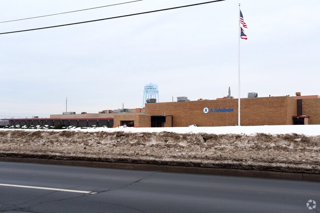
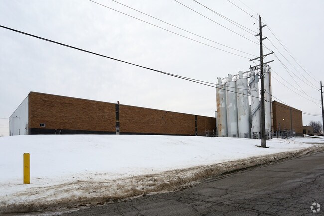
Property Record
7200 Harmon Rd, Conneaut, OH 44030

Property Detail
7200 Harmon Rd
Cleveland-Elyria, OH
15
280150000800
ASHTABULA
Industrialgeneral
Ohio
B and X Area of moderate flood hazard, usually the area between the limits of the 100-year and 500-year floods.
15
2024
34.01 AC
2024
Ashtabula County
000200
Cleveland
289,019 SF
NEARBY LISTINGS FOR SALE OR LEASE
-
-
View all Conneaut listings for sale on LoopNet.com
DEMOGRAPHICS near 7200 Harmon Rd
1 mile
3 mile
5 mile
2025 Total Population
726
4,427
9,249
2030 Population
707
4,339
9,168
Pop Growth 2025-2030
(2.62%)
(1.99%)
(0.88%)
Average Age
45
45
45
2025 Total Households
286
1,818
3,955
HH Growth 2025-2030
(2.80%)
(2.09%)
(0.81%)
Median Household Inc
$74,099
$70,411
$59,741
Avg Household Size
2.40
2.30
2.20
2025 Avg HH Vehicles
2.00
2.00
2.00
Median Home Value
$176,399
$175,233
$163,169
Median Year Built
1972
1965
1961
Nearby Places
Map Layers
Map Styles
 Street
 Aerial
Layers
 Traffic
 Biking
Places
Listings with unknown addresses are not visible on the map
- Restaurants
- Banks
- Shops
- Fitness
- Groceries
PUBLIC TRANSPORTATION
AIRPORT
Erie International/Tom Ridge Field
Drive
Walk
Distance
Erie International/Tom Ridge Field
46 min
29.5 mi
Freight Ports
Port of Toledo
Drive
Walk
Distance
Port of Toledo
214 min
180.4 mi
Nearby Properties
Address
Land Use
TOTAL SIZE
Lot Size
Zoning
Address
Land Use
TOTAL SIZE
Lot Size
Zoning
98,831 SF
13.28 AC
Address
Land Use
TOTAL SIZE
Lot Size
Zoning
23,154 SF
36.96 AC
Address
Land Use
TOTAL SIZE
Lot Size
Zoning
110,576 SF
17.91 AC
Address
Land Use
TOTAL SIZE
Lot Size
Zoning
4,576 SF
208.55 AC
Address
Land Use
TOTAL SIZE
Lot Size
Zoning
60,109 SF
10 AC
Address
Land Use
TOTAL SIZE
Lot Size
Zoning
6,136 SF
70.55 AC
Address
Land Use
TOTAL SIZE
Lot Size
Zoning
16,872 SF
45.37 AC
Address
Land Use
TOTAL SIZE
Lot Size
Zoning
1,057 SF
56.20 AC
Address
Land Use
TOTAL SIZE
Lot Size
Zoning
6,487 SF
10.40 AC
Address
Land Use
TOTAL SIZE
Lot Size
Zoning
5,736 SF
7.18 AC
Address
Land Use
TOTAL SIZE
Lot Size
Zoning
8,968 SF
6.99 AC
Address
Land Use
TOTAL SIZE
Lot Size
Zoning
3,228 SF
10.76 AC
Address
Land Use
TOTAL SIZE
Lot Size
Zoning
8,808 SF
29.75 AC
Address
Land Use
TOTAL SIZE
Lot Size
Zoning
17,150 SF
6.66 AC
Address
Land Use
TOTAL SIZE
Lot Size
Zoning
20,516 SF
2.44 AC
Address
Land Use
TOTAL SIZE
Lot Size
Zoning
6,488 SF
13.78 AC
Address
Land Use
TOTAL SIZE
Lot Size
Zoning
13,782 SF
1.21 AC
Address
Land Use
TOTAL SIZE
Lot Size
Zoning
18,372 SF
3 AC
Address
Land Use
TOTAL SIZE
Lot Size
Zoning
266.34 AC
Address
Land Use
TOTAL SIZE
Lot Size
Zoning
1.75 AC
Address
Land Use
TOTAL SIZE
Lot Size
Zoning
31,785 SF
6.53 AC
Address
Land Use
TOTAL SIZE
Lot Size
Zoning
148 AC
Address
Land Use
TOTAL SIZE
Lot Size
Zoning
Address
Land Use
TOTAL SIZE
Lot Size
Zoning
9,160 SF
4.45 AC
Address
Land Use
TOTAL SIZE
Lot Size
Zoning
2,124 SF
8.97 AC
Address
Land Use
TOTAL SIZE
Lot Size
Zoning
2,312 SF
2.49 AC
Address
Land Use
TOTAL SIZE
Lot Size
Zoning
148.29 AC
Address
Land Use
TOTAL SIZE
Lot Size
Zoning
3,240 SF
11.72 AC
Address
Land Use
TOTAL SIZE
Lot Size
Zoning
4,416 SF
10.61 AC
The World's #1 Commercial Real Estate Marketplace
Connect with us
© 2026 CoStar Group
The information above has been obtained from sources believed reliable. While we do not doubt its accuracy we have not verified it and make no guarantee, warranty or representation about it. It is your responsibility to independently confirm its accuracy and completeness. Any projections, opinions, assumptions, or estimates used are for example only and do not represent the current or future performance of the property. The value of this transaction to you depends on tax and other factors which should be evaluated by your tax, financial, and legal advisors. You and your advisors should conduct a careful, independent investigation of the property to determine to your satisfaction the suitability of the property for your needs.