Property Record
7200 Highway 329, Crestwood, KY 40014


NEARBY LISTINGS FOR SALE OR LEASE
-
-
View all Crestwood listings for sale on LoopNet.com
Property Detail
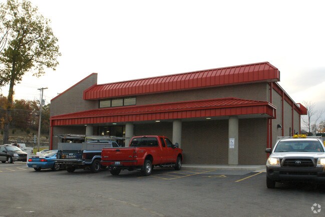
7200 Highway 329
Louisville-Jefferson County, KY-IN
Sw
23-00-00-15C&15Q
FIVE STAR & 1.806AC AT KY 329 & I71
Commercialnec
Oldham
X
Kentucky
21185C0205E
15c&15q
2025
1.81 AC
2025
Oldham County
030601
Louisville
DEMOGRAPHICS near 7200 Highway 329
1 Mile
3 Mile
5 Mile
2024 Total Population
2,596
19,003
69,033
2029 Population
2,768
19,843
70,912
Pop Growth 2024-2029
+ 6.63%
+ 4.42%
+ 2.72%
Average Age
37
39
40
2024 Total Households
904
6,598
25,071
HH Growth 2024-2029
+ 6.53%
+ 4.43%
+ 2.52%
Median Household Inc
$124,073
$104,556
$104,834
Avg Household Size
2.90
2.80
2.60
2024 Avg HH Vehicles
2.00
2.00
2.00
Median Home Value
$378,930
$332,410
$345,409
Median Year Built
2003
1992
1998
Nearby Places
Map Layers
Map Styles
 Street
 Aerial
- Restaurants
- Banks
- Shops
- Fitness
- Groceries
PUBLIC TRANSPORTATION
AIRPORT
Louisville Muhammad Ali International
DRIVE
WALK
Distance
Louisville Muhammad Ali International
35 min
23.4 mi
Freight Ports
Port of Toledo
DRIVE
WALK
Distance
Port of Toledo
332 min
288.1 mi
Nearby Properties
Address
Land Use
TOTAL SIZE
Lot Size
Zoning
Address
Land Use
TOTAL SIZE
Lot Size
Zoning
0.67 AC
Address
Land Use
TOTAL SIZE
Lot Size
Zoning
19.95 AC
Address
Land Use
TOTAL SIZE
Lot Size
Zoning
292.78 AC
Address
Land Use
TOTAL SIZE
Lot Size
Zoning
Address
Land Use
TOTAL SIZE
Lot Size
Zoning
10 AC
Address
Land Use
TOTAL SIZE
Lot Size
Zoning
Address
Land Use
TOTAL SIZE
Lot Size
Zoning
7.36 AC
Address
Land Use
TOTAL SIZE
Lot Size
Zoning
Address
Land Use
TOTAL SIZE
Lot Size
Zoning
5.25 AC
Address
Land Use
TOTAL SIZE
Lot Size
Zoning
1.41 AC
Address
Land Use
TOTAL SIZE
Lot Size
Zoning
Address
Land Use
TOTAL SIZE
Lot Size
Zoning
Address
Land Use
TOTAL SIZE
Lot Size
Zoning
3.39 AC
Address
Land Use
TOTAL SIZE
Lot Size
Zoning
Address
Land Use
TOTAL SIZE
Lot Size
Zoning
Address
Land Use
TOTAL SIZE
Lot Size
Zoning
3.45 AC
Address
Land Use
TOTAL SIZE
Lot Size
Zoning
Address
Land Use
TOTAL SIZE
Lot Size
Zoning
Address
Land Use
TOTAL SIZE
Lot Size
Zoning
2.12 AC
Address
Land Use
TOTAL SIZE
Lot Size
Zoning
Address
Land Use
TOTAL SIZE
Lot Size
Zoning
Address
Land Use
TOTAL SIZE
Lot Size
Zoning
1.46 AC
Address
Land Use
TOTAL SIZE
Lot Size
Zoning
2.63 AC
Address
Land Use
TOTAL SIZE
Lot Size
Zoning
Address
Land Use
TOTAL SIZE
Lot Size
Zoning
Address
Land Use
TOTAL SIZE
Lot Size
Zoning
56.03 AC
COM
Address
Land Use
TOTAL SIZE
Lot Size
Zoning
4.75 AC
Address
Land Use
TOTAL SIZE
Lot Size
Zoning
Address
Land Use
TOTAL SIZE
Lot Size
Zoning
The World's #1 Commercial Real Estate Marketplace
Connect with us
© 2026 CoStar Group
The information above has been obtained from sources believed reliable. While we do not doubt its accuracy we have not verified it and make no guarantee, warranty or representation about it. It is your responsibility to independently confirm its accuracy and completeness. Any projections, opinions, assumptions, or estimates used are for example only and do not represent the current or future performance of the property. The value of this transaction to you depends on tax and other factors which should be evaluated by your tax, financial, and legal advisors. You and your advisors should conduct a careful, independent investigation of the property to determine to your satisfaction the suitability of the property for your needs.