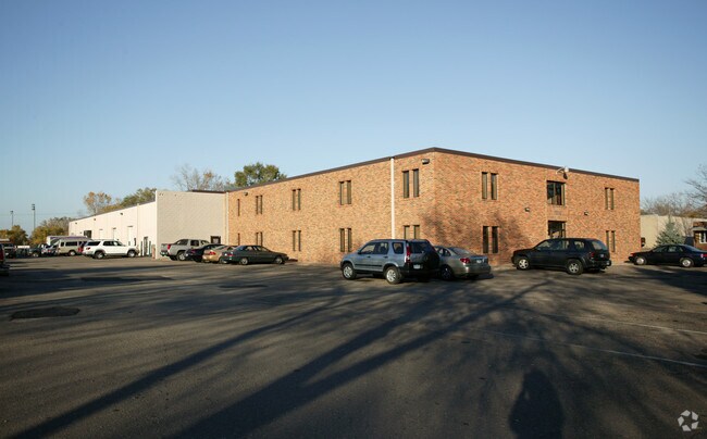
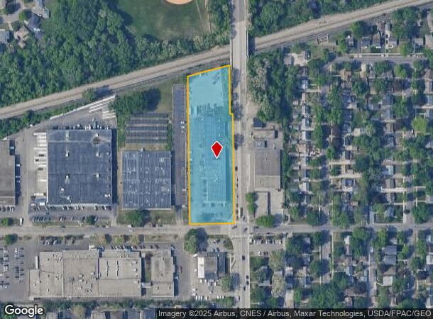
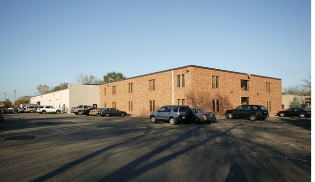
Property Record
7204 W 27Th St, Minneapolis, MN 55426

Current Lease Availabilities
NEARBY LISTINGS FOR SALE OR LEASE
Property Detail
7204 W 27Th St
Minneapolis-St. Paul-Bloomington, MN-WI
Astlefords Park
08-117-21-31-0002
LOT 001 BLOCK 001 T ASTLEFORDS PARK LOT 1 AND THAT PART OF LOT 2 LYING E OF THE W 125 FT THOF SUBJECT TO ROAD IRREGULAR
Industrialgeneral
Hennepin
X
Minnesota
27053C0353F
1
2024
2.35 AC
2024
Southwest
022400
Minneapolis/St Paul
31,800 SF
DEMOGRAPHICS near 7204 W 27Th St
1 Mile
3 Mile
5 Mile
2024 Total Population
16,789
97,720
317,056
2029 Population
16,407
96,278
312,453
Pop Growth 2024-2029
(2.28%)
(1.48%)
(1.45%)
Average Age
38
40
39
2024 Total Households
7,518
46,619
145,472
HH Growth 2024-2029
(2.43%)
(1.46%)
(1.44%)
Median Household Inc
$87,990
$89,692
$82,796
Avg Household Size
2.20
2.00
2.10
2024 Avg HH Vehicles
2.00
2.00
2.00
Median Home Value
$326,170
$376,800
$387,518
Median Year Built
1958
1970
1964
Nearby Places
Map Layers
Map Styles
 Street
 Aerial
- Restaurants
- Banks
- Shops
- Fitness
- Groceries
PUBLIC TRANSPORTATION
COMMUTER RAIL
Target Field Station (Northstar Corridor - Northstar Commuter Rail)
DRIVE
WALK
Distance
Target Field Station (Northstar Corridor - Northstar Commuter Rail)
11 min
6.5 mi
AIRPORT
Minneapolis-St Paul International/Wold-Chamberlain
DRIVE
WALK
Distance
Minneapolis-St Paul International/Wold-Chamberlain
25 min
15.8 mi
Freight Ports
Port Milwaukee
DRIVE
WALK
Distance
Port Milwaukee
384 min
345.1 mi
Nearby Properties
Address
Land Use
TOTAL SIZE
Lot Size
Zoning
Address
Land Use
TOTAL SIZE
Lot Size
Zoning
Address
Land Use
TOTAL SIZE
Lot Size
Zoning
659,076 SF
1.45 AC
C3A
Address
Land Use
TOTAL SIZE
Lot Size
Zoning
5.84 AC
Address
Land Use
TOTAL SIZE
Lot Size
Zoning
3,008,334 SF
7.72 AC
Address
Land Use
TOTAL SIZE
Lot Size
Zoning
Address
Land Use
TOTAL SIZE
Lot Size
Zoning
Address
Land Use
TOTAL SIZE
Lot Size
Zoning
Address
Land Use
TOTAL SIZE
Lot Size
Zoning
2,207,532 SF
11.15 AC
Address
Land Use
TOTAL SIZE
Lot Size
Zoning
4,497,396 SF
11.05 AC
Address
Land Use
TOTAL SIZE
Lot Size
Zoning
264,176 SF
1.61 AC
OR2
Address
Land Use
TOTAL SIZE
Lot Size
Zoning
Address
Land Use
TOTAL SIZE
Lot Size
Zoning
390,060 SF
3.11 AC
Address
Land Use
TOTAL SIZE
Lot Size
Zoning
406,842 SF
1.59 AC
Address
Land Use
TOTAL SIZE
Lot Size
Zoning
19.75 AC
Address
Land Use
TOTAL SIZE
Lot Size
Zoning
224,581 SF
13.72 AC
PUD
Address
Land Use
TOTAL SIZE
Lot Size
Zoning
398,595 SF
1.91 AC
Address
Land Use
TOTAL SIZE
Lot Size
Zoning
288,096 SF
10.19 AC
Address
Land Use
TOTAL SIZE
Lot Size
Zoning
524,556 SF
4.56 AC
Address
Land Use
TOTAL SIZE
Lot Size
Zoning
Address
Land Use
TOTAL SIZE
Lot Size
Zoning
Address
Land Use
TOTAL SIZE
Lot Size
Zoning
280,748 SF
1.60 AC
Address
Land Use
TOTAL SIZE
Lot Size
Zoning
2.58 AC
Address
Land Use
TOTAL SIZE
Lot Size
Zoning
379,488 SF
2.68 AC
Address
Land Use
TOTAL SIZE
Lot Size
Zoning
340,330 SF
2.22 AC
Address
Land Use
TOTAL SIZE
Lot Size
Zoning
576,900 SF
25.79 AC
OR2
Address
Land Use
TOTAL SIZE
Lot Size
Zoning
Address
Land Use
TOTAL SIZE
Lot Size
Zoning
Address
Land Use
TOTAL SIZE
Lot Size
Zoning
127,084 SF
17.21 AC
Address
Land Use
TOTAL SIZE
Lot Size
Zoning
244,941 SF
5.24 AC
Address
Land Use
TOTAL SIZE
Lot Size
Zoning
239,539 SF
1.29 AC
OR2
The World's #1 Commercial Real Estate Marketplace
Connect with us
© 2026 CoStar Group
The information above has been obtained from sources believed reliable. While we do not doubt its accuracy we have not verified it and make no guarantee, warranty or representation about it. It is your responsibility to independently confirm its accuracy and completeness. Any projections, opinions, assumptions, or estimates used are for example only and do not represent the current or future performance of the property. The value of this transaction to you depends on tax and other factors which should be evaluated by your tax, financial, and legal advisors. You and your advisors should conduct a careful, independent investigation of the property to determine to your satisfaction the suitability of the property for your needs.