Property Record
7205 Aurora Rd, Aurora, OH 44202
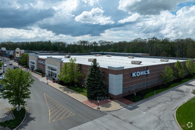

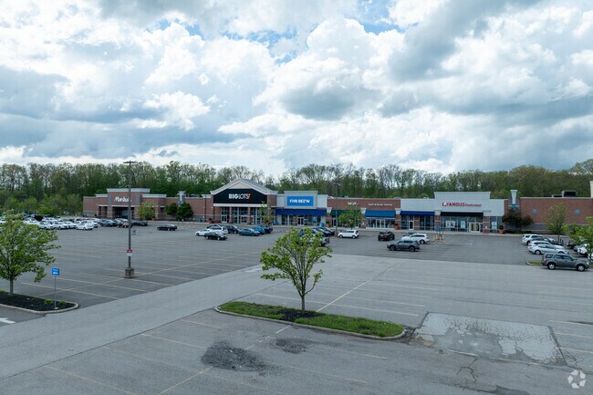
Property Detail
7205 Aurora Rd
02-421197
S/L 8D REMAINDER OF S/L 8 RESUB
Communitycenter
GEAUGA
CR
Ohio
B and X Area of moderate flood hazard, usually the area between the limits of the 100-year and 500-year floods.
43.36 AC
2025
Geauga County
2025
Cleveland
311800
Cleveland-Elyria, OH
116,598 SF
NEARBY LISTINGS FOR SALE OR LEASE
-
-
View all Aurora listings for lease on LoopNet.com
DEMOGRAPHICS near 7205 Aurora Rd
1 mile
3 mile
5 mile
2025 Total Population
3,349
32,614
74,612
2030 Population
3,301
32,571
74,518
Pop Growth 2025-2030
(1.43%)
(0.13%)
(0.13%)
Average Age
42
42
43
2025 Total Households
1,263
12,385
28,484
HH Growth 2025-2030
(1.58%)
(0.14%)
(0.11%)
Median Household Inc
$93,723
$118,873
$116,166
Avg Household Size
2.50
2.60
2.50
2025 Avg HH Vehicles
2.00
2.00
2.00
Median Home Value
$278,279
$397,710
$369,997
Median Year Built
1989
1992
1986
Nearby Places
Map Layers
Map Styles
 Street
 Aerial
Transit
 Traffic
 Biking
Places
Listings with unknown addresses are not visible on the map
- Restaurants
- Banks
- Shops
- Fitness
- Groceries
PUBLIC TRANSPORTATION
AIRPORT
Cleveland-Hopkins International
Drive
Walk
Distance
Cleveland-Hopkins International
47 min
28.7 mi
Akron-Canton Regional
Drive
Walk
Distance
Akron-Canton Regional
61 min
38.6 mi
SALE & LEASE HISTORY
LISTING DATE
SALE/LEASE

Sep 25, 2016
For Lease
Nov 25, 2025
For Lease
May 10, 2018
For Lease
Mar 07, 2017
For Lease
Jul 19, 2017
For Lease
Jul 05, 2017
For Lease
Jan 24, 2024
For Lease
Feb 21, 2017
For Lease
Apr 16, 2021
For Lease
Apr 06, 2017
For Lease
Nearby Properties
Address
Land Use
TOTAL SIZE
Lot Size
Zoning
Address
Land Use
TOTAL SIZE
Lot Size
Zoning
246,138 SF
67.82 AC
R-1-C
Address
Land Use
TOTAL SIZE
Lot Size
Zoning
96,632 SF
13.87 AC
R-3
Address
Land Use
TOTAL SIZE
Lot Size
Zoning
29,560 SF
4.46 AC
R-3
Address
Land Use
TOTAL SIZE
Lot Size
Zoning
342,068 SF
29.02 AC
Address
Land Use
TOTAL SIZE
Lot Size
Zoning
151,032 SF
40.13 AC
Address
Land Use
TOTAL SIZE
Lot Size
Zoning
177,246 SF
40.56 AC
R5A
Address
Land Use
TOTAL SIZE
Lot Size
Zoning
90,287 SF
66.28 AC
G-2
Address
Land Use
TOTAL SIZE
Lot Size
Zoning
153,194 SF
11.31 AC
Address
Land Use
TOTAL SIZE
Lot Size
Zoning
116,597 SF
11.36 AC
CR
Address
Land Use
TOTAL SIZE
Lot Size
Zoning
62,067 SF
30.96 AC
Address
Land Use
TOTAL SIZE
Lot Size
Zoning
239,248 SF
22.62 AC
Address
Land Use
TOTAL SIZE
Lot Size
Zoning
61,222 SF
19.01 AC
Address
Land Use
TOTAL SIZE
Lot Size
Zoning
194,480 SF
17.77 AC
CR
Address
Land Use
TOTAL SIZE
Lot Size
Zoning
15,841 SF
360.14 AC
G-2
Address
Land Use
TOTAL SIZE
Lot Size
Zoning
106,440 SF
14.25 AC
CR
Address
Land Use
TOTAL SIZE
Lot Size
Zoning
59,115 SF
3.12 AC
Address
Land Use
TOTAL SIZE
Lot Size
Zoning
30,880 SF
10.29 AC
Address
Land Use
TOTAL SIZE
Lot Size
Zoning
57,730 SF
1.97 AC
R-3-B
Address
Land Use
TOTAL SIZE
Lot Size
Zoning
127,518 SF
13.10 AC
CR
Address
Land Use
TOTAL SIZE
Lot Size
Zoning
24.54 AC
Address
Land Use
TOTAL SIZE
Lot Size
Zoning
25,288 SF
28.71 AC
CR
Address
Land Use
TOTAL SIZE
Lot Size
Zoning
20,554 SF
86.64 AC
Address
Land Use
TOTAL SIZE
Lot Size
Zoning
81,146 SF
5.35 AC
Address
Land Use
TOTAL SIZE
Lot Size
Zoning
37,373 SF
7.84 AC
Address
Land Use
TOTAL SIZE
Lot Size
Zoning
86,970 SF
8.33 AC
CR
Address
Land Use
TOTAL SIZE
Lot Size
Zoning
86,493 SF
10.27 AC
Address
Land Use
TOTAL SIZE
Lot Size
Zoning
61,674 SF
4.20 AC
Address
Land Use
TOTAL SIZE
Lot Size
Zoning
30,862 SF
13.40 AC
Address
Land Use
TOTAL SIZE
Lot Size
Zoning
50,024 SF
3.70 AC
The World's #1 Commercial Real Estate Marketplace
Connect with us
© 2026 CoStar Group
The information above has been obtained from sources believed reliable. While we do not doubt its accuracy we have not verified it and make no guarantee, warranty or representation about it. It is your responsibility to independently confirm its accuracy and completeness. Any projections, opinions, assumptions, or estimates used are for example only and do not represent the current or future performance of the property. The value of this transaction to you depends on tax and other factors which should be evaluated by your tax, financial, and legal advisors. You and your advisors should conduct a careful, independent investigation of the property to determine to your satisfaction the suitability of the property for your needs.