Property Record
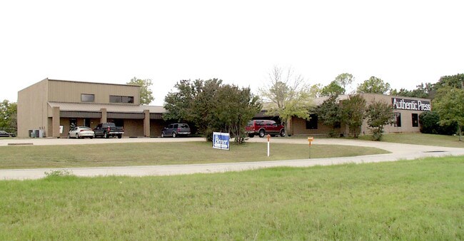
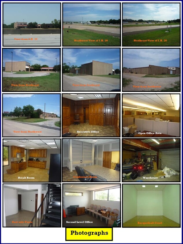
7208 E Interstate 20, Kennedale, TX 76060


Property Detail
7208 E Interstate 20
Dallas-Fort Worth-Arlington, TX
A & A ADDITION BLOCK 2 LOT 1R
42452366
TARRANT
Commercialnec
Texas
B and X Area of moderate flood hazard, usually the area between the limits of the 100-year and 500-year floods.
1r
2025
1.59 AC
2025
Arlington/Mansfield
111411
Dallas/Ft Worth
28,870 SF
NEARBY LISTINGS FOR SALE OR LEASE
DEMOGRAPHICS near 7208 E Interstate 20
1 mile
3 mile
5 mile
2025 Total Population
10,478
75,456
199,901
2030 Population
10,991
79,392
210,349
Pop Growth 2025-2030
+ 4.90%
+ 5.22%
+ 5.23%
Average Age
39
39
38
2025 Total Households
4,146
26,958
68,152
HH Growth 2025-2030
+ 5.09%
+ 5.33%
+ 5.33%
Median Household Inc
$70,815
$77,470
$71,611
Avg Household Size
2.50
2.80
2.80
2025 Avg HH Vehicles
2.00
2.00
2.00
Median Home Value
$353,864
$299,220
$290,996
Median Year Built
1987
1985
1982
Nearby Places
Map Layers
Map Styles
 Street
 Aerial
Transit
 Traffic
 Biking
Places
Listings with unknown addresses are not visible on the map
- Restaurants
- Banks
- Shops
- Fitness
- Groceries
PUBLIC TRANSPORTATION
COMMUTER RAIL
Drive
Walk
Distance
15 min
9.8 mi
Drive
Walk
Distance
15 min
9.9 mi
AIRPORT
Dallas-Fort Worth International
Drive
Walk
Distance
Dallas-Fort Worth International
38 min
27.5 mi
Dallas Love Field
Drive
Walk
Distance
Dallas Love Field
47 min
36.5 mi
Nearby Properties
Address
Land Use
TOTAL SIZE
Lot Size
Zoning
Address
Land Use
TOTAL SIZE
Lot Size
Zoning
569,312 SF
71.52 AC
Address
Land Use
TOTAL SIZE
Lot Size
Zoning
256,088 SF
10.27 AC
Address
Land Use
TOTAL SIZE
Lot Size
Zoning
605,489 SF
35.12 AC
Address
Land Use
TOTAL SIZE
Lot Size
Zoning
214,444 SF
17.45 AC
Address
Land Use
TOTAL SIZE
Lot Size
Zoning
167,643 SF
8.99 AC
Address
Land Use
TOTAL SIZE
Lot Size
Zoning
186,894 SF
10.85 AC
Address
Land Use
TOTAL SIZE
Lot Size
Zoning
169,347 SF
13.92 AC
Address
Land Use
TOTAL SIZE
Lot Size
Zoning
222,500 SF
13.86 AC
Address
Land Use
TOTAL SIZE
Lot Size
Zoning
169,837 SF
9.44 AC
Address
Land Use
TOTAL SIZE
Lot Size
Zoning
180,556 SF
11.78 AC
Address
Land Use
TOTAL SIZE
Lot Size
Zoning
147,822 SF
9.45 AC
Address
Land Use
TOTAL SIZE
Lot Size
Zoning
193,290 SF
10.56 AC
Address
Land Use
TOTAL SIZE
Lot Size
Zoning
239,360 SF
17.55 AC
Address
Land Use
TOTAL SIZE
Lot Size
Zoning
159,030 SF
10.32 AC
Address
Land Use
TOTAL SIZE
Lot Size
Zoning
238,119 SF
7.52 AC
Address
Land Use
TOTAL SIZE
Lot Size
Zoning
142,110 SF
7.40 AC
Address
Land Use
TOTAL SIZE
Lot Size
Zoning
119,741 SF
45 AC
Address
Land Use
TOTAL SIZE
Lot Size
Zoning
171,684 SF
8.12 AC
Address
Land Use
TOTAL SIZE
Lot Size
Zoning
4,886 SF
45.16 AC
Address
Land Use
TOTAL SIZE
Lot Size
Zoning
255,568 SF
14.79 AC
Address
Land Use
TOTAL SIZE
Lot Size
Zoning
2,058 SF
37.92 AC
Address
Land Use
TOTAL SIZE
Lot Size
Zoning
246,423 SF
18.84 AC
Address
Land Use
TOTAL SIZE
Lot Size
Zoning
86,013 SF
3.89 AC
Address
Land Use
TOTAL SIZE
Lot Size
Zoning
189,323 SF
44.29 AC
Address
Land Use
TOTAL SIZE
Lot Size
Zoning
238,977 SF
58.29 AC
Address
Land Use
TOTAL SIZE
Lot Size
Zoning
259,627 SF
18.87 AC
Address
Land Use
TOTAL SIZE
Lot Size
Zoning
101,030 SF
10.11 AC
Address
Land Use
TOTAL SIZE
Lot Size
Zoning
262,200 SF
18.66 AC
Address
Land Use
TOTAL SIZE
Lot Size
Zoning
64,903 SF
2.64 AC
Address
Land Use
TOTAL SIZE
Lot Size
Zoning
277,005 SF
53.52 AC
The World's #1 Commercial Real Estate Marketplace
Connect with us
© 2026 CoStar Group
The information above has been obtained from sources believed reliable. While we do not doubt its accuracy we have not verified it and make no guarantee, warranty or representation about it. It is your responsibility to independently confirm its accuracy and completeness. Any projections, opinions, assumptions, or estimates used are for example only and do not represent the current or future performance of the property. The value of this transaction to you depends on tax and other factors which should be evaluated by your tax, financial, and legal advisors. You and your advisors should conduct a careful, independent investigation of the property to determine to your satisfaction the suitability of the property for your needs.