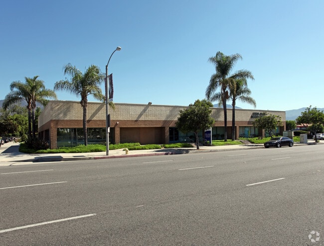
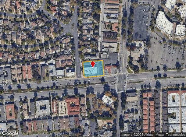
Property Record
721 W Huntington Dr, Arcadia, CA 91007
NEARBY LISTINGS FOR SALE OR LEASE
Property Detail
721 W Huntington Dr
Los Angeles-Long Beach-Glendale, CA
949
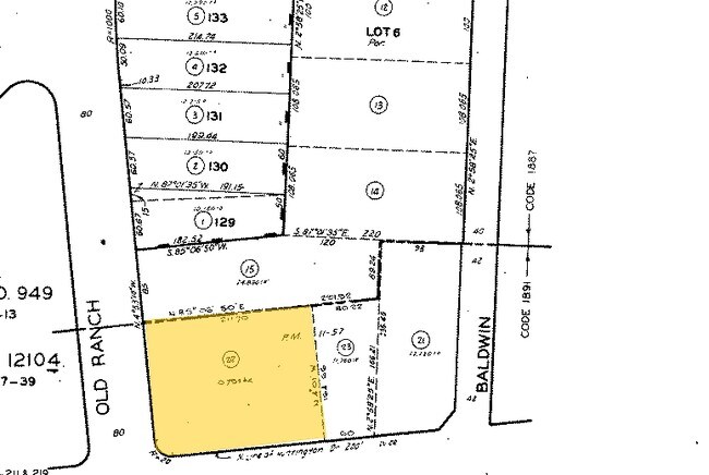
5777-028-022
TRACT NO 949 LOT COM S ON E LINE OF OLD RANCH RD 85 FT FROM SW COR OF LOT 129 TR NO 12104 TH N 85 0650 E 211.7 FT TH S 4 01 E TO N LINE OF HUNTINGTON DR TH W THEREON AND N ON SD RD TO BEG PART OF LOT 6
Officebuilding
Los Angeles
X
California
06037C1400F
129
2024
0.79 AC
2025
Western SGV
430701
Los Angeles
9,583 SF
DEMOGRAPHICS near 721 W Huntington Dr
1 Mile
3 Mile
5 Mile
2024 Total Population
24,530
177,575
443,730
2029 Population
23,929
172,083
429,346
Pop Growth 2024-2029
(2.45%)
(3.09%)
(3.24%)
Average Age
42
43
42
2024 Total Households
8,747
62,077
152,739
HH Growth 2024-2029
(2.68%)
(3.33%)
(3.43%)
Median Household Inc
$84,814
$99,865
$87,615
Avg Household Size
2.70
2.80
2.80
2024 Avg HH Vehicles
2.00
2.00
2.00
Median Home Value
$988,849
$993,836
$883,983
Median Year Built
1967
1958
1959
Nearby Places
Map Layers
Map Styles
 Street
 Aerial
- Restaurants
- Banks
- Shops
- Fitness
- Groceries
PUBLIC TRANSPORTATION
COMMUTER RAIL
El Monte (San Bernardino Line - Southern California Regional Rail Authority (Metrolink))
DRIVE
WALK
Distance
El Monte (San Bernardino Line - Southern California Regional Rail Authority (Metrolink))
12 min
5.5 mi
Baldwin Park (San Bernardino Line - Southern California Regional Rail Authority (Metrolink))
DRIVE
WALK
Distance
Baldwin Park (San Bernardino Line - Southern California Regional Rail Authority (Metrolink))
19 min
9.6 mi
AIRPORT
Bob Hope
DRIVE
WALK
Distance
Bob Hope
32 min
23.1 mi
Long Beach (Daugherty Field)
DRIVE
WALK
Distance
Long Beach (Daugherty Field)
44 min
29.8 mi
Los Angeles International
DRIVE
WALK
Distance
Los Angeles International
48 min
32.3 mi
Freight Ports
Port of Long Beach
DRIVE
WALK
Distance
Port of Long Beach
47 min
31.7 mi
Nearby Properties
Address
Land Use
TOTAL SIZE
Lot Size
Zoning
Address
Land Use
TOTAL SIZE
Lot Size
Zoning
945,101 SF
38.07 AC
ARC2DH-S1-
Address
Land Use
TOTAL SIZE
Lot Size
Zoning
230,045 SF
3.20 AC
PSC*
Address
Land Use
TOTAL SIZE
Lot Size
Zoning
165,341 SF
2.70 AC
ARC2YY
Address
Land Use
TOTAL SIZE
Lot Size
Zoning
531,606 SF
8.20 AC
PSC*
Address
Land Use
TOTAL SIZE
Lot Size
Zoning
299,385 SF
4.37 AC
PSC*
Address
Land Use
TOTAL SIZE
Lot Size
Zoning
237,930 SF
2.98 AC
PSC*
Address
Land Use
TOTAL SIZE
Lot Size
Zoning
210,083 SF
9.61 AC
PSMG
Address
Land Use
TOTAL SIZE
Lot Size
Zoning
294,320 SF
8.30 AC
PSC*
Address
Land Use
TOTAL SIZE
Lot Size
Zoning
144,947 SF
19.93 AC
PSC*
Address
Land Use
TOTAL SIZE
Lot Size
Zoning
127,085 SF
1.97 AC
MOCG-P/QP*
Address
Land Use
TOTAL SIZE
Lot Size
Zoning
324,257 SF
7.97 AC
PSC*
Address
Land Use
TOTAL SIZE
Lot Size
Zoning
266,084 SF
3.71 AC
PSC*
Address
Land Use
TOTAL SIZE
Lot Size
Zoning
433,378 SF
8.27 AC
PSC*
Address
Land Use
TOTAL SIZE
Lot Size
Zoning
68,417 SF
0.78 AC
ARC2H*
Address
Land Use
TOTAL SIZE
Lot Size
Zoning
358,500 SF
5.11 AC
ARC2DH-S1-
Address
Land Use
TOTAL SIZE
Lot Size
Zoning
61,020 SF
2.65 AC
PSC-
Address
Land Use
TOTAL SIZE
Lot Size
Zoning
255,384 SF
6.74 AC
ARC2*
Address
Land Use
TOTAL SIZE
Lot Size
Zoning
635,556 SF
11.05 AC
ARC2
Address
Land Use
TOTAL SIZE
Lot Size
Zoning
756,195 SF
15.48 AC
ARC2DH-S1-
Address
Land Use
TOTAL SIZE
Lot Size
Zoning
241,189 SF
0.90 AC
ARC2*
Address
Land Use
TOTAL SIZE
Lot Size
Zoning
24,015 SF
3.23 AC
ARCPD1*
Address
Land Use
TOTAL SIZE
Lot Size
Zoning
325,776 SF
8.33 AC
PSM*
Address
Land Use
TOTAL SIZE
Lot Size
Zoning
53,306 SF
0.90 AC
ARC2
Address
Land Use
TOTAL SIZE
Lot Size
Zoning
69,352 SF
4.78 AC
ARC2
Address
Land Use
TOTAL SIZE
Lot Size
Zoning
220,753 SF
3.75 AC
ARCPD1*
Address
Land Use
TOTAL SIZE
Lot Size
Zoning
131,527 SF
3.75 AC
ARCPD1&H*
Address
Land Use
TOTAL SIZE
Lot Size
Zoning
144,228 SF
2.05 AC
LCC4
Address
Land Use
TOTAL SIZE
Lot Size
Zoning
216,961 SF
1.75 AC
ARC2YY
Address
Land Use
TOTAL SIZE
Lot Size
Zoning
87,163 SF
2.99 AC
ARCO&H*
Address
Land Use
TOTAL SIZE
Lot Size
Zoning
54,465 SF
0.79 AC
MORPD*
The World's #1 Commercial Real Estate Marketplace
Connect with us
© 2025 CoStar Group
The information above has been obtained from sources believed reliable. While we do not doubt its accuracy we have not verified it and make no guarantee, warranty or representation about it. It is your responsibility to independently confirm its accuracy and completeness. Any projections, opinions, assumptions, or estimates used are for example only and do not represent the current or future performance of the property. The value of this transaction to you depends on tax and other factors which should be evaluated by your tax, financial, and legal advisors. You and your advisors should conduct a careful, independent investigation of the property to determine to your satisfaction the suitability of the property for your needs.