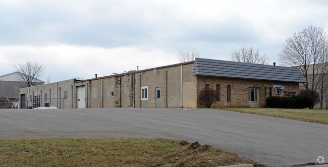
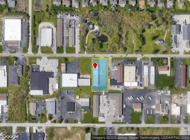
Property Record
721 Mcclurg Rd, Youngstown, OH 44512
Current Lease Availabilities
NEARBY LISTINGS FOR SALE OR LEASE
Property Detail
721 Mcclurg Rd
Youngstown/Warren/Boardman
Turnpike Indus Pk Pl 4
Youngstown-Warren, OH
LOT 13 150 X 300 TURNPIKE INDUS PK PL 4
29-047-0-007.00-0
Mahoning
Storebuilding
Ohio
2024
13
2024
1.03 AC
811902
Mahoning County
1,000 SF
DEMOGRAPHICS near 721 Mcclurg Rd
1 Mile
3 Mile
5 Mile
2024 Total Population
1,848
26,706
79,644
2029 Population
1,805
26,020
77,884
Pop Growth 2024-2029
(2.33%)
(2.57%)
(2.21%)
Average Age
49
46
44
2024 Total Households
875
11,751
34,830
HH Growth 2024-2029
(2.40%)
(2.61%)
(2.28%)
Median Household Inc
$55,306
$70,951
$59,284
Avg Household Size
2.10
2.20
2.20
2024 Avg HH Vehicles
2.00
2.00
2.00
Median Home Value
$181,692
$185,210
$156,252
Median Year Built
1986
1973
1964
Nearby Places
Map Layers
Map Styles
 Street
 Aerial
- Restaurants
- Banks
- Shops
- Fitness
- Groceries
Nearby Properties
Address
Land Use
TOTAL SIZE
Lot Size
Zoning
Address
Land Use
TOTAL SIZE
Lot Size
Zoning
471,532 SF
22.26 AC
C
Address
Land Use
TOTAL SIZE
Lot Size
Zoning
252,909 SF
22.37 AC
C
Address
Land Use
TOTAL SIZE
Lot Size
Zoning
436,605 SF
64.24 AC
C
Address
Land Use
TOTAL SIZE
Lot Size
Zoning
318,339 SF
14.66 AC
R1
Address
Land Use
TOTAL SIZE
Lot Size
Zoning
22.26 AC
Address
Land Use
TOTAL SIZE
Lot Size
Zoning
88,996 SF
10.94 AC
C
Address
Land Use
TOTAL SIZE
Lot Size
Zoning
114,056 SF
60.31 AC
GC
Address
Land Use
TOTAL SIZE
Lot Size
Zoning
71,619 SF
12.76 AC
C
Address
Land Use
TOTAL SIZE
Lot Size
Zoning
140,889 SF
14.71 AC
C
Address
Land Use
TOTAL SIZE
Lot Size
Zoning
105,326 SF
6.75 AC
Address
Land Use
TOTAL SIZE
Lot Size
Zoning
41,443 SF
0.93 AC
C
Address
Land Use
TOTAL SIZE
Lot Size
Zoning
134,650 SF
16.10 AC
C
Address
Land Use
TOTAL SIZE
Lot Size
Zoning
57,178 SF
20.42 AC
R2
Address
Land Use
TOTAL SIZE
Lot Size
Zoning
123,712 SF
16.55 AC
MFR
Address
Land Use
TOTAL SIZE
Lot Size
Zoning
49,014 SF
8.63 AC
C
Address
Land Use
TOTAL SIZE
Lot Size
Zoning
83,357 SF
6.96 AC
MFR
Address
Land Use
TOTAL SIZE
Lot Size
Zoning
61,141 SF
1.01 AC
C
Address
Land Use
TOTAL SIZE
Lot Size
Zoning
96,005 SF
3.89 AC
C
Address
Land Use
TOTAL SIZE
Lot Size
Zoning
108,150 SF
6.06 AC
C
Address
Land Use
TOTAL SIZE
Lot Size
Zoning
41,835 SF
7.46 AC
I
Address
Land Use
TOTAL SIZE
Lot Size
Zoning
Address
Land Use
TOTAL SIZE
Lot Size
Zoning
39,370 SF
10.58 AC
C
Address
Land Use
TOTAL SIZE
Lot Size
Zoning
139,722 SF
19.72 AC
R1
Address
Land Use
TOTAL SIZE
Lot Size
Zoning
92,063 SF
13.03 AC
GC
Address
Land Use
TOTAL SIZE
Lot Size
Zoning
141,528 SF
16.11 AC
C
Address
Land Use
TOTAL SIZE
Lot Size
Zoning
23,583 SF
9.76 AC
C
Address
Land Use
TOTAL SIZE
Lot Size
Zoning
140,132 SF
8.91 AC
C
Address
Land Use
TOTAL SIZE
Lot Size
Zoning
123,138 SF
8.16 AC
C
Address
Land Use
TOTAL SIZE
Lot Size
Zoning
68,415 SF
11.60 AC
R1
Address
Land Use
TOTAL SIZE
Lot Size
Zoning
29,735 SF
8.65 AC
C
The World's #1 Commercial Real Estate Marketplace
Connect with us
© 2026 CoStar Group
The information above has been obtained from sources believed reliable. While we do not doubt its accuracy we have not verified it and make no guarantee, warranty or representation about it. It is your responsibility to independently confirm its accuracy and completeness. Any projections, opinions, assumptions, or estimates used are for example only and do not represent the current or future performance of the property. The value of this transaction to you depends on tax and other factors which should be evaluated by your tax, financial, and legal advisors. You and your advisors should conduct a careful, independent investigation of the property to determine to your satisfaction the suitability of the property for your needs.