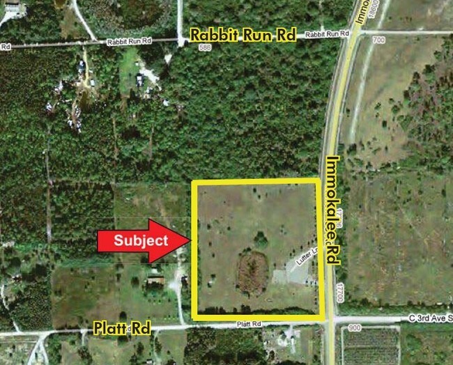
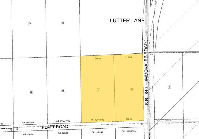
Property Record
721 Platt Rd, Naples, FL 34120
Save to a Folder
{{folder.Name}}
{{folder.ListingIds.length}} Properties
{{folder.ListingIds.length}} Property
Create a New Folder
Property Detail
721 Platt Rd
00111240005
27 47 27 NE1/4 OF NE1/4 OF SE1/4, LESS 4.24 AC DESC IN OR 1387 PG 1767 & RW
Commercialacreage
COLLIER
MH
Florida
AH Areas with a 1% annual chance of shallow flooding, usually in the form of a pond, withan average depth ranging from 1 to 3 feet. These areas have a 26% chance of flooding over the life of a 30-year mortgage.
4.34 AC
2024
Outlying Collier County
2025
Southwest Florida
011212
Naples-Marco Island, FL
NEARBY LISTINGS FOR SALE OR LEASE
-
-
View all Naples listings for sale on LoopNet.com
DEMOGRAPHICS near 721 Platt Rd
1 mile
3 mile
5 mile
2025 Total Population
196
1,491
13,584
2030 Population
206
1,575
14,851
Pop Growth 2025-2030
+ 5.10%
+ 5.63%
+ 9.33%
Average Age
37
37
43
2025 Total Households
57
436
4,718
HH Growth 2025-2030
+ 5.26%
+ 4.59%
+ 9.45%
Median Household Inc
$85,416
$90,833
$118,020
Avg Household Size
3.20
3.10
2.70
2025 Avg HH Vehicles
3.00
3.00
2.00
Median Home Value
$461,904
$463,244
$496,865
Median Year Built
2000
2002
2009
Nearby Places
Map Layers
Map Styles
 Street
 Aerial
Layers
 Traffic
 Biking
Places
Listings with unknown addresses are not visible on the map
- Restaurants
- Banks
- Shops
- Fitness
- Groceries
PUBLIC TRANSPORTATION
AIRPORT
Southwest Florida International
Drive
Walk
Distance
Southwest Florida International
51 min
37.2 mi
Freight Ports
Port Everglades
Drive
Walk
Distance
Port Everglades
129 min
109.0 mi
Nearby Properties
Address
Land Use
TOTAL SIZE
Lot Size
Zoning
Address
Land Use
TOTAL SIZE
Lot Size
Zoning
23,765 SF
320 AC
CON
Address
Land Use
TOTAL SIZE
Lot Size
Zoning
672 SF
633.94 AC
A-MHO
Address
Land Use
TOTAL SIZE
Lot Size
Zoning
313.94 AC
A-MHO
Address
Land Use
TOTAL SIZE
Lot Size
Zoning
27,100 SF
4.39 AC
A-MHO
Address
Land Use
TOTAL SIZE
Lot Size
Zoning
3,835 SF
5 AC
A-MHO
Address
Land Use
TOTAL SIZE
Lot Size
Zoning
16,500 SF
4.34 AC
A-MHO
Address
Land Use
TOTAL SIZE
Lot Size
Zoning
3,600 SF
14.63 AC
A
Address
Land Use
TOTAL SIZE
Lot Size
Zoning
2,257 SF
7.05 AC
A
Address
Land Use
TOTAL SIZE
Lot Size
Zoning
1,356 SF
40 AC
A
Address
Land Use
TOTAL SIZE
Lot Size
Zoning
600 SF
83.48 AC
A-MHO
Address
Land Use
TOTAL SIZE
Lot Size
Zoning
1,788 SF
5 AC
A
Address
Land Use
TOTAL SIZE
Lot Size
Zoning
4,146 SF
9.54 AC
A-MHO
Address
Land Use
TOTAL SIZE
Lot Size
Zoning
7,148 SF
46.56 AC
A-MHO
Address
Land Use
TOTAL SIZE
Lot Size
Zoning
4,976 SF
8.79 AC
A-MHO
Address
Land Use
TOTAL SIZE
Lot Size
Zoning
3,234 SF
9.11 AC
A-MHO
Address
Land Use
TOTAL SIZE
Lot Size
Zoning
1,798 SF
19.29 AC
E
Address
Land Use
TOTAL SIZE
Lot Size
Zoning
2,952 SF
4.77 AC
A
Address
Land Use
TOTAL SIZE
Lot Size
Zoning
4,004 SF
3.99 AC
A-MHO
Address
Land Use
TOTAL SIZE
Lot Size
Zoning
100 AC
A-MHO
Address
Land Use
TOTAL SIZE
Lot Size
Zoning
1,262 SF
4.75 AC
A
Address
Land Use
TOTAL SIZE
Lot Size
Zoning
4.24 AC
C-2
Address
Land Use
TOTAL SIZE
Lot Size
Zoning
2,692 SF
5 AC
A-MHO
Address
Land Use
TOTAL SIZE
Lot Size
Zoning
3,228 SF
4.34 AC
A-MHO
Address
Land Use
TOTAL SIZE
Lot Size
Zoning
2,048 SF
5.46 AC
E
Address
Land Use
TOTAL SIZE
Lot Size
Zoning
2,422 SF
3.86 AC
A-MHO
Address
Land Use
TOTAL SIZE
Lot Size
Zoning
4,072 SF
7.50 AC
A-MHO
The World's #1 Commercial Real Estate Marketplace
Connect with us
© 2026 CoStar Group
The information above has been obtained from sources believed reliable. While we do not doubt its accuracy we have not verified it and make no guarantee, warranty or representation about it. It is your responsibility to independently confirm its accuracy and completeness. Any projections, opinions, assumptions, or estimates used are for example only and do not represent the current or future performance of the property. The value of this transaction to you depends on tax and other factors which should be evaluated by your tax, financial, and legal advisors. You and your advisors should conduct a careful, independent investigation of the property to determine to your satisfaction the suitability of the property for your needs.