Property Record
721 Sw 19Th Ave, Ocala, FL 34471

NEARBY LISTINGS FOR SALE OR LEASE
-
-
View all Ocala listings for sale on LoopNet.com
Property Detail
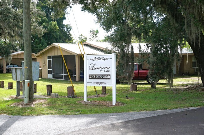
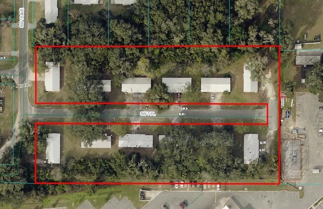
721 Sw 19Th Ave
22739-001-00
I & P Apartments
Apartment
SEC 13 TWP 15 RGE 21 S 1/4 OF SE 1/4 OF SE 1/4 EXC E 666.83 FT & EXC RD ROW & EXC N 50 FT OF S 190 FT OF S 1/2 OF SE 1/4 OF SE 1/4 LESS E 666.83 & LESS W 30 FT THAT PORTION OF W 1/2 OF ABROGATED SW 17TH AVE (PLATTED 25TH ST) PER RES 2000-109 DESC AS
X
Marion
12083C0517E
Florida
2024
3.89 AC
2024
Southeast Ocala
001700
Ocala
17,416 SF
Ocala, FL
DEMOGRAPHICS near 721 Sw 19Th Ave
1 Mile
3 Mile
5 Mile
2024 Total Population
6,886
39,985
90,141
2029 Population
7,814
44,998
100,596
Pop Growth 2024-2029
+ 13.48%
+ 12.54%
+ 11.60%
Average Age
37
40
41
2024 Total Households
2,861
15,871
36,967
HH Growth 2024-2029
+ 13.46%
+ 12.78%
+ 11.66%
Median Household Inc
$28,029
$44,434
$52,892
Avg Household Size
2.30
2.30
2.30
2024 Avg HH Vehicles
1.00
1.00
2.00
Median Home Value
$78,168
$190,473
$200,678
Median Year Built
1980
1980
1984
Nearby Places
Map Layers
Map Styles
 Street
 Aerial
- Restaurants
- Banks
- Shops
- Fitness
- Groceries
SALE & LEASE HISTORY
LISTING DATE
SALE/LEASE

Jul 24, 2024
For Sale
Nearby Properties
Address
Land Use
TOTAL SIZE
Lot Size
Zoning
Address
Land Use
TOTAL SIZE
Lot Size
Zoning
207,950 SF
14.08 AC
INST
Address
Land Use
TOTAL SIZE
Lot Size
Zoning
2,015,469 SF
169.30 AC
M1
Address
Land Use
TOTAL SIZE
Lot Size
Zoning
704,765 SF
71.04 AC
GU
Address
Land Use
TOTAL SIZE
Lot Size
Zoning
326,425 SF
11.66 AC
INST
Address
Land Use
TOTAL SIZE
Lot Size
Zoning
493,261 SF
126.01 AC
R3
Address
Land Use
TOTAL SIZE
Lot Size
Zoning
446,764 SF
138.06 AC
GU
Address
Land Use
TOTAL SIZE
Lot Size
Zoning
189,286 SF
35.42 AC
PD08
Address
Land Use
TOTAL SIZE
Lot Size
Zoning
164,363 SF
16.51 AC
R3
Address
Land Use
TOTAL SIZE
Lot Size
Zoning
195,992 SF
5.72 AC
FBC
Address
Land Use
TOTAL SIZE
Lot Size
Zoning
422,264 SF
40.87 AC
SC
Address
Land Use
TOTAL SIZE
Lot Size
Zoning
154,870 SF
23.50 AC
PD
Address
Land Use
TOTAL SIZE
Lot Size
Zoning
178,015 SF
18.28 AC
PD07
Address
Land Use
TOTAL SIZE
Lot Size
Zoning
441,040 SF
150.01 AC
M1
Address
Land Use
TOTAL SIZE
Lot Size
Zoning
458,983 SF
35.14 AC
M1
Address
Land Use
TOTAL SIZE
Lot Size
Zoning
154,675 SF
23.62 AC
PD09
Address
Land Use
TOTAL SIZE
Lot Size
Zoning
111,644 SF
19 AC
PD09
Address
Land Use
TOTAL SIZE
Lot Size
Zoning
222,210 SF
22.14 AC
SC
Address
Land Use
TOTAL SIZE
Lot Size
Zoning
110,226 SF
19.56 AC
PD09
Address
Land Use
TOTAL SIZE
Lot Size
Zoning
421,243 SF
51.48 AC
M2
Address
Land Use
TOTAL SIZE
Lot Size
Zoning
92,049 SF
15.75 AC
R3
Address
Land Use
TOTAL SIZE
Lot Size
Zoning
65,570 SF
18.96 AC
PD
Address
Land Use
TOTAL SIZE
Lot Size
Zoning
60,816 SF
13.67 AC
PD
Address
Land Use
TOTAL SIZE
Lot Size
Zoning
266,503 SF
25.48 AC
SC
Address
Land Use
TOTAL SIZE
Lot Size
Zoning
604,920 SF
42.92 AC
M1
Address
Land Use
TOTAL SIZE
Lot Size
Zoning
89,426 SF
15.16 AC
PD12
Address
Land Use
TOTAL SIZE
Lot Size
Zoning
43,905 SF
6.29 AC
B2
Address
Land Use
TOTAL SIZE
Lot Size
Zoning
194,275 SF
13.43 AC
M1
Address
Land Use
TOTAL SIZE
Lot Size
Zoning
80,532 SF
53.56 AC
INST
Address
Land Use
TOTAL SIZE
Lot Size
Zoning
392,617 SF
23.83 AC
M1
Address
Land Use
TOTAL SIZE
Lot Size
Zoning
113,501 SF
68.56 AC
INST
The World's #1 Commercial Real Estate Marketplace
Connect with us
© 2025 CoStar Group
The information above has been obtained from sources believed reliable. While we do not doubt its accuracy we have not verified it and make no guarantee, warranty or representation about it. It is your responsibility to independently confirm its accuracy and completeness. Any projections, opinions, assumptions, or estimates used are for example only and do not represent the current or future performance of the property. The value of this transaction to you depends on tax and other factors which should be evaluated by your tax, financial, and legal advisors. You and your advisors should conduct a careful, independent investigation of the property to determine to your satisfaction the suitability of the property for your needs.