Property Record
721 W 39Th St, San Pedro, CA 90731
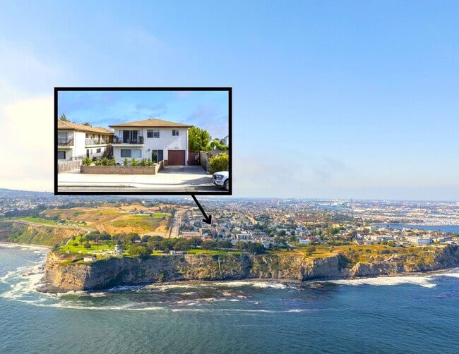

This Property Is For Sale
NEARBY LISTINGS FOR SALE OR LEASE
-
-
-
-
No Photo
-
-
-
-
View all San Pedro listings for sale on LoopNet.com
Property Detail
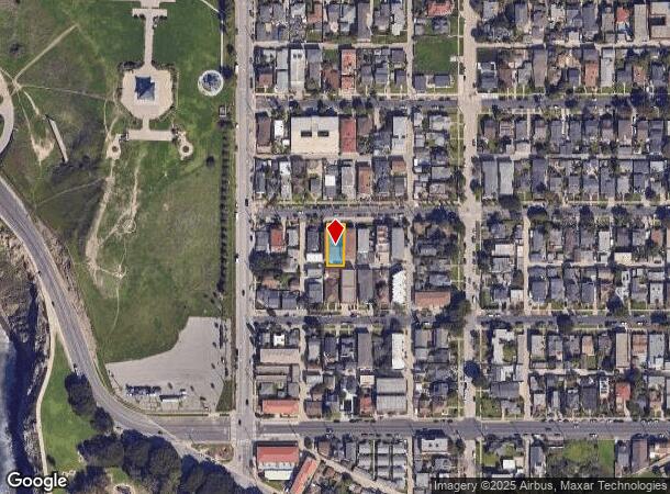
721 W 39Th St
Los Angeles-Long Beach-Glendale, CA
Pecks Ocean View Tract
7467-021-002
PECKS OCEAN VIEW TRACT LOT 2 BLK 9
Multifamilydwelling
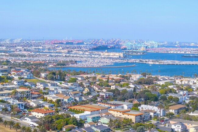
Los Angeles
X
California
06037C2033G
2
2024
0.14 AC
2025
Coastal San Pedro
297601
Los Angeles
5,384 SF
DEMOGRAPHICS near 721 W 39Th St
1 Mile
3 Mile
5 Mile
2024 Total Population
11,437
71,754
108,264
2029 Population
11,232
69,804
105,229
Pop Growth 2024-2029
(1.79%)
(2.72%)
(2.80%)
Average Age
42
41
41
2024 Total Households
4,941
27,455
39,768
HH Growth 2024-2029
(2.27%)
(2.94%)
(3.07%)
Median Household Inc
$79,365
$72,752
$83,356
Avg Household Size
2.20
2.50
2.60
2024 Avg HH Vehicles
2.00
2.00
2.00
Median Home Value
$789,451
$793,505
$844,082
Median Year Built
1959
1959
1964
Nearby Places
Map Layers
Map Styles
 Street
 Aerial
- Restaurants
- Banks
- Shops
- Fitness
- Groceries
PUBLIC TRANSPORTATION
AIRPORT
Long Beach (Daugherty Field)
DRIVE
WALK
Distance
Long Beach (Daugherty Field)
26 min
15.7 mi
Los Angeles International
DRIVE
WALK
Distance
Los Angeles International
32 min
22.6 mi
Freight Ports
Port of Los Angeles
DRIVE
WALK
Distance
Port of Los Angeles
17 min
6.8 mi
Nearby Properties
Address
Land Use
TOTAL SIZE
Lot Size
Zoning
Address
Land Use
TOTAL SIZE
Lot Size
Zoning
414,189 SF
2.45 AC
LAC2
Address
Land Use
TOTAL SIZE
Lot Size
Zoning
173,135 SF
2.05 AC
LAC2
Address
Land Use
TOTAL SIZE
Lot Size
Zoning
145,530 SF
5.22 AC
LARD2
Address
Land Use
TOTAL SIZE
Lot Size
Zoning
488,488 SF
1.65 AC
LAC2
Address
Land Use
TOTAL SIZE
Lot Size
Zoning
202,544 SF
3.59 AC
LCC3*
Address
Land Use
TOTAL SIZE
Lot Size
Zoning
55,726 SF
1.01 AC
LAC2
Address
Land Use
TOTAL SIZE
Lot Size
Zoning
72,960 SF
1.63 AC
LAC2
Address
Land Use
TOTAL SIZE
Lot Size
Zoning
5,484 SF
3.42 AC
LARD1.5
Address
Land Use
TOTAL SIZE
Lot Size
Zoning
4,570 SF
4.03 AC
LAR4
Address
Land Use
TOTAL SIZE
Lot Size
Zoning
23,000 SF
0.60 AC
LAC2
Address
Land Use
TOTAL SIZE
Lot Size
Zoning
135,389 SF
1.88 AC
LAR4
Address
Land Use
TOTAL SIZE
Lot Size
Zoning
121.07 AC
LAM3
Address
Land Use
TOTAL SIZE
Lot Size
Zoning
142,587 SF
Address
Land Use
TOTAL SIZE
Lot Size
Zoning
52,317 SF
0.68 AC
LARD2
Address
Land Use
TOTAL SIZE
Lot Size
Zoning
4,169 SF
0.76 AC
LAC2
Address
Land Use
TOTAL SIZE
Lot Size
Zoning
212,700 SF
5.39 AC
LAC2
Address
Land Use
TOTAL SIZE
Lot Size
Zoning
40,576 SF
0.67 AC
LAC2
Address
Land Use
TOTAL SIZE
Lot Size
Zoning
64,873 SF
0.87 AC
LAC2
Address
Land Use
TOTAL SIZE
Lot Size
Zoning
60,840 SF
1.59 AC
LAR3
Address
Land Use
TOTAL SIZE
Lot Size
Zoning
34,651 SF
0.62 AC
LARD2
Address
Land Use
TOTAL SIZE
Lot Size
Zoning
62,079 SF
1.14 AC
LAR4
Address
Land Use
TOTAL SIZE
Lot Size
Zoning
63,354 SF
0.77 AC
LAR4
Address
Land Use
TOTAL SIZE
Lot Size
Zoning
20 AC
LAR1
Address
Land Use
TOTAL SIZE
Lot Size
Zoning
14,472 SF
0.76 AC
LAC2
Address
Land Use
TOTAL SIZE
Lot Size
Zoning
126.70 AC
LAR1
Address
Land Use
TOTAL SIZE
Lot Size
Zoning
33,012 SF
1.57 AC
LARD6
Address
Land Use
TOTAL SIZE
Lot Size
Zoning
112,667 SF
1.23 AC
LAC2
Address
Land Use
TOTAL SIZE
Lot Size
Zoning
32,977 SF
0.49 AC
LARD2
Address
Land Use
TOTAL SIZE
Lot Size
Zoning
73,985 SF
0.88 AC
LAC2
The World's #1 Commercial Real Estate Marketplace
Connect with us
© 2025 CoStar Group
The information above has been obtained from sources believed reliable. While we do not doubt its accuracy we have not verified it and make no guarantee, warranty or representation about it. It is your responsibility to independently confirm its accuracy and completeness. Any projections, opinions, assumptions, or estimates used are for example only and do not represent the current or future performance of the property. The value of this transaction to you depends on tax and other factors which should be evaluated by your tax, financial, and legal advisors. You and your advisors should conduct a careful, independent investigation of the property to determine to your satisfaction the suitability of the property for your needs.