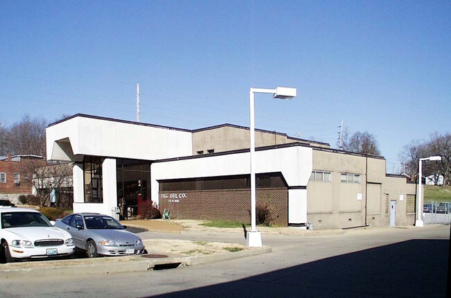
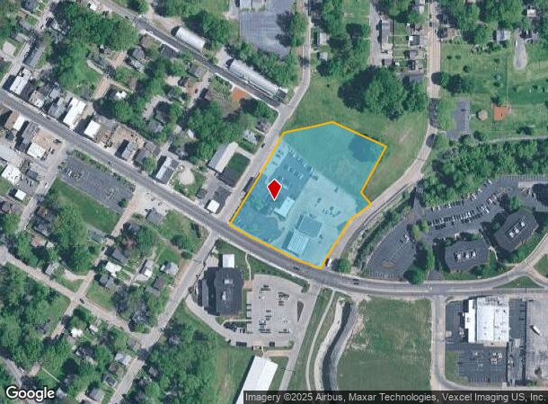
Property Record
721 W Main St, Belleville, IL 62220
NEARBY LISTINGS FOR SALE OR LEASE
Property Detail
721 W Main St
St. Louis
& Switzers Addition
St. Louis, MO-IL
WEST BELLEVILLE LOT/SEC-585 ALL LOT 584 & EXC PT TO CITY IN 882-264 LOT 585 & SWITZERS ADDITION PT AS IN 883 -159 LOT 7-A & E
08-21.0-331-009
St. Clair
Industrialgeneral
Illinois
2024
7,584
2024
3.57 AC
501700
Illinois
10,045 SF
DEMOGRAPHICS near 721 W Main St
1 Mile
3 Mile
5 Mile
2024 Total Population
9,980
48,211
87,844
2029 Population
9,864
46,752
84,962
Pop Growth 2024-2029
(1.16%)
(3.03%)
(3.28%)
Average Age
40
41
41
2024 Total Households
4,001
20,801
37,082
HH Growth 2024-2029
(0.97%)
(3.00%)
(3.28%)
Median Household Inc
$56,328
$64,301
$72,691
Avg Household Size
2.10
2.20
2.30
2024 Avg HH Vehicles
1.00
2.00
2.00
Median Home Value
$77,840
$127,098
$161,790
Median Year Built
1947
1964
1974
Nearby Places
Map Layers
Map Styles
 Street
 Aerial
- Restaurants
- Banks
- Shops
- Fitness
- Groceries
PUBLIC TRANSPORTATION
COMMUTER RAIL
Belleville (Lambert Airport Shiloh-Scott - St. Louis MetroLink (MetroLink))
DRIVE
WALK
Distance
Belleville (Lambert Airport Shiloh-Scott - St. Louis MetroLink (MetroLink))
5 min
1.9 mi
Swansea (Lambert Airport Shiloh-Scott - St. Louis MetroLink (MetroLink))
DRIVE
WALK
Distance
Swansea (Lambert Airport Shiloh-Scott - St. Louis MetroLink (MetroLink))
6 min
2.6 mi
AIRPORT
Scott AFB/Midamerica St Louis
DRIVE
WALK
Distance
Scott AFB/Midamerica St Louis
23 min
11.6 mi
St Louis Lambert International
DRIVE
WALK
Distance
St Louis Lambert International
42 min
28.6 mi
Nearby Properties
Address
Land Use
TOTAL SIZE
Lot Size
Zoning
Address
Land Use
TOTAL SIZE
Lot Size
Zoning
20,522 SF
6.42 AC
Address
Land Use
TOTAL SIZE
Lot Size
Zoning
41,366 SF
12.07 AC
Address
Land Use
TOTAL SIZE
Lot Size
Zoning
127,590 SF
10.53 AC
Address
Land Use
TOTAL SIZE
Lot Size
Zoning
18,734 SF
10.48 AC
Address
Land Use
TOTAL SIZE
Lot Size
Zoning
104,230 SF
11.08 AC
Address
Land Use
TOTAL SIZE
Lot Size
Zoning
Address
Land Use
TOTAL SIZE
Lot Size
Zoning
126,937 SF
11.98 AC
Address
Land Use
TOTAL SIZE
Lot Size
Zoning
10,505 SF
20.08 AC
Address
Land Use
TOTAL SIZE
Lot Size
Zoning
6,800 SF
4.33 AC
Address
Land Use
TOTAL SIZE
Lot Size
Zoning
13,546 SF
11.19 AC
Address
Land Use
TOTAL SIZE
Lot Size
Zoning
86,482 SF
8 AC
Address
Land Use
TOTAL SIZE
Lot Size
Zoning
15,839 SF
5.96 AC
Address
Land Use
TOTAL SIZE
Lot Size
Zoning
26,233 SF
17.61 AC
Address
Land Use
TOTAL SIZE
Lot Size
Zoning
16,549 SF
5.44 AC
Address
Land Use
TOTAL SIZE
Lot Size
Zoning
54,179 SF
9.26 AC
Address
Land Use
TOTAL SIZE
Lot Size
Zoning
88,468 SF
10.48 AC
Address
Land Use
TOTAL SIZE
Lot Size
Zoning
4.70 AC
Address
Land Use
TOTAL SIZE
Lot Size
Zoning
4,818 SF
3.64 AC
Address
Land Use
TOTAL SIZE
Lot Size
Zoning
15,480 SF
1.35 AC
Address
Land Use
TOTAL SIZE
Lot Size
Zoning
23,951 SF
0.89 AC
Address
Land Use
TOTAL SIZE
Lot Size
Zoning
4,400 SF
2.56 AC
Address
Land Use
TOTAL SIZE
Lot Size
Zoning
30,000 SF
9.05 AC
Address
Land Use
TOTAL SIZE
Lot Size
Zoning
8,208 SF
1.58 AC
Address
Land Use
TOTAL SIZE
Lot Size
Zoning
38,259 SF
7.80 AC
Address
Land Use
TOTAL SIZE
Lot Size
Zoning
12,010 SF
2.49 AC
Address
Land Use
TOTAL SIZE
Lot Size
Zoning
47,369 SF
4.17 AC
Address
Land Use
TOTAL SIZE
Lot Size
Zoning
12.99 AC
Address
Land Use
TOTAL SIZE
Lot Size
Zoning
45,394 SF
4.13 AC
Address
Land Use
TOTAL SIZE
Lot Size
Zoning
36,445 SF
6.07 AC
Address
Land Use
TOTAL SIZE
Lot Size
Zoning
5,872 SF
1.15 AC
The World's #1 Commercial Real Estate Marketplace
Connect with us
© 2025 CoStar Group
The information above has been obtained from sources believed reliable. While we do not doubt its accuracy we have not verified it and make no guarantee, warranty or representation about it. It is your responsibility to independently confirm its accuracy and completeness. Any projections, opinions, assumptions, or estimates used are for example only and do not represent the current or future performance of the property. The value of this transaction to you depends on tax and other factors which should be evaluated by your tax, financial, and legal advisors. You and your advisors should conduct a careful, independent investigation of the property to determine to your satisfaction the suitability of the property for your needs.