Property Record
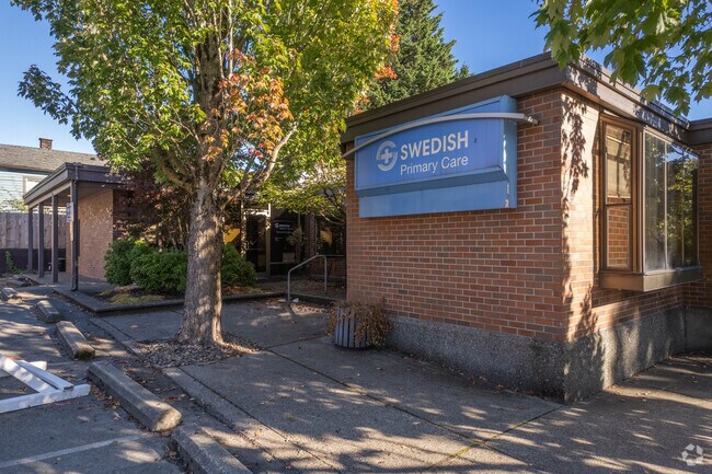
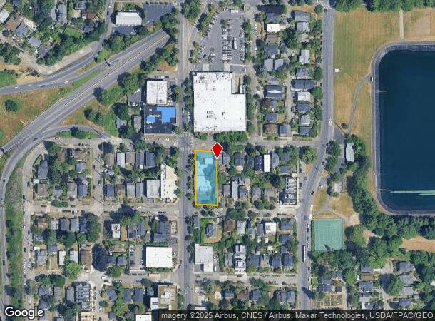
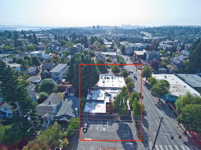
7210 Roosevelt Way Ne, Seattle, WA 98115

NEARBY LISTINGS FOR SALE OR LEASE
Property Detail
7210 Roosevelt Way Ne
Seattle-Tacoma-Bellevue, WA
Perkins Green Lake Add
671670-0330
PERKINS GREEN LAKE ADD
Medicalbuilding
King
X
Washington
53033C0340G
11-16
2025
0.37 AC
2024
Ballard/U Dist
002600
Seattle/Puget Sound
7,091 SF
DEMOGRAPHICS near 7210 Roosevelt Way Ne
1 Mile
3 Mile
5 Mile
2024 Total Population
36,194
249,302
537,433
2029 Population
36,747
251,837
544,564
Pop Growth 2024-2029
+ 1.53%
+ 1.02%
+ 1.33%
Average Age
37
37
38
2024 Total Households
16,272
110,351
261,618
HH Growth 2024-2029
+ 1.78%
+ 1.05%
+ 1.40%
Median Household Inc
$122,544
$114,329
$116,690
Avg Household Size
2.10
2.10
1.90
2024 Avg HH Vehicles
1.00
1.00
1.00
Median Home Value
$986,064
$926,545
$934,855
Median Year Built
1966
1969
1977
Nearby Places
Map Layers
Map Styles
 Street
 Aerial
- Restaurants
- Banks
- Shops
- Fitness
- Groceries
PUBLIC TRANSPORTATION
TRANSIT/SUBWAY
Roosevelt Station (Lynnwood - Angle Lake - Sound Transit, Northgate - Angle Lake - Sound Transit)
DRIVE
WALK
Distance
Roosevelt Station (Lynnwood - Angle Lake - Sound Transit, Northgate - Angle Lake - Sound Transit)
2 min
8 min
0.4 mi
COMMUTER RAIL
King Street (Seattle) Station (Everett - Seattle - Sound Transit, Seattle - Tacoma/Lakewood - Sound Transit, Sounder South Line - Sound Transit)
DRIVE
WALK
Distance
King Street (Seattle) Station (Everett - Seattle - Sound Transit, Seattle - Tacoma/Lakewood - Sound Transit, Sounder South Line - Sound Transit)
11 min
6.5 mi
AIRPORT
Seattle Paine Field International
DRIVE
WALK
Distance
Seattle Paine Field International
28 min
18.7 mi
Seattle-Tacoma International
DRIVE
WALK
Distance
Seattle-Tacoma International
30 min
19.8 mi
Freight Ports
Port of Seattle
DRIVE
WALK
Distance
Port of Seattle
17 min
10.3 mi
SALE & LEASE HISTORY
LISTING DATE
SALE/LEASE

Oct 17, 2023
For Sale
Feb 16, 2021
For Lease
Feb 16, 2021
For Sale
Nearby Properties
Address
Land Use
TOTAL SIZE
Lot Size
Zoning
Address
Land Use
TOTAL SIZE
Lot Size
Zoning
471.20 AC
MIO-37-LR1
Address
Land Use
TOTAL SIZE
Lot Size
Zoning
26,850 SF
194.66 AC
NR2
Address
Land Use
TOTAL SIZE
Lot Size
Zoning
107.86 AC
NR2
Address
Land Use
TOTAL SIZE
Lot Size
Zoning
50,060 SF
96.12 AC
NR2
Address
Land Use
TOTAL SIZE
Lot Size
Zoning
7,549 SF
59.34 AC
MIO-105-LR
Address
Land Use
TOTAL SIZE
Lot Size
Zoning
612,844 SF
0.09 AC
SM-U/R 75-
Address
Land Use
TOTAL SIZE
Lot Size
Zoning
90,184 SF
16.66 AC
C1-75 (M)
Address
Land Use
TOTAL SIZE
Lot Size
Zoning
107.93 AC
NR3
Address
Land Use
TOTAL SIZE
Lot Size
Zoning
42,500 SF
90.92 AC
NR3
Address
Land Use
TOTAL SIZE
Lot Size
Zoning
241,955 SF
12.81 AC
LR2 (M)
Address
Land Use
TOTAL SIZE
Lot Size
Zoning
301,245 SF
22.34 AC
LR3 (M)
Address
Land Use
TOTAL SIZE
Lot Size
Zoning
25,735 SF
1.56 AC
C1-75 (M)
Address
Land Use
TOTAL SIZE
Lot Size
Zoning
20,289 SF
10.76 AC
MIO-50-LR3
Address
Land Use
TOTAL SIZE
Lot Size
Zoning
210,103 SF
1.03 AC
NC3P-95 (M
Address
Land Use
TOTAL SIZE
Lot Size
Zoning
285,140 SF
0.90 AC
NC2-75 (M1
Address
Land Use
TOTAL SIZE
Lot Size
Zoning
131,790 SF
0.37 AC
SM-U 75-24
Address
Land Use
TOTAL SIZE
Lot Size
Zoning
6.87 AC
MIO-200-C1
Address
Land Use
TOTAL SIZE
Lot Size
Zoning
126,394 SF
8.80 AC
C2-75 (M)
Address
Land Use
TOTAL SIZE
Lot Size
Zoning
223,047 SF
0.18 AC
NC2P-75 (M
Address
Land Use
TOTAL SIZE
Lot Size
Zoning
382,762 SF
7.14 AC
NR3
Address
Land Use
TOTAL SIZE
Lot Size
Zoning
172,297 SF
4.21 AC
NC3-95 (M)
Address
Land Use
TOTAL SIZE
Lot Size
Zoning
0.31 AC
SM-U 95-32
Address
Land Use
TOTAL SIZE
Lot Size
Zoning
10,090 SF
11.73 AC
NC3-95 (M)
Address
Land Use
TOTAL SIZE
Lot Size
Zoning
132,183 SF
0.76 AC
NC2-65
Address
Land Use
TOTAL SIZE
Lot Size
Zoning
1,100 SF
18.83 AC
UI U/45
Address
Land Use
TOTAL SIZE
Lot Size
Zoning
6,534 SF
0.55 AC
IC-65 (M)
Address
Land Use
TOTAL SIZE
Lot Size
Zoning
336,323 SF
1.67 AC
IC-65 (M)
Address
Land Use
TOTAL SIZE
Lot Size
Zoning
196,820 SF
0.64 AC
NC3P-95 (M
The World's #1 Commercial Real Estate Marketplace
Connect with us
© 2025 CoStar Group
The information above has been obtained from sources believed reliable. While we do not doubt its accuracy we have not verified it and make no guarantee, warranty or representation about it. It is your responsibility to independently confirm its accuracy and completeness. Any projections, opinions, assumptions, or estimates used are for example only and do not represent the current or future performance of the property. The value of this transaction to you depends on tax and other factors which should be evaluated by your tax, financial, and legal advisors. You and your advisors should conduct a careful, independent investigation of the property to determine to your satisfaction the suitability of the property for your needs.