Property Record
7211 Spindle Dr, Houston, TX 77086


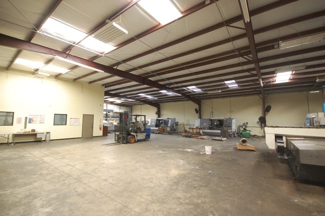
This Property Is For Sale
Current Lease Availabilities
Property Detail
7211 Spindle Dr
Houston-Pasadena-The Woodlands, TX
LT 3 BLK 4 RECREATION FARMS SEC 1 ABST 222 T M DORSETT
0420760010045
HARRIS
Outdoorrecreationbeachmountaindesert
Texas
B and X Area of moderate flood hazard, usually the area between the limits of the 100-year and 500-year floods.
3
2024
0.97 AC
2025
Hwy 290/Tomball Pky
534001
Houston
8,000 SF
NEARBY LISTINGS FOR SALE OR LEASE
DEMOGRAPHICS near 7211 Spindle Dr
1 mile
3 mile
5 mile
2025 Total Population
7,781
115,151
299,362
2030 Population
8,195
121,210
316,899
Pop Growth 2025-2030
+ 5.32%
+ 5.26%
+ 5.86%
Average Age
37
36
37
2025 Total Households
2,290
35,372
97,371
HH Growth 2025-2030
+ 5.55%
+ 5.36%
+ 6.05%
Median Household Inc
$64,172
$64,990
$61,277
Avg Household Size
3.40
3.20
3.00
2025 Avg HH Vehicles
2.00
2.00
2.00
Median Home Value
$192,280
$226,042
$231,642
Median Year Built
1977
1985
1985
Nearby Places
Map Layers
Map Styles
 Street
 Aerial
Layers
 Traffic
 Biking
Places
Listings with unknown addresses are not visible on the map
- Restaurants
- Banks
- Shops
- Fitness
- Groceries
PUBLIC TRANSPORTATION
AIRPORT
George Bush Intcntl/Houston
Drive
Walk
Distance
George Bush Intcntl/Houston
21 min
15.7 mi
William P Hobby
Drive
Walk
Distance
William P Hobby
45 min
27.4 mi
Freight Ports
Port of Houston
Drive
Walk
Distance
Port of Houston
37 min
24.7 mi
Nearby Properties
Address
Land Use
TOTAL SIZE
Lot Size
Zoning
Address
Land Use
TOTAL SIZE
Lot Size
Zoning
552,757 SF
32.95 AC
Address
Land Use
TOTAL SIZE
Lot Size
Zoning
527,744 SF
35.46 AC
Address
Land Use
TOTAL SIZE
Lot Size
Zoning
397,248 SF
26.37 AC
Address
Land Use
TOTAL SIZE
Lot Size
Zoning
456,294 SF
19.02 AC
Address
Land Use
TOTAL SIZE
Lot Size
Zoning
365,380 SF
19.17 AC
Address
Land Use
TOTAL SIZE
Lot Size
Zoning
495,024 SF
23.96 AC
Address
Land Use
TOTAL SIZE
Lot Size
Zoning
502,860 SF
40.99 AC
Address
Land Use
TOTAL SIZE
Lot Size
Zoning
399,828 SF
20.32 AC
Address
Land Use
TOTAL SIZE
Lot Size
Zoning
424,122 SF
21.06 AC
Address
Land Use
TOTAL SIZE
Lot Size
Zoning
361,800 SF
18.20 AC
Address
Land Use
TOTAL SIZE
Lot Size
Zoning
447,480 SF
18.48 AC
Address
Land Use
TOTAL SIZE
Lot Size
Zoning
357,300 SF
23.38 AC
Address
Land Use
TOTAL SIZE
Lot Size
Zoning
297,351 SF
13.47 AC
Address
Land Use
TOTAL SIZE
Lot Size
Zoning
215,968 SF
17.23 AC
Address
Land Use
TOTAL SIZE
Lot Size
Zoning
356,656 SF
23.54 AC
Address
Land Use
TOTAL SIZE
Lot Size
Zoning
292,112 SF
4.41 AC
Address
Land Use
TOTAL SIZE
Lot Size
Zoning
299,640 SF
13.95 AC
Address
Land Use
TOTAL SIZE
Lot Size
Zoning
200,123 SF
14.94 AC
Address
Land Use
TOTAL SIZE
Lot Size
Zoning
614,712 SF
7.93 AC
Address
Land Use
TOTAL SIZE
Lot Size
Zoning
241,190 SF
13.98 AC
Address
Land Use
TOTAL SIZE
Lot Size
Zoning
352,680 SF
28.21 AC
Address
Land Use
TOTAL SIZE
Lot Size
Zoning
252,080 SF
13.92 AC
Address
Land Use
TOTAL SIZE
Lot Size
Zoning
287,510 SF
19.43 AC
Address
Land Use
TOTAL SIZE
Lot Size
Zoning
201,947 SF
8.80 AC
Address
Land Use
TOTAL SIZE
Lot Size
Zoning
253,369 SF
16.81 AC
Address
Land Use
TOTAL SIZE
Lot Size
Zoning
209,825 SF
11.97 AC
Address
Land Use
TOTAL SIZE
Lot Size
Zoning
523,507 SF
38.28 AC
Address
Land Use
TOTAL SIZE
Lot Size
Zoning
397,012 SF
35.38 AC
Address
Land Use
TOTAL SIZE
Lot Size
Zoning
232,702 SF
14.75 AC
Address
Land Use
TOTAL SIZE
Lot Size
Zoning
194,196 SF
62.19 AC
The World's #1 Commercial Real Estate Marketplace
Connect with us
© 2026 CoStar Group
The information above has been obtained from sources believed reliable. While we do not doubt its accuracy we have not verified it and make no guarantee, warranty or representation about it. It is your responsibility to independently confirm its accuracy and completeness. Any projections, opinions, assumptions, or estimates used are for example only and do not represent the current or future performance of the property. The value of this transaction to you depends on tax and other factors which should be evaluated by your tax, financial, and legal advisors. You and your advisors should conduct a careful, independent investigation of the property to determine to your satisfaction the suitability of the property for your needs.