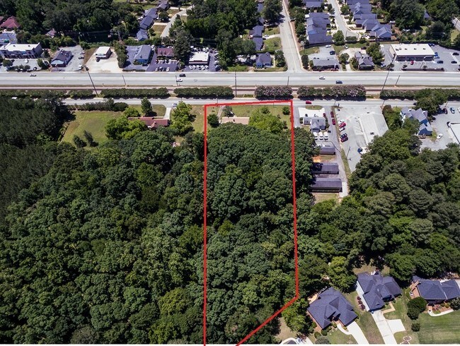
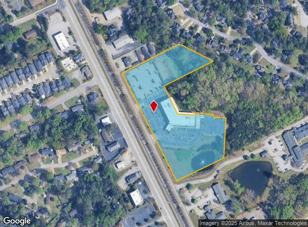
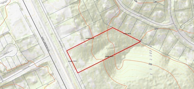
Property Record
7212 Woodrow St, Irmo, SC 29063
NEARBY LISTINGS FOR SALE OR LEASE
Property Detail
7212 Woodrow St
001922-10-003
TRACT A
Medicalbuilding
Lexington
X
South Carolina
45063C0133J
2-3
2025
6.84 AC
2024
Dutch Fork/Irmo
021112
Columbia
43,316 SF
Columbia, SC
DEMOGRAPHICS near 7212 Woodrow St
1 Mile
3 Mile
5 Mile
2024 Total Population
7,206
45,380
89,329
2029 Population
7,681
47,575
93,396
Pop Growth 2024-2029
+ 6.59%
+ 4.84%
+ 4.55%
Average Age
43
41
40
2024 Total Households
3,076
19,157
35,406
HH Growth 2024-2029
+ 6.73%
+ 4.89%
+ 4.89%
Median Household Inc
$74,631
$69,760
$68,024
Avg Household Size
2.30
2.30
2.40
2024 Avg HH Vehicles
2.00
2.00
2.00
Median Home Value
$204,032
$179,659
$197,984
Median Year Built
1984
1986
1986
Nearby Places
Map Layers
Map Styles
 Street
 Aerial
- Restaurants
- Banks
- Shops
- Fitness
- Groceries
PUBLIC TRANSPORTATION
AIRPORT
Columbia Metro
DRIVE
WALK
Distance
Columbia Metro
30 min
16.6 mi
Freight Ports
North Charleston Terminal
DRIVE
WALK
Distance
North Charleston Terminal
130 min
112.9 mi
SALE & LEASE HISTORY
LISTING DATE
SALE/LEASE

May 24, 2017
For Sale
Jan 26, 2017
For Sale
Aug 14, 2017
For Sale
Nearby Properties
Address
Land Use
TOTAL SIZE
Lot Size
Zoning
Address
Land Use
TOTAL SIZE
Lot Size
Zoning
24.90 AC
PD
Address
Land Use
TOTAL SIZE
Lot Size
Zoning
370,876 SF
14.43 AC
PD
Address
Land Use
TOTAL SIZE
Lot Size
Zoning
302,835 SF
11.48 AC
PD
Address
Land Use
TOTAL SIZE
Lot Size
Zoning
241,756 SF
14.25 AC
PD
Address
Land Use
TOTAL SIZE
Lot Size
Zoning
1,549.59 AC
T/C
Address
Land Use
TOTAL SIZE
Lot Size
Zoning
215,796 SF
12.71 AC
PD
Address
Land Use
TOTAL SIZE
Lot Size
Zoning
73,380 SF
16.07 AC
PDD
Address
Land Use
TOTAL SIZE
Lot Size
Zoning
159,139 SF
16.95 AC
GC
Address
Land Use
TOTAL SIZE
Lot Size
Zoning
146,254 SF
12.12 AC
PD
Address
Land Use
TOTAL SIZE
Lot Size
Zoning
126,596 SF
10.84 AC
PD
Address
Land Use
TOTAL SIZE
Lot Size
Zoning
86,542 SF
3.25 AC
PD
Address
Land Use
TOTAL SIZE
Lot Size
Zoning
88,284 SF
0.78 AC
PD
Address
Land Use
TOTAL SIZE
Lot Size
Zoning
81,197 SF
10.34 AC
C-3
Address
Land Use
TOTAL SIZE
Lot Size
Zoning
153,210 SF
31.78 AC
LM
Address
Land Use
TOTAL SIZE
Lot Size
Zoning
87,200 SF
7 AC
PDD
Address
Land Use
TOTAL SIZE
Lot Size
Zoning
187,298 SF
9.11 AC
PD
Address
Land Use
TOTAL SIZE
Lot Size
Zoning
136,641 SF
9 AC
PDD
Address
Land Use
TOTAL SIZE
Lot Size
Zoning
32.33 AC
PD
Address
Land Use
TOTAL SIZE
Lot Size
Zoning
61,333 SF
3.23 AC
PD
Address
Land Use
TOTAL SIZE
Lot Size
Zoning
70,390 SF
12.76 AC
CAC
Address
Land Use
TOTAL SIZE
Lot Size
Zoning
77,644 SF
2.59 AC
PD
Address
Land Use
TOTAL SIZE
Lot Size
Zoning
75,358 SF
13.84 AC
M-1
Address
Land Use
TOTAL SIZE
Lot Size
Zoning
66,351 SF
2.20 AC
PD
Address
Land Use
TOTAL SIZE
Lot Size
Zoning
100,797 SF
3.90 AC
PDD
Address
Land Use
TOTAL SIZE
Lot Size
Zoning
8,358 SF
9.12 AC
CG
Address
Land Use
TOTAL SIZE
Lot Size
Zoning
243,045 SF
12.97 AC
PD
Address
Land Use
TOTAL SIZE
Lot Size
Zoning
76,204 SF
2.26 AC
CN
Address
Land Use
TOTAL SIZE
Lot Size
Zoning
69,982 SF
4.32 AC
PDD
Address
Land Use
TOTAL SIZE
Lot Size
Zoning
66,612 SF
5.56 AC
CG
Address
Land Use
TOTAL SIZE
Lot Size
Zoning
54,842 SF
1.73 AC
PD
The World's #1 Commercial Real Estate Marketplace
Connect with us
© 2026 CoStar Group
The information above has been obtained from sources believed reliable. While we do not doubt its accuracy we have not verified it and make no guarantee, warranty or representation about it. It is your responsibility to independently confirm its accuracy and completeness. Any projections, opinions, assumptions, or estimates used are for example only and do not represent the current or future performance of the property. The value of this transaction to you depends on tax and other factors which should be evaluated by your tax, financial, and legal advisors. You and your advisors should conduct a careful, independent investigation of the property to determine to your satisfaction the suitability of the property for your needs.