Property Record
7213 Sw 44Th Pl, Gainesville, FL 32608
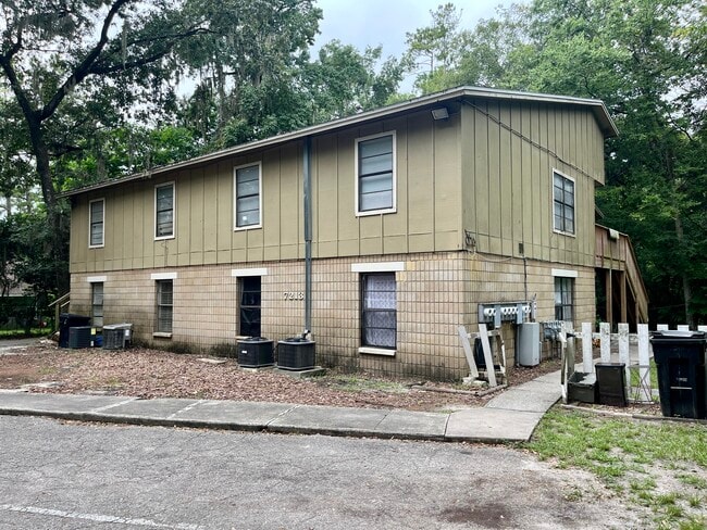

This Property Is For Sale
NEARBY LISTINGS FOR SALE OR LEASE
Property Detail
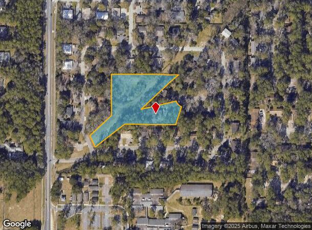
7213 Sw 44Th Pl
Gainesville, FL
Tower Village Iii
06879-010-030
TOWER VILLAGE III PB K-58 LOT 30 & 2/38 INT COM AREA OR 4653/1220
Multifamilydwelling
Alachua
A
Florida
12001C0435E
30,2
2025
0.87 AC
2025
West Gainesville
002219
Other Market Areas
6,144 SF
DEMOGRAPHICS near 7213 Sw 44Th Pl
1 Mile
3 Mile
5 Mile
2024 Total Population
8,223
56,775
119,064
2029 Population
8,723
60,143
125,149
Pop Growth 2024-2029
+ 6.08%
+ 5.93%
+ 5.11%
Average Age
39
35
36
2024 Total Households
3,365
23,231
48,884
HH Growth 2024-2029
+ 6.39%
+ 6.08%
+ 5.15%
Median Household Inc
$69,074
$60,343
$57,918
Avg Household Size
2.40
2.30
2.30
2024 Avg HH Vehicles
2.00
2.00
2.00
Median Home Value
$310,332
$329,689
$313,898
Median Year Built
1994
1993
1991
Nearby Places
Map Layers
Map Styles
 Street
 Aerial
- Restaurants
- Banks
- Shops
- Fitness
- Groceries
PUBLIC TRANSPORTATION
AIRPORT
Gainesville Regional
DRIVE
WALK
Distance
Gainesville Regional
30 min
13.8 mi
Freight Ports
Jacksonville Port
DRIVE
WALK
Distance
Jacksonville Port
116 min
83.6 mi
Nearby Properties
Address
Land Use
TOTAL SIZE
Lot Size
Zoning
Address
Land Use
TOTAL SIZE
Lot Size
Zoning
571,635 SF
55.49 AC
RMF6
Address
Land Use
TOTAL SIZE
Lot Size
Zoning
392,241 SF
25 AC
U9
Address
Land Use
TOTAL SIZE
Lot Size
Zoning
318,578 SF
21.24 AC
RMF7
Address
Land Use
TOTAL SIZE
Lot Size
Zoning
495,440 SF
14.88 AC
U9
Address
Land Use
TOTAL SIZE
Lot Size
Zoning
337,105 SF
7.87 AC
MU1
Address
Land Use
TOTAL SIZE
Lot Size
Zoning
299,984 SF
10.33 AC
MU2
Address
Land Use
TOTAL SIZE
Lot Size
Zoning
366,764 SF
26.03 AC
RMF6
Address
Land Use
TOTAL SIZE
Lot Size
Zoning
170,185 SF
5.14 AC
R-1AA
Address
Land Use
TOTAL SIZE
Lot Size
Zoning
484,466 SF
7.44 AC
U9
Address
Land Use
TOTAL SIZE
Lot Size
Zoning
371,933 SF
15 AC
PD
Address
Land Use
TOTAL SIZE
Lot Size
Zoning
230,564 SF
6.34 AC
U9
Address
Land Use
TOTAL SIZE
Lot Size
Zoning
332,878 SF
34.15 AC
PD
Address
Land Use
TOTAL SIZE
Lot Size
Zoning
344,284 SF
31.74 AC
PD
Address
Land Use
TOTAL SIZE
Lot Size
Zoning
228,729 SF
8.10 AC
U9
Address
Land Use
TOTAL SIZE
Lot Size
Zoning
440,687 SF
33.32 AC
RMF8
Address
Land Use
TOTAL SIZE
Lot Size
Zoning
214,608 SF
21.23 AC
MU2
Address
Land Use
TOTAL SIZE
Lot Size
Zoning
205,916 SF
9.89 AC
U9
Address
Land Use
TOTAL SIZE
Lot Size
Zoning
354,707 SF
25.98 AC
RMF8
Address
Land Use
TOTAL SIZE
Lot Size
Zoning
232,629 SF
22.60 AC
U9
Address
Land Use
TOTAL SIZE
Lot Size
Zoning
205,412 SF
23.80 AC
R-1A
Address
Land Use
TOTAL SIZE
Lot Size
Zoning
309,967 SF
12.58 AC
PD
Address
Land Use
TOTAL SIZE
Lot Size
Zoning
134,068 SF
3.47 AC
R-2
Address
Land Use
TOTAL SIZE
Lot Size
Zoning
311,673 SF
34.15 AC
R-2
Address
Land Use
TOTAL SIZE
Lot Size
Zoning
216,826 SF
17.91 AC
PD
Address
Land Use
TOTAL SIZE
Lot Size
Zoning
272,406 SF
25.39 AC
PD
Address
Land Use
TOTAL SIZE
Lot Size
Zoning
307,316 SF
25.99 AC
R-2
Address
Land Use
TOTAL SIZE
Lot Size
Zoning
296,660 SF
21.78 AC
R-3
Address
Land Use
TOTAL SIZE
Lot Size
Zoning
29,190 SF
4.21 AC
BI
Address
Land Use
TOTAL SIZE
Lot Size
Zoning
172,598 SF
23.13 AC
U9
Address
Land Use
TOTAL SIZE
Lot Size
Zoning
232,380 SF
37.50 AC
PD
The World's #1 Commercial Real Estate Marketplace
Connect with us
© 2026 CoStar Group
The information above has been obtained from sources believed reliable. While we do not doubt its accuracy we have not verified it and make no guarantee, warranty or representation about it. It is your responsibility to independently confirm its accuracy and completeness. Any projections, opinions, assumptions, or estimates used are for example only and do not represent the current or future performance of the property. The value of this transaction to you depends on tax and other factors which should be evaluated by your tax, financial, and legal advisors. You and your advisors should conduct a careful, independent investigation of the property to determine to your satisfaction the suitability of the property for your needs.