Property Record
929 Sw University Blvd, Topeka, KS 66619
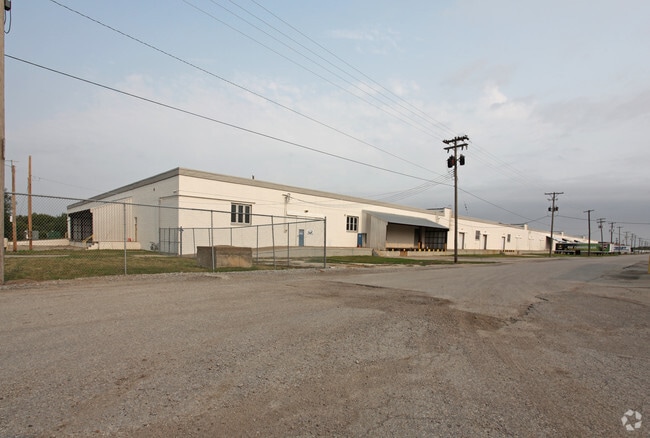
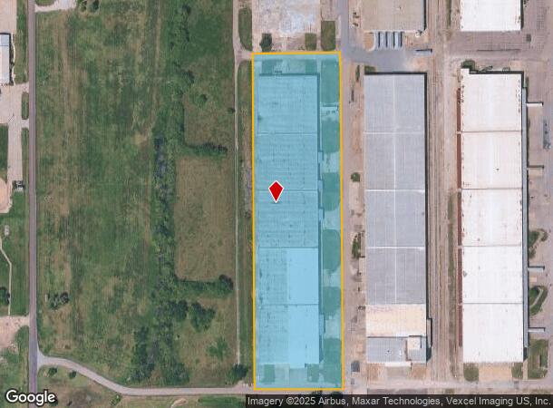

This Property Is For Sale
Current Lease Availabilities
Industrial LEASE
$2.60 SF/YR
38,800 SF
NEARBY LISTINGS FOR SALE OR LEASE
-
-
7215 SW Topeka Blvd., Bldg. 2703, Topeka, KS 66619
Topeka, KS 66619
$2.60 SF/YR
38,800 SF
Industrial
-
-
View all Topeka listings for lease on LoopNet.com
Property Detail
929 Sw University Blvd
191-01-0-00-01-007-050
S01, T13, R15, 1-13-15 TR BEG 1550 W OF SE COR SE 1/4 TH N 1135 W 310 S 1135, E 310 TO POB
Shipyard
Shawnee
X
Kansas
20177C0305E
8.41 AC
2024
Topeka
2025
Kansas City
003702
Topeka, KS
194,295 SF
DEMOGRAPHICS near 929 Sw University Blvd
1 Mile
3 Mile
5 Mile
2024 Total Population
2,923
5,118
34,200
2029 Population
2,902
5,090
33,877
Pop Growth 2024-2029
(0.72%)
(0.55%)
(0.94%)
Average Age
30
36
40
2024 Total Households
919
1,870
13,783
HH Growth 2024-2029
(0.76%)
(0.53%)
(1.00%)
Median Household Inc
$46,250
$55,369
$55,844
Avg Household Size
3.10
2.70
2.40
2024 Avg HH Vehicles
2.00
2.00
2.00
Median Home Value
$71,153
$109,559
$152,356
Median Year Built
1966
1980
1974
Nearby Places
- Restaurants
- Banks
- Shops
- Fitness
- Groceries
PUBLIC TRANSPORTATION
COMMUTER RAIL
Topeka Amtrak Station (Southwest Chief - Amtrak)
DRIVE
WALK
Distance
Topeka Amtrak Station (Southwest Chief - Amtrak)
17 min
9.1 mi
Freight Ports
Tulsa Port Of Catoosa
DRIVE
WALK
Distance
Tulsa Port Of Catoosa
268 min
218.1 mi
Nearby Properties
Address
Land Use
TOTAL SIZE
Lot Size
Zoning
Address
Land Use
TOTAL SIZE
Lot Size
Zoning
194.03 AC
I2
Address
Land Use
TOTAL SIZE
Lot Size
Zoning
42.18 AC
I2
Address
Land Use
TOTAL SIZE
Lot Size
Zoning
797,582 SF
384.32 AC
I1,I2
Address
Land Use
TOTAL SIZE
Lot Size
Zoning
577,341 SF
152.58 AC
I2
Address
Land Use
TOTAL SIZE
Lot Size
Zoning
1,351,980 SF
141.63 AC
I1
Address
Land Use
TOTAL SIZE
Lot Size
Zoning
602,448 SF
43.68 AC
I1
Address
Land Use
TOTAL SIZE
Lot Size
Zoning
1,250 SF
630.34 AC
RR1
Address
Land Use
TOTAL SIZE
Lot Size
Zoning
465,600 SF
52.91 AC
I1
Address
Land Use
TOTAL SIZE
Lot Size
Zoning
53,815 SF
15.40 AC
RR1
Address
Land Use
TOTAL SIZE
Lot Size
Zoning
188,358 SF
183.64 AC
I1,RR1
Address
Land Use
TOTAL SIZE
Lot Size
Zoning
64,248 SF
13.78 AC
RR1
Address
Land Use
TOTAL SIZE
Lot Size
Zoning
1,253,081 SF
73.17 AC
I1
Address
Land Use
TOTAL SIZE
Lot Size
Zoning
417.49 AC
RR1
Address
Land Use
TOTAL SIZE
Lot Size
Zoning
134,915 SF
20 AC
I1
Address
Land Use
TOTAL SIZE
Lot Size
Zoning
18.56 AC
I1
Address
Land Use
TOTAL SIZE
Lot Size
Zoning
144.10 AC
PUD,I1,RR1
Address
Land Use
TOTAL SIZE
Lot Size
Zoning
11,820 SF
2.75 AC
RR1
Address
Land Use
TOTAL SIZE
Lot Size
Zoning
34,744 SF
10.63 AC
I1,I2
Address
Land Use
TOTAL SIZE
Lot Size
Zoning
142.66 AC
RR1
Address
Land Use
TOTAL SIZE
Lot Size
Zoning
521,739 SF
25.22 AC
I1
Address
Land Use
TOTAL SIZE
Lot Size
Zoning
63,500 SF
1.93 AC
I1
Address
Land Use
TOTAL SIZE
Lot Size
Zoning
9.02 AC
Address
Land Use
TOTAL SIZE
Lot Size
Zoning
10,305 SF
63.93 AC
I1,RR1
Address
Land Use
TOTAL SIZE
Lot Size
Zoning
98,660 SF
13.73 AC
PUD,I1
Address
Land Use
TOTAL SIZE
Lot Size
Zoning
173.90 AC
RR1
Address
Land Use
TOTAL SIZE
Lot Size
Zoning
95,537 SF
5.68 AC
I2
Address
Land Use
TOTAL SIZE
Lot Size
Zoning
158.02 AC
RR1
Address
Land Use
TOTAL SIZE
Lot Size
Zoning
39,893 SF
1.77 AC
I1
Address
Land Use
TOTAL SIZE
Lot Size
Zoning
141,097 SF
12.01 AC
PUD,I1
Address
Land Use
TOTAL SIZE
Lot Size
Zoning
8,000 SF
5.30 AC
RR1
The World's #1 Commercial Real Estate Marketplace
Connect with us
© 2025 CoStar Group
The information above has been obtained from sources believed reliable. While we do not doubt its accuracy we have not verified it and make no guarantee, warranty or representation about it. It is your responsibility to independently confirm its accuracy and completeness. Any projections, opinions, assumptions, or estimates used are for example only and do not represent the current or future performance of the property. The value of this transaction to you depends on tax and other factors which should be evaluated by your tax, financial, and legal advisors. You and your advisors should conduct a careful, independent investigation of the property to determine to your satisfaction the suitability of the property for your needs.