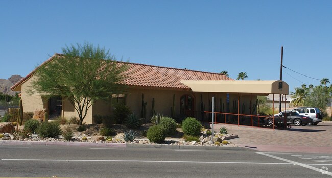
Property Record
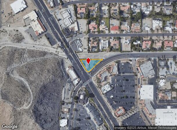
72180 Highway 111, Palm Desert, CA 92260


NEARBY LISTINGS FOR SALE OR LEASE
Property Detail
72180 Highway 111
Riverside-San Bernardino-Ontario, CA
San Bernardino Base & Meridian
640-020-009
POR SW 1/4 OF SEC 18 T5S R6E FOR TOTAL DESCRIPTION SEE ASSESSORS MAPS
Storebuilding
Riverside
X
California
06065C2207H
1&2
2024
0.41 AC
2025
Coachella Valley
045103
Inland Empire (California)
2,455 SF
DEMOGRAPHICS near 72180 Highway 111
1 mile
3 mile
5 mile
2024 Total Population
5,289
53,655
99,258
2029 Population
5,872
59,306
110,257
Pop Growth 2024-2029
+ 11.02%
+ 10.53%
+ 11.08%
Average Age
49
53
54
2024 Total Households
2,639
26,188
48,234
HH Growth 2024-2029
+ 10.80%
+ 10.37%
+ 10.88%
Median Household Inc
$59,529
$76,243
$85,478
Avg Household Size
2.00
2.00
2.00
2024 Avg HH Vehicles
2.00
2.00
2.00
Median Home Value
$569,549
$588,017
$632,902
Median Year Built
1980
1981
1985
Nearby Places
Map Layers
Map Styles
 Street
 Aerial
Transit
 Traffic
 Biking
Places
Listings with unknown addresses are not visible on the map
- Restaurants
- Banks
- Shops
- Fitness
- Groceries
PUBLIC TRANSPORTATION
AIRPORT
Palm Springs International
Drive
Walk
Distance
Palm Springs International
19 min
10.3 mi
SALE & LEASE HISTORY
LISTING DATE
SALE/LEASE

Sep 23, 2016
For Sale
Aug 30, 2017
For Sale
Nearby Properties
Address
Land Use
TOTAL SIZE
Lot Size
Zoning
Address
Land Use
TOTAL SIZE
Lot Size
Zoning
370,095 SF
53.22 AC
Address
Land Use
TOTAL SIZE
Lot Size
Zoning
52,981 SF
16.98 AC
Address
Land Use
TOTAL SIZE
Lot Size
Zoning
400,240 SF
9.40 AC
PR060
Address
Land Use
TOTAL SIZE
Lot Size
Zoning
488,725 SF
24.17 AC
C1
Address
Land Use
TOTAL SIZE
Lot Size
Zoning
445,569 SF
17.55 AC
PUDC
Address
Land Use
TOTAL SIZE
Lot Size
Zoning
21,118 SF
162.93 AC
Address
Land Use
TOTAL SIZE
Lot Size
Zoning
217,730 SF
8.64 AC
R1010
Address
Land Use
TOTAL SIZE
Lot Size
Zoning
186,531 SF
6 AC
Address
Land Use
TOTAL SIZE
Lot Size
Zoning
306,484 SF
17.64 AC
OS
Address
Land Use
TOTAL SIZE
Lot Size
Zoning
164,751 SF
8.25 AC
Address
Land Use
TOTAL SIZE
Lot Size
Zoning
103,940 SF
4.56 AC
Address
Land Use
TOTAL SIZE
Lot Size
Zoning
214,678 SF
6.43 AC
Address
Land Use
TOTAL SIZE
Lot Size
Zoning
179,685 SF
9.36 AC
Address
Land Use
TOTAL SIZE
Lot Size
Zoning
146,996 SF
6.75 AC
R1010
Address
Land Use
TOTAL SIZE
Lot Size
Zoning
137,962 SF
8.90 AC
Address
Land Use
TOTAL SIZE
Lot Size
Zoning
30,961 SF
14.07 AC
W1
Address
Land Use
TOTAL SIZE
Lot Size
Zoning
136,875 SF
8.87 AC
O
Address
Land Use
TOTAL SIZE
Lot Size
Zoning
150,818 SF
2.02 AC
R3
Address
Land Use
TOTAL SIZE
Lot Size
Zoning
58,823 SF
5.87 AC
C-N
Address
Land Use
TOTAL SIZE
Lot Size
Zoning
41,533 SF
1.38 AC
C1SP
Address
Land Use
TOTAL SIZE
Lot Size
Zoning
209,000 SF
7.12 AC
Address
Land Use
TOTAL SIZE
Lot Size
Zoning
82,028 SF
8.32 AC
PR6
Address
Land Use
TOTAL SIZE
Lot Size
Zoning
44,823 SF
12.07 AC
CG
Address
Land Use
TOTAL SIZE
Lot Size
Zoning
65,000 SF
9.51 AC
Address
Land Use
TOTAL SIZE
Lot Size
Zoning
86,064 SF
6.95 AC
Address
Land Use
TOTAL SIZE
Lot Size
Zoning
50,318 SF
0.87 AC
PR060
Address
Land Use
TOTAL SIZE
Lot Size
Zoning
66,156 SF
5.85 AC
Address
Land Use
TOTAL SIZE
Lot Size
Zoning
36,514 SF
2.10 AC
PUDA
Address
Land Use
TOTAL SIZE
Lot Size
Zoning
124,230 SF
9.83 AC
Address
Land Use
TOTAL SIZE
Lot Size
Zoning
61,100 SF
5.82 AC
The World's #1 Commercial Real Estate Marketplace
Connect with us
© 2026 CoStar Group
The information above has been obtained from sources believed reliable. While we do not doubt its accuracy we have not verified it and make no guarantee, warranty or representation about it. It is your responsibility to independently confirm its accuracy and completeness. Any projections, opinions, assumptions, or estimates used are for example only and do not represent the current or future performance of the property. The value of this transaction to you depends on tax and other factors which should be evaluated by your tax, financial, and legal advisors. You and your advisors should conduct a careful, independent investigation of the property to determine to your satisfaction the suitability of the property for your needs.