Property Record
722 E 4Th Ave, Hutchinson, KS 67501
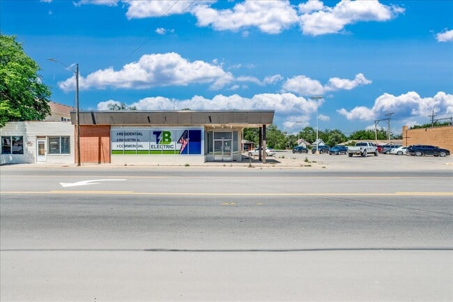
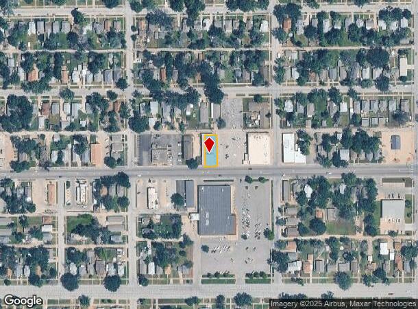

This Property Is For Sale
NEARBY LISTINGS FOR SALE OR LEASE
Property Detail
722 E 4Th Ave
Hutchinson, KS
Lees 2Nd
133-07-0-30-27-012.00
LEES 2ND, S07, T23, R05W, BLOCK 1, E 1/2 LOT 12 ALL LOT 13 AND W 13.5 FT LOT 14 BLK 1
Warehouse
Reno
X
Kansas
20155C0291G
12
2024
0.16 AC
2024
Kansas Area
000700
Other Market Areas
7,130 SF
DEMOGRAPHICS near 722 E 4Th Ave
1 mile
3 mile
5 mile
2024 Total Population
10,503
38,931
44,392
2029 Population
10,666
38,922
44,327
Pop Growth 2024-2029
+ 1.55%
(0.02%)
(0.15%)
Average Age
38
41
42
2024 Total Households
4,471
16,766
18,846
HH Growth 2024-2029
+ 1.66%
(0.08%)
(0.19%)
Median Household Inc
$47,823
$55,177
$57,698
Avg Household Size
2.20
2.20
2.20
2024 Avg HH Vehicles
2.00
2.00
2.00
Median Home Value
$63,748
$120,655
$132,548
Median Year Built
1949
1958
1960
Nearby Places
Map Layers
Map Styles
 Street
 Aerial
Transit
 Traffic
 Biking
Places
Listings with unknown addresses are not visible on the map
- Restaurants
- Banks
- Shops
- Fitness
- Groceries
PUBLIC TRANSPORTATION
COMMUTER RAIL
Drive
Walk
Distance
3 min
18 min
0.9 mi
AIRPORT
Wichita Dwight D Eisenhower Ntl
Drive
Walk
Distance
Wichita Dwight D Eisenhower Ntl
63 min
47.0 mi
Nearby Properties
Address
Land Use
TOTAL SIZE
Lot Size
Zoning
Address
Land Use
TOTAL SIZE
Lot Size
Zoning
19,260 SF
11 AC
P
Address
Land Use
TOTAL SIZE
Lot Size
Zoning
94,825 SF
10 AC
Address
Land Use
TOTAL SIZE
Lot Size
Zoning
89,458 SF
1.88 AC
P
Address
Land Use
TOTAL SIZE
Lot Size
Zoning
2,502 SF
44.42 AC
P
Address
Land Use
TOTAL SIZE
Lot Size
Zoning
3,120 SF
36.34 AC
PI
Address
Land Use
TOTAL SIZE
Lot Size
Zoning
2,400 SF
18 AC
Address
Land Use
TOTAL SIZE
Lot Size
Zoning
20,582 SF
8.85 AC
R5
Address
Land Use
TOTAL SIZE
Lot Size
Zoning
1,728 SF
10.68 AC
P
Address
Land Use
TOTAL SIZE
Lot Size
Zoning
59.65 AC
P
Address
Land Use
TOTAL SIZE
Lot Size
Zoning
10,292 SF
10.36 AC
R5
Address
Land Use
TOTAL SIZE
Lot Size
Zoning
54,149 SF
9.27 AC
Address
Land Use
TOTAL SIZE
Lot Size
Zoning
42,659 SF
4.58 AC
P
Address
Land Use
TOTAL SIZE
Lot Size
Zoning
579 SF
629.53 AC
Address
Land Use
TOTAL SIZE
Lot Size
Zoning
12,896 SF
102.35 AC
I3
Address
Land Use
TOTAL SIZE
Lot Size
Zoning
121,446 SF
14.69 AC
PI
Address
Land Use
TOTAL SIZE
Lot Size
Zoning
143 SF
110.23 AC
P
Address
Land Use
TOTAL SIZE
Lot Size
Zoning
1,960 SF
15.96 AC
Address
Land Use
TOTAL SIZE
Lot Size
Zoning
4,000 SF
19.83 AC
C1
Address
Land Use
TOTAL SIZE
Lot Size
Zoning
64,700 SF
5.73 AC
C4
Address
Land Use
TOTAL SIZE
Lot Size
Zoning
29,431 SF
1.50 AC
C5
Address
Land Use
TOTAL SIZE
Lot Size
Zoning
1,748 SF
6.40 AC
Address
Land Use
TOTAL SIZE
Lot Size
Zoning
64,802 SF
14.07 AC
P
Address
Land Use
TOTAL SIZE
Lot Size
Zoning
36,000 SF
19.49 AC
Address
Land Use
TOTAL SIZE
Lot Size
Zoning
43,928 SF
4.99 AC
R5
Address
Land Use
TOTAL SIZE
Lot Size
Zoning
1,320 SF
5.94 AC
Address
Land Use
TOTAL SIZE
Lot Size
Zoning
7,200 SF
35.24 AC
Address
Land Use
TOTAL SIZE
Lot Size
Zoning
3,648 SF
15.60 AC
CR
Address
Land Use
TOTAL SIZE
Lot Size
Zoning
1,136 SF
4.68 AC
Address
Land Use
TOTAL SIZE
Lot Size
Zoning
101,932 SF
1.50 AC
P
Address
Land Use
TOTAL SIZE
Lot Size
Zoning
89,591 SF
3.31 AC
P
The World's #1 Commercial Real Estate Marketplace
Connect with us
© 2026 CoStar Group
The information above has been obtained from sources believed reliable. While we do not doubt its accuracy we have not verified it and make no guarantee, warranty or representation about it. It is your responsibility to independently confirm its accuracy and completeness. Any projections, opinions, assumptions, or estimates used are for example only and do not represent the current or future performance of the property. The value of this transaction to you depends on tax and other factors which should be evaluated by your tax, financial, and legal advisors. You and your advisors should conduct a careful, independent investigation of the property to determine to your satisfaction the suitability of the property for your needs.