Property Record
722 E Ridge Rd, Griffith, IN 46319
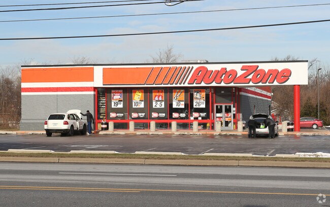

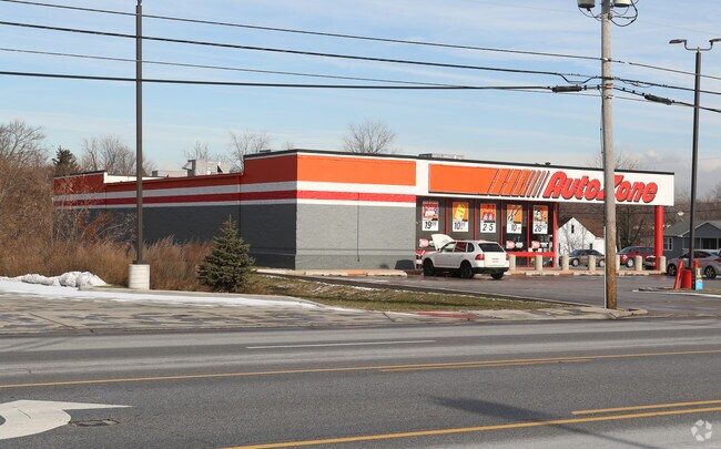
Property Detail
722 E Ridge Rd
45-07-26-202-007.000-006
WINDELLS JAY STREET 2ND SUB LOT 1
Storebuilding
Lake
R33
Indiana
B and X Area of moderate flood hazard, usually the area between the limits of the 100-year and 500-year floods.
1
2024
1.32 AC
2025
Indiana
041001
Chicago
7,570 SF
Chicago-Naperville-Elgin, IL-IN
NEARBY LISTINGS FOR SALE OR LEASE
DEMOGRAPHICS near 722 E Ridge Rd
1 mile
3 mile
5 mile
2025 Total Population
9,642
56,853
177,405
2030 Population
9,576
56,875
179,501
Pop Growth 2025-2030
(0.68%)
+ 0.04%
+ 1.18%
Average Age
39
40
41
2025 Total Households
4,065
23,145
71,164
HH Growth 2025-2030
(0.66%)
(0.03%)
+ 1.17%
Median Household Inc
$67,470
$64,762
$61,355
Avg Household Size
2.30
2.40
2.40
2025 Avg HH Vehicles
2.00
2.00
2.00
Median Home Value
$198,364
$199,905
$202,787
Median Year Built
1967
1963
1962
Nearby Places
Map Layers
Map Styles
 Street
 Aerial
Layers
 Traffic
 Biking
Places
Listings with unknown addresses are not visible on the map
- Restaurants
- Banks
- Shops
- Fitness
- Groceries
PUBLIC TRANSPORTATION
COMMUTER RAIL
Clark Road (Gary) Station (South Shore Line - Northern Indiana Commuter Transportation District (South Shore Line))
Drive
Walk
Distance
Clark Road (Gary) Station (South Shore Line - Northern Indiana Commuter Transportation District (South Shore Line))
11 min
5.3 mi
Drive
Walk
Distance
19 min
8.1 mi
AIRPORT
Chicago Midway International
Drive
Walk
Distance
Chicago Midway International
47 min
30.6 mi
Nearby Properties
Address
Land Use
TOTAL SIZE
Lot Size
Zoning
Address
Land Use
TOTAL SIZE
Lot Size
Zoning
233,023 SF
37.73 AC
Address
Land Use
TOTAL SIZE
Lot Size
Zoning
394,442 SF
16.83 AC
Address
Land Use
TOTAL SIZE
Lot Size
Zoning
80,444 SF
13.41 AC
R3
Address
Land Use
TOTAL SIZE
Lot Size
Zoning
77,091 SF
2.08 AC
Address
Land Use
TOTAL SIZE
Lot Size
Zoning
217,104 SF
10.45 AC
Address
Land Use
TOTAL SIZE
Lot Size
Zoning
79,169 SF
2.76 AC
Address
Land Use
TOTAL SIZE
Lot Size
Zoning
105,000 SF
2.90 AC
Address
Land Use
TOTAL SIZE
Lot Size
Zoning
34,116 SF
73.40 AC
Address
Land Use
TOTAL SIZE
Lot Size
Zoning
79,059 SF
7.07 AC
R3
Address
Land Use
TOTAL SIZE
Lot Size
Zoning
100,000 SF
7.29 AC
R3
Address
Land Use
TOTAL SIZE
Lot Size
Zoning
69,576 SF
2.55 AC
Address
Land Use
TOTAL SIZE
Lot Size
Zoning
53,096 SF
8.64 AC
R3
Address
Land Use
TOTAL SIZE
Lot Size
Zoning
60,234 SF
9.01 AC
Address
Land Use
TOTAL SIZE
Lot Size
Zoning
33,920 SF
83.34 AC
Address
Land Use
TOTAL SIZE
Lot Size
Zoning
55,656 SF
1.99 AC
R3
Address
Land Use
TOTAL SIZE
Lot Size
Zoning
74,229 SF
10.04 AC
Address
Land Use
TOTAL SIZE
Lot Size
Zoning
61,425 SF
3.29 AC
Address
Land Use
TOTAL SIZE
Lot Size
Zoning
46,398 SF
9.07 AC
Address
Land Use
TOTAL SIZE
Lot Size
Zoning
44,960 SF
4.80 AC
Address
Land Use
TOTAL SIZE
Lot Size
Zoning
111,363 SF
9.60 AC
Address
Land Use
TOTAL SIZE
Lot Size
Zoning
47,260 SF
1.61 AC
R3
Address
Land Use
TOTAL SIZE
Lot Size
Zoning
108,072 SF
5.76 AC
Address
Land Use
TOTAL SIZE
Lot Size
Zoning
39,036 SF
2.34 AC
Address
Land Use
TOTAL SIZE
Lot Size
Zoning
247,640 SF
22.88 AC
Address
Land Use
TOTAL SIZE
Lot Size
Zoning
42,886 SF
1.60 AC
R3
Address
Land Use
TOTAL SIZE
Lot Size
Zoning
123,848 SF
10.85 AC
Address
Land Use
TOTAL SIZE
Lot Size
Zoning
38,088 SF
2.60 AC
Address
Land Use
TOTAL SIZE
Lot Size
Zoning
83,120 SF
6 AC
Address
Land Use
TOTAL SIZE
Lot Size
Zoning
76,282 SF
2.55 AC
Address
Land Use
TOTAL SIZE
Lot Size
Zoning
24,964 SF
3.72 AC
The World's #1 Commercial Real Estate Marketplace
Connect with us
© 2026 CoStar Group
The information above has been obtained from sources believed reliable. While we do not doubt its accuracy we have not verified it and make no guarantee, warranty or representation about it. It is your responsibility to independently confirm its accuracy and completeness. Any projections, opinions, assumptions, or estimates used are for example only and do not represent the current or future performance of the property. The value of this transaction to you depends on tax and other factors which should be evaluated by your tax, financial, and legal advisors. You and your advisors should conduct a careful, independent investigation of the property to determine to your satisfaction the suitability of the property for your needs.