Property Record
722 E Union St, Morganton, NC 28655
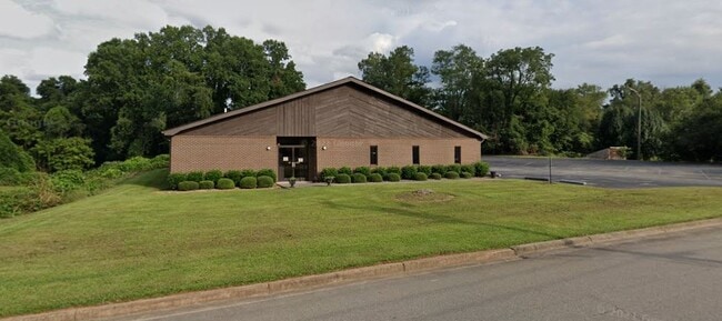

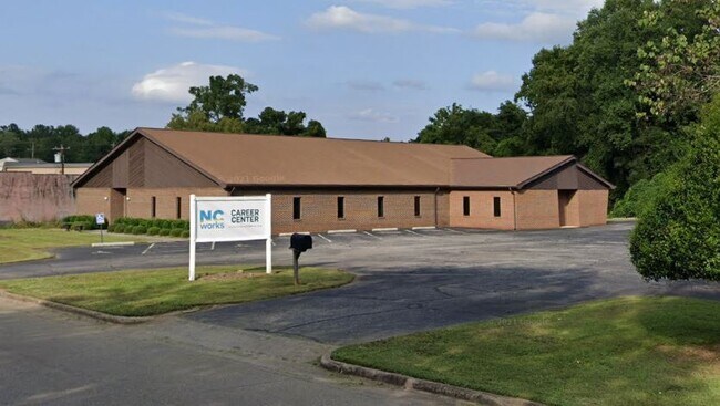

Property Detail
722 E Union St
6606
722 E UNION ST MORGANTON, NC 28655
Realpropertynec
BURKE
HIGH INTEN
North Carolina
B and X Area of moderate flood hazard, usually the area between the limits of the 100-year and 500-year floods.
2.23 AC
2025
Burke County
2025
Charlotte
021400
Hickory-Lenoir-Morganton, NC
6,773 SF
NEARBY LISTINGS FOR SALE OR LEASE
DEMOGRAPHICS near 722 E Union St
1 mile
3 mile
5 mile
2024 Total Population
5,773
19,458
34,322
2029 Population
5,812
19,653
34,590
Pop Growth 2024-2029
+ 0.68%
+ 1.00%
+ 0.78%
Average Age
41
43
44
2024 Total Households
2,307
7,776
13,688
HH Growth 2024-2029
+ 0.69%
+ 1.07%
+ 0.83%
Median Household Inc
$48,820
$48,370
$50,445
Avg Household Size
2.40
2.30
2.30
2024 Avg HH Vehicles
2.00
2.00
2.00
Median Home Value
$169,289
$181,603
$177,812
Median Year Built
1962
1972
1975
Nearby Places
Map Layers
Map Styles
 Street
 Aerial
Transit
 Traffic
 Biking
Places
Listings with unknown addresses are not visible on the map
- Restaurants
- Banks
- Shops
- Fitness
- Groceries
SALE & LEASE HISTORY
LISTING DATE
SALE/LEASE

Jan 10, 2025
For Sale
Nearby Properties
Address
Land Use
TOTAL SIZE
Lot Size
Zoning
Address
Land Use
TOTAL SIZE
Lot Size
Zoning
STATE INST
Address
Land Use
TOTAL SIZE
Lot Size
Zoning
80,043 SF
72.72 AC
HIGH INTEN
Address
Land Use
TOTAL SIZE
Lot Size
Zoning
89,004 SF
STATE INST
Address
Land Use
TOTAL SIZE
Lot Size
Zoning
32,074 SF
HIGH INTEN
Address
Land Use
TOTAL SIZE
Lot Size
Zoning
87,530 SF
HIGH INTEN
Address
Land Use
TOTAL SIZE
Lot Size
Zoning
6,912 SF
24.27 AC
HIGH INTEN
Address
Land Use
TOTAL SIZE
Lot Size
Zoning
146,058 SF
52.85 AC
MEDIUM INT
Address
Land Use
TOTAL SIZE
Lot Size
Zoning
MEDIUM INT
Address
Land Use
TOTAL SIZE
Lot Size
Zoning
2,176 SF
23.80 AC
RESIDENTIA
Address
Land Use
TOTAL SIZE
Lot Size
Zoning
HIGH INTEN
Address
Land Use
TOTAL SIZE
Lot Size
Zoning
LOW INTENS
Address
Land Use
TOTAL SIZE
Lot Size
Zoning
23,970 SF
33.98 AC
CONDITIONA
Address
Land Use
TOTAL SIZE
Lot Size
Zoning
MEDIUM INT
Address
Land Use
TOTAL SIZE
Lot Size
Zoning
73,530 SF
Address
Land Use
TOTAL SIZE
Lot Size
Zoning
185,929 SF
32.01 AC
CONDITIONA
Address
Land Use
TOTAL SIZE
Lot Size
Zoning
2,400 SF
26.53 AC
MEDIUM INT
Address
Land Use
TOTAL SIZE
Lot Size
Zoning
6,052 SF
13.04 AC
MEDIUM INT
Address
Land Use
TOTAL SIZE
Lot Size
Zoning
37,366 SF
22.36 AC
HIGH INTEN
Address
Land Use
TOTAL SIZE
Lot Size
Zoning
250,292 SF
53.11 AC
EXCLUSIVE
Address
Land Use
TOTAL SIZE
Lot Size
Zoning
2,160 SF
12.81 AC
MEDIUM INT
Address
Land Use
TOTAL SIZE
Lot Size
Zoning
6,402 SF
14.14 AC
MEDIUM INT
Address
Land Use
TOTAL SIZE
Lot Size
Zoning
52,977 SF
1.90 AC
MEDIUM INT
Address
Land Use
TOTAL SIZE
Lot Size
Zoning
135,387 SF
9.95 AC
HIGH INTEN
Address
Land Use
TOTAL SIZE
Lot Size
Zoning
32,698 SF
23 AC
MEDIUM INT
Address
Land Use
TOTAL SIZE
Lot Size
Zoning
25,986 SF
16.78 AC
HIGH INTEN
Address
Land Use
TOTAL SIZE
Lot Size
Zoning
HIGH INTEN
Address
Land Use
TOTAL SIZE
Lot Size
Zoning
58,998 SF
LOW INTENS
Address
Land Use
TOTAL SIZE
Lot Size
Zoning
71,060 SF
3.10 AC
HIGH INTEN
Address
Land Use
TOTAL SIZE
Lot Size
Zoning
40,056 SF
13.80 AC
CONDITIONA
Address
Land Use
TOTAL SIZE
Lot Size
Zoning
65,175 SF
13.48 AC
CONDITIONA
The World's #1 Commercial Real Estate Marketplace
Connect with us
© 2026 CoStar Group
The information above has been obtained from sources believed reliable. While we do not doubt its accuracy we have not verified it and make no guarantee, warranty or representation about it. It is your responsibility to independently confirm its accuracy and completeness. Any projections, opinions, assumptions, or estimates used are for example only and do not represent the current or future performance of the property. The value of this transaction to you depends on tax and other factors which should be evaluated by your tax, financial, and legal advisors. You and your advisors should conduct a careful, independent investigation of the property to determine to your satisfaction the suitability of the property for your needs.