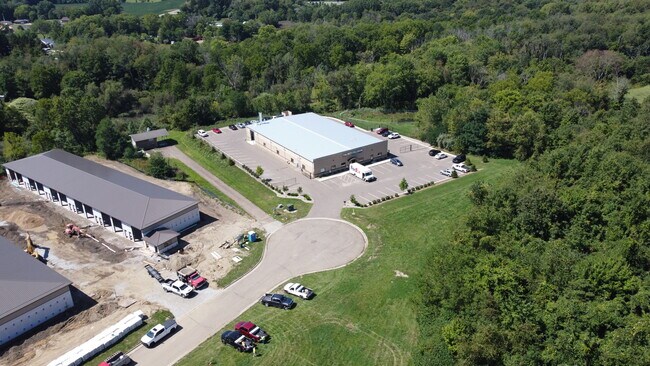
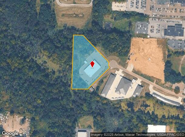
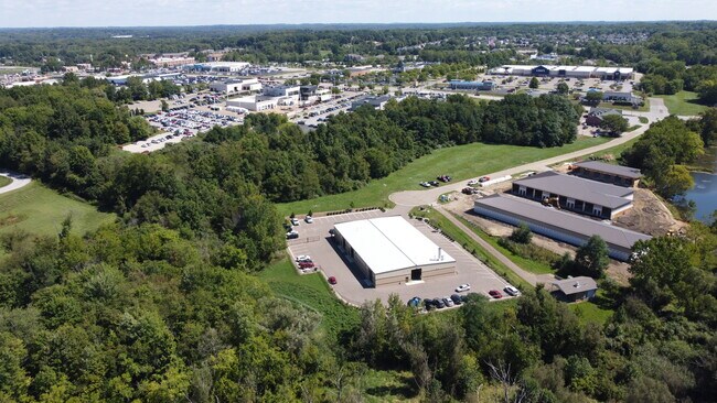
Property Record
722 Liberty Green Dr, Akron, OH 44312
NEARBY LISTINGS FOR SALE OR LEASE
Property Detail
722 Liberty Green Dr
Akron, OH
Liberty Green Subdivision Re-Plat No. 2
28-16520
LIBERTY GREEN SUBDIVISION RE-PLAT NO. 2 LOT 3-R ALL RN TIF PCL 2816801
Commercialnec
Summit
X
Ohio
39133C0325D
3-r
2023
3.03 AC
2025
Akron
531502
Cleveland
13,050 SF
DEMOGRAPHICS near 722 Liberty Green Dr
1 Mile
3 Mile
5 Mile
2024 Total Population
4,067
29,022
89,716
2029 Population
4,017
28,711
88,667
Pop Growth 2024-2029
(1.23%)
(1.07%)
(1.17%)
Average Age
42
44
42
2024 Total Households
1,648
12,484
38,124
HH Growth 2024-2029
(1.27%)
(1.08%)
(1.18%)
Median Household Inc
$86,755
$77,789
$64,676
Avg Household Size
2.40
2.30
2.30
2024 Avg HH Vehicles
2.00
2.00
2.00
Median Home Value
$264,657
$219,335
$171,471
Median Year Built
1993
1976
1965
Nearby Places
Map Layers
Map Styles
 Street
 Aerial
- Restaurants
- Banks
- Shops
- Fitness
- Groceries
PUBLIC TRANSPORTATION
COMMUTER RAIL
Akron Northside (National Park Scenic Railway - Cuyahoga Valley Scenic Railroad)
DRIVE
WALK
Distance
Akron Northside (National Park Scenic Railway - Cuyahoga Valley Scenic Railroad)
14 min
8.9 mi
AIRPORT
Akron-Canton Regional
DRIVE
WALK
Distance
Akron-Canton Regional
11 min
7.4 mi
Freight Ports
Port of Toledo
DRIVE
WALK
Distance
Port of Toledo
169 min
143.2 mi
SALE & LEASE HISTORY
LISTING DATE
SALE/LEASE

Sep 01, 2022
For Sale
Nearby Properties
Address
Land Use
TOTAL SIZE
Lot Size
Zoning
Address
Land Use
TOTAL SIZE
Lot Size
Zoning
Address
Land Use
TOTAL SIZE
Lot Size
Zoning
242,719 SF
50.20 AC
Address
Land Use
TOTAL SIZE
Lot Size
Zoning
1,049.17 AC
Address
Land Use
TOTAL SIZE
Lot Size
Zoning
57,369 SF
93.97 AC
Address
Land Use
TOTAL SIZE
Lot Size
Zoning
Address
Land Use
TOTAL SIZE
Lot Size
Zoning
Address
Land Use
TOTAL SIZE
Lot Size
Zoning
227,634 SF
21.46 AC
Address
Land Use
TOTAL SIZE
Lot Size
Zoning
Address
Land Use
TOTAL SIZE
Lot Size
Zoning
116,456 SF
76.66 AC
Address
Land Use
TOTAL SIZE
Lot Size
Zoning
209,516 SF
46.70 AC
Address
Land Use
TOTAL SIZE
Lot Size
Zoning
63,913 SF
10.34 AC
Address
Land Use
TOTAL SIZE
Lot Size
Zoning
133,899 SF
45.88 AC
Address
Land Use
TOTAL SIZE
Lot Size
Zoning
Address
Land Use
TOTAL SIZE
Lot Size
Zoning
128,295 SF
30.74 AC
Address
Land Use
TOTAL SIZE
Lot Size
Zoning
Address
Land Use
TOTAL SIZE
Lot Size
Zoning
22,589 SF
31.65 AC
Address
Land Use
TOTAL SIZE
Lot Size
Zoning
42,750 SF
24.99 AC
Address
Land Use
TOTAL SIZE
Lot Size
Zoning
22,977 SF
263.47 AC
Address
Land Use
TOTAL SIZE
Lot Size
Zoning
72,614 SF
14.91 AC
Address
Land Use
TOTAL SIZE
Lot Size
Zoning
Address
Land Use
TOTAL SIZE
Lot Size
Zoning
Address
Land Use
TOTAL SIZE
Lot Size
Zoning
Address
Land Use
TOTAL SIZE
Lot Size
Zoning
147,708 SF
4.76 AC
Address
Land Use
TOTAL SIZE
Lot Size
Zoning
34,972 SF
5.24 AC
Address
Land Use
TOTAL SIZE
Lot Size
Zoning
2.08 AC
Address
Land Use
TOTAL SIZE
Lot Size
Zoning
78,302 SF
19.73 AC
Address
Land Use
TOTAL SIZE
Lot Size
Zoning
Address
Land Use
TOTAL SIZE
Lot Size
Zoning
16,604 SF
248.86 AC
Address
Land Use
TOTAL SIZE
Lot Size
Zoning
57,782 SF
10.13 AC
Address
Land Use
TOTAL SIZE
Lot Size
Zoning
69,372 SF
7.86 AC
The World's #1 Commercial Real Estate Marketplace
Connect with us
© 2025 CoStar Group
The information above has been obtained from sources believed reliable. While we do not doubt its accuracy we have not verified it and make no guarantee, warranty or representation about it. It is your responsibility to independently confirm its accuracy and completeness. Any projections, opinions, assumptions, or estimates used are for example only and do not represent the current or future performance of the property. The value of this transaction to you depends on tax and other factors which should be evaluated by your tax, financial, and legal advisors. You and your advisors should conduct a careful, independent investigation of the property to determine to your satisfaction the suitability of the property for your needs.