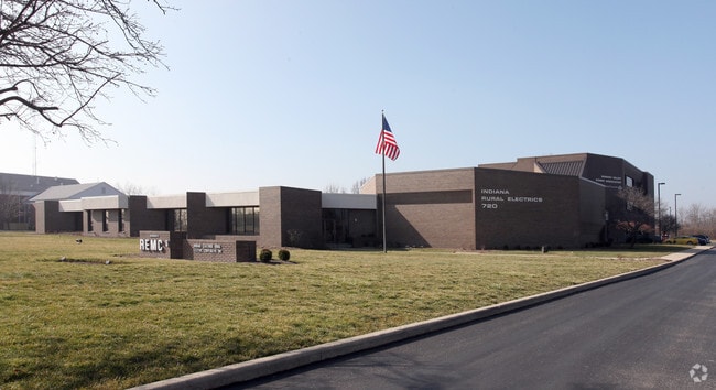
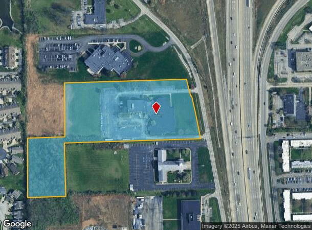
Property Record
722 N High School Rd, Indianapolis, IN 46214
This Property Is For Sale
NEARBY LISTINGS FOR SALE OR LEASE
Property Detail
722 N High School Rd
Indianapolis-Carmel-Anderson, IN
PT NE1/4 S2 T15 R2 BEG 1341 W & 1775.7 S OF NE COR P.O.B. E222.65 N315 E804.05 NW358.38 W724.81 S317.35 W222.65 S350 TO BEG 7.924 AC
49-12-02-125-007.000-982
Marion
Officebuilding
Indiana
2023
3
2024
7.92 AC
341902
Speedway
24,466 SF
Indianapolis
DEMOGRAPHICS near 722 N High School Rd
1 Mile
3 Mile
5 Mile
2024 Total Population
13,623
87,662
214,231
2029 Population
13,455
86,203
215,025
Pop Growth 2024-2029
(1.23%)
(1.66%)
+ 0.37%
Average Age
36
36
36
2024 Total Households
5,646
34,746
82,929
HH Growth 2024-2029
(1.36%)
(1.73%)
+ 0.32%
Median Household Inc
$45,989
$50,294
$52,732
Avg Household Size
2.40
2.40
2.50
2024 Avg HH Vehicles
1.00
2.00
2.00
Median Home Value
$159,339
$146,971
$144,693
Median Year Built
1971
1971
1974
Nearby Places
Map Layers
Map Styles
 Street
 Aerial
- Restaurants
- Banks
- Shops
- Fitness
- Groceries
PUBLIC TRANSPORTATION
COMMUTER RAIL
DRIVE
WALK
Distance
14 min
7.2 mi
AIRPORT
Indianapolis International
DRIVE
WALK
Distance
Indianapolis International
22 min
10.0 mi
Nearby Properties
Address
Land Use
TOTAL SIZE
Lot Size
Zoning
Address
Land Use
TOTAL SIZE
Lot Size
Zoning
1,340,481 SF
63.99 AC
ZO01
Address
Land Use
TOTAL SIZE
Lot Size
Zoning
80,249 SF
71.96 AC
ZO01
Address
Land Use
TOTAL SIZE
Lot Size
Zoning
5,280 SF
97.87 AC
ZO01
Address
Land Use
TOTAL SIZE
Lot Size
Zoning
1,413,414 SF
115.43 AC
ZO01
Address
Land Use
TOTAL SIZE
Lot Size
Zoning
415,877 SF
55.83 AC
ZO01
Address
Land Use
TOTAL SIZE
Lot Size
Zoning
9,750 SF
43.46 AC
ZO01
Address
Land Use
TOTAL SIZE
Lot Size
Zoning
578,964 SF
35.50 AC
ZO01
Address
Land Use
TOTAL SIZE
Lot Size
Zoning
1,889,477 SF
89.82 AC
ZO01
Address
Land Use
TOTAL SIZE
Lot Size
Zoning
27,327 SF
15 AC
Address
Land Use
TOTAL SIZE
Lot Size
Zoning
19,314 SF
32.88 AC
ZO01
Address
Land Use
TOTAL SIZE
Lot Size
Zoning
3,878 SF
17.76 AC
Address
Land Use
TOTAL SIZE
Lot Size
Zoning
438,643 SF
43.63 AC
ZO01
Address
Land Use
TOTAL SIZE
Lot Size
Zoning
7,364 SF
9.20 AC
Address
Land Use
TOTAL SIZE
Lot Size
Zoning
3,618 SF
31.13 AC
ZO01
Address
Land Use
TOTAL SIZE
Lot Size
Zoning
30,545 SF
3.41 AC
ZO01
Address
Land Use
TOTAL SIZE
Lot Size
Zoning
3,706 SF
30.57 AC
ZO01
Address
Land Use
TOTAL SIZE
Lot Size
Zoning
1,868 SF
14.50 AC
ZO01
Address
Land Use
TOTAL SIZE
Lot Size
Zoning
28,400 SF
22.04 AC
ZO01
Address
Land Use
TOTAL SIZE
Lot Size
Zoning
73,528 SF
80 AC
ZO01
Address
Land Use
TOTAL SIZE
Lot Size
Zoning
2,000 SF
57.60 AC
ZO01
Address
Land Use
TOTAL SIZE
Lot Size
Zoning
1,700 SF
40.37 AC
ZO01
Address
Land Use
TOTAL SIZE
Lot Size
Zoning
5,616 SF
9.34 AC
Address
Land Use
TOTAL SIZE
Lot Size
Zoning
2,288 SF
21.42 AC
Address
Land Use
TOTAL SIZE
Lot Size
Zoning
3,802 SF
12.25 AC
Address
Land Use
TOTAL SIZE
Lot Size
Zoning
120,734 SF
21.48 AC
Address
Land Use
TOTAL SIZE
Lot Size
Zoning
641,389 SF
44.90 AC
Address
Land Use
TOTAL SIZE
Lot Size
Zoning
57,100 SF
18.13 AC
Address
Land Use
TOTAL SIZE
Lot Size
Zoning
65,306 SF
39.30 AC
Address
Land Use
TOTAL SIZE
Lot Size
Zoning
20,039 SF
28.04 AC
ZO01
Address
Land Use
TOTAL SIZE
Lot Size
Zoning
2,965 SF
29.82 AC
ZO01
The World's #1 Commercial Real Estate Marketplace
Connect with us
© 2025 CoStar Group
The information above has been obtained from sources believed reliable. While we do not doubt its accuracy we have not verified it and make no guarantee, warranty or representation about it. It is your responsibility to independently confirm its accuracy and completeness. Any projections, opinions, assumptions, or estimates used are for example only and do not represent the current or future performance of the property. The value of this transaction to you depends on tax and other factors which should be evaluated by your tax, financial, and legal advisors. You and your advisors should conduct a careful, independent investigation of the property to determine to your satisfaction the suitability of the property for your needs.