Property Record
722 N Marsalis Ave, Dallas, TX 75203
NEARBY LISTINGS FOR SALE OR LEASE
Property Detail
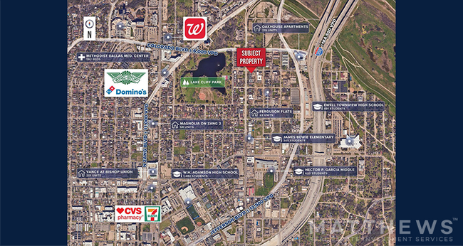
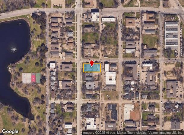
722 N Marsalis Ave
Dallas-Fort Worth-Arlington, TX
Original Oak Cliff
00000249328000000
ORIGINAL OAK CLIFF BLK 41/3022 LT 4 INT202100159221 DD05252021 CO-DC 3022 041 00400 2003022 041
Apartment
Dallas
X
Texas
48113C0340J
4
2024
0.39 AC
2025
Lake Cliff
002002
Dallas/Ft Worth
10,568 SF
DEMOGRAPHICS near 722 N Marsalis Ave
1 Mile
3 Mile
5 Mile
2024 Total Population
13,724
143,844
407,294
2029 Population
14,079
145,827
410,481
Pop Growth 2024-2029
+ 2.59%
+ 1.38%
+ 0.78%
Average Age
35
36
36
2024 Total Households
5,918
63,931
175,463
HH Growth 2024-2029
+ 2.38%
+ 1.70%
+ 0.98%
Median Household Inc
$46,476
$64,985
$59,597
Avg Household Size
2.20
2.10
2.20
2024 Avg HH Vehicles
2.00
2.00
2.00
Median Home Value
$391,434
$286,472
$254,959
Median Year Built
1981
1992
1986
Nearby Places
Map Layers
Map Styles
 Street
 Aerial
- Restaurants
- Banks
- Shops
- Fitness
- Groceries
PUBLIC TRANSPORTATION
TRANSIT/SUBWAY
Oakenwald Streetcar Station (DALLAS STREETCAR - Dallas Area Rapid Transit (DART))
DRIVE
WALK
Distance
Oakenwald Streetcar Station (DALLAS STREETCAR - Dallas Area Rapid Transit (DART))
1 min
7 min
0.4 mi
Greenbriar Streetcar Station (DALLAS STREETCAR - Dallas Area Rapid Transit (DART))
DRIVE
WALK
Distance
Greenbriar Streetcar Station (DALLAS STREETCAR - Dallas Area Rapid Transit (DART))
4 min
10 min
0.5 mi
Beckley Streetcar Station (DALLAS STREETCAR - Dallas Area Rapid Transit (DART))
DRIVE
WALK
Distance
Beckley Streetcar Station (DALLAS STREETCAR - Dallas Area Rapid Transit (DART))
1 min
10 min
0.6 mi
6Th Streetcar Station (DALLAS STREETCAR - Dallas Area Rapid Transit (DART))
DRIVE
WALK
Distance
6Th Streetcar Station (DALLAS STREETCAR - Dallas Area Rapid Transit (DART))
2 min
14 min
0.8 mi
Bishop Arts Station (DALLAS STREETCAR - Dallas Area Rapid Transit (DART))
DRIVE
WALK
Distance
Bishop Arts Station (DALLAS STREETCAR - Dallas Area Rapid Transit (DART))
2 min
19 min
1.0 mi
COMMUTER RAIL
Victory Station (DART LIGHT RAIL - GREEN LINE - Dallas Area Rapid Transit (DART), DART LIGHT RAIL - ORANGE LINE - Dallas Area Rapid Transit (DART), TRINITY RAILWAY - Dallas Area Rapid Transit (DART))
DRIVE
WALK
Distance
Victory Station (DART LIGHT RAIL - GREEN LINE - Dallas Area Rapid Transit (DART), DART LIGHT RAIL - ORANGE LINE - Dallas Area Rapid Transit (DART), TRINITY RAILWAY - Dallas Area Rapid Transit (DART))
5 min
3.0 mi
Medical/Market Ctr Station (TRINITY RAILWAY - Dallas Area Rapid Transit (DART))
DRIVE
WALK
Distance
Medical/Market Ctr Station (TRINITY RAILWAY - Dallas Area Rapid Transit (DART))
9 min
5.5 mi
AIRPORT
Dallas Love Field
DRIVE
WALK
Distance
Dallas Love Field
15 min
8.0 mi
Dallas-Fort Worth International
DRIVE
WALK
Distance
Dallas-Fort Worth International
28 min
22.1 mi
Freight Ports
Port of Shreveport
DRIVE
WALK
Distance
Port of Shreveport
213 min
198.1 mi
SALE & LEASE HISTORY
LISTING DATE
SALE/LEASE

Oct 03, 2024
For Sale
Mar 24, 2025
For Sale
Jul 30, 2024
For Sale
Jan 26, 2024
For Sale
Nearby Properties
Address
Land Use
TOTAL SIZE
Lot Size
Zoning
Address
Land Use
TOTAL SIZE
Lot Size
Zoning
3,713,071 SF
9.94 AC
Address
Land Use
TOTAL SIZE
Lot Size
Zoning
1,298,826 SF
33.16 AC
Z163
Address
Land Use
TOTAL SIZE
Lot Size
Zoning
815,000 SF
7.20 AC
Z239
Address
Land Use
TOTAL SIZE
Lot Size
Zoning
1,676,176 SF
2.18 AC
Z239
Address
Land Use
TOTAL SIZE
Lot Size
Zoning
906,730 SF
3.09 AC
Z239
Address
Land Use
TOTAL SIZE
Lot Size
Zoning
1,308,710 SF
8.42 AC
Z21
Address
Land Use
TOTAL SIZE
Lot Size
Zoning
731,849 SF
3.13 AC
Z239
Address
Land Use
TOTAL SIZE
Lot Size
Zoning
1,480,246 SF
1.86 AC
Z21
Address
Land Use
TOTAL SIZE
Lot Size
Zoning
1,291,660 SF
2.56 AC
Z248
Address
Land Use
TOTAL SIZE
Lot Size
Zoning
1,026,046 SF
2.89 AC
Z248
Address
Land Use
TOTAL SIZE
Lot Size
Zoning
864,909 SF
3.02 AC
Z248
Address
Land Use
TOTAL SIZE
Lot Size
Zoning
1,001,504 SF
3.37 AC
Z151
Address
Land Use
TOTAL SIZE
Lot Size
Zoning
1,424,070 SF
1.36 AC
Z21
Address
Land Use
TOTAL SIZE
Lot Size
Zoning
724,979 SF
1.05 AC
Z239
Address
Land Use
TOTAL SIZE
Lot Size
Zoning
893,159 SF
1.17 AC
Z21
Address
Land Use
TOTAL SIZE
Lot Size
Zoning
1,980,000 SF
2.57 AC
Z21
Address
Land Use
TOTAL SIZE
Lot Size
Zoning
857,292 SF
1.47 AC
Z239
Address
Land Use
TOTAL SIZE
Lot Size
Zoning
763,198 SF
3.01 AC
Z248
Address
Land Use
TOTAL SIZE
Lot Size
Zoning
638,046 SF
2.11 AC
Z239
Address
Land Use
TOTAL SIZE
Lot Size
Zoning
486,300 SF
1.55 AC
Z239
Address
Land Use
TOTAL SIZE
Lot Size
Zoning
906,627 SF
3.83 AC
Z239
Address
Land Use
TOTAL SIZE
Lot Size
Zoning
653,557 SF
0.68 AC
Z248
Address
Land Use
TOTAL SIZE
Lot Size
Zoning
676,930 SF
1.38 AC
Z248
Address
Land Use
TOTAL SIZE
Lot Size
Zoning
536,874 SF
1.03 AC
Z239
Address
Land Use
TOTAL SIZE
Lot Size
Zoning
784,725 SF
2.33 AC
Z239
Address
Land Use
TOTAL SIZE
Lot Size
Zoning
180,000 SF
4.66 AC
Z116
Address
Land Use
TOTAL SIZE
Lot Size
Zoning
818,188 SF
2.89 AC
Z239
Address
Land Use
TOTAL SIZE
Lot Size
Zoning
536,660 SF
2.02 AC
Z239
Address
Land Use
TOTAL SIZE
Lot Size
Zoning
1,848,034 SF
2.29 AC
Z21
Address
Land Use
TOTAL SIZE
Lot Size
Zoning
551,032 SF
3.13 AC
Z239
The World's #1 Commercial Real Estate Marketplace
Connect with us
© 2025 CoStar Group
The information above has been obtained from sources believed reliable. While we do not doubt its accuracy we have not verified it and make no guarantee, warranty or representation about it. It is your responsibility to independently confirm its accuracy and completeness. Any projections, opinions, assumptions, or estimates used are for example only and do not represent the current or future performance of the property. The value of this transaction to you depends on tax and other factors which should be evaluated by your tax, financial, and legal advisors. You and your advisors should conduct a careful, independent investigation of the property to determine to your satisfaction the suitability of the property for your needs.