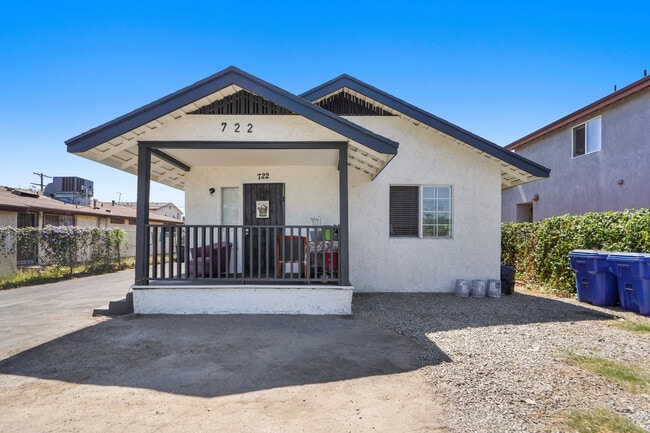
Property Record
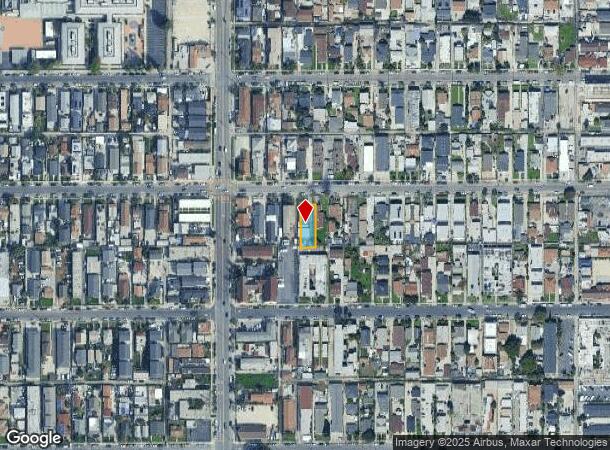
722 W 79Th St, Los Angeles, CA 90044
NEARBY LISTINGS FOR SALE OR LEASE
Property Detail
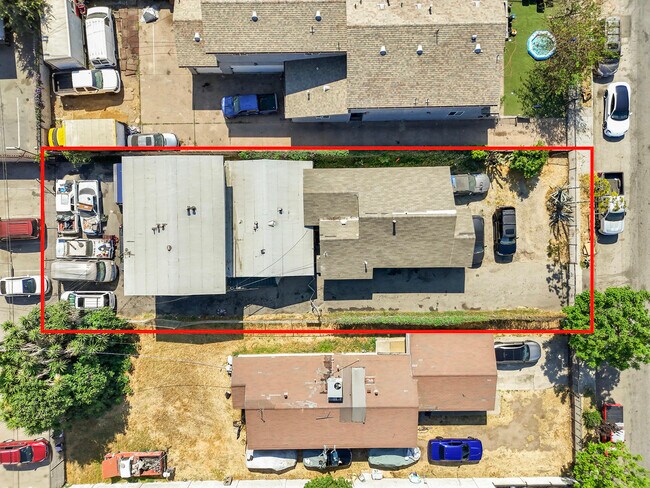
722 W 79Th St
Los Angeles-Long Beach-Glendale, CA
Figueroa Boulevard Tract
6032-027-020
FIGUEROA BOULEVARD TRACT EX OF ST LOT 355
Quadruplex
Los Angeles
X
California
06037C1785G
355
2024
0.16 AC
2025
South Central LA
238310
Los Angeles
3,226 SF
DEMOGRAPHICS near 722 W 79Th St
1 Mile
3 Mile
5 Mile
2024 Total Population
61,316
445,478
1,036,396
2029 Population
59,159
427,251
994,632
Pop Growth 2024-2029
(3.52%)
(4.09%)
(4.03%)
Average Age
35
36
36
2024 Total Households
16,697
120,818
296,604
HH Growth 2024-2029
(3.79%)
(4.34%)
(4.18%)
Median Household Inc
$43,284
$50,866
$53,581
Avg Household Size
3.50
3.50
3.30
2024 Avg HH Vehicles
2.00
2.00
2.00
Median Home Value
$536,604
$602,313
$647,539
Median Year Built
1950
1949
1953
Nearby Places
Map Layers
Map Styles
 Street
 Aerial
- Restaurants
- Banks
- Shops
- Fitness
- Groceries
PUBLIC TRANSPORTATION
COMMUTER RAIL
Los Angeles (Coast Starlight - Amtrak, Pacific Surfliner - Amtrak, Southwest Chief - Amtrak, Texas Eagle - Amtrak)
DRIVE
WALK
Distance
Los Angeles (Coast Starlight - Amtrak, Pacific Surfliner - Amtrak, Southwest Chief - Amtrak, Texas Eagle - Amtrak)
12 min
8.4 mi
Union Station (91 Line - Southern California Regional Rail Authority (Metrolink), Antelope Valley Line - Southern California Regional Rail Authority (Metrolink), Orange County Line - Southern California Regional Rail Authority (Metrolink), Riverside Line - Southern California Regional Rail Authority (Metrolink), San Bernardino Line - Southern California Regional Rail Authority (Metrolink), Ventura County Line - Southern California Regional Rail Authority (Metrolink))
DRIVE
WALK
Distance
Union Station (91 Line - Southern California Regional Rail Authority (Metrolink), Antelope Valley Line - Southern California Regional Rail Authority (Metrolink), Orange County Line - Southern California Regional Rail Authority (Metrolink), Riverside Line - Southern California Regional Rail Authority (Metrolink), San Bernardino Line - Southern California Regional Rail Authority (Metrolink), Ventura County Line - Southern California Regional Rail Authority (Metrolink))
15 min
8.6 mi
AIRPORT
Los Angeles International
DRIVE
WALK
Distance
Los Angeles International
16 min
8.7 mi
Long Beach (Daugherty Field)
DRIVE
WALK
Distance
Long Beach (Daugherty Field)
23 min
16.6 mi
Bob Hope
DRIVE
WALK
Distance
Bob Hope
32 min
23.6 mi
Freight Ports
Port of Long Beach
DRIVE
WALK
Distance
Port of Long Beach
26 min
18.5 mi
SALE & LEASE HISTORY
LISTING DATE
SALE/LEASE

Sep 13, 2022
For Sale
Jul 22, 2025
For Sale
Nearby Properties
Address
Land Use
TOTAL SIZE
Lot Size
Zoning
Address
Land Use
TOTAL SIZE
Lot Size
Zoning
2,531,696 SF
79.60 AC
INCR*
Address
Land Use
TOTAL SIZE
Lot Size
Zoning
57,488 SF
4.30 AC
LAPF
Address
Land Use
TOTAL SIZE
Lot Size
Zoning
127,484 SF
7.33 AC
LAM2
Address
Land Use
TOTAL SIZE
Lot Size
Zoning
81,735 SF
4.10 AC
LAR4
Address
Land Use
TOTAL SIZE
Lot Size
Zoning
103,656 SF
6.98 AC
LCM1
Address
Land Use
TOTAL SIZE
Lot Size
Zoning
402,118 SF
9.39 AC
LAC2
Address
Land Use
TOTAL SIZE
Lot Size
Zoning
111,213 SF
12.04 AC
LAR4
Address
Land Use
TOTAL SIZE
Lot Size
Zoning
173,222 SF
0.96 AC
LAR3
Address
Land Use
TOTAL SIZE
Lot Size
Zoning
188,030 SF
3.09 AC
LAR5
Address
Land Use
TOTAL SIZE
Lot Size
Zoning
135,060 SF
Address
Land Use
TOTAL SIZE
Lot Size
Zoning
51,006 SF
0.50 AC
LAC2
Address
Land Use
TOTAL SIZE
Lot Size
Zoning
102,260 SF
16.84 AC
LAR4
Address
Land Use
TOTAL SIZE
Lot Size
Zoning
80,606 SF
1.40 AC
INC2*
Address
Land Use
TOTAL SIZE
Lot Size
Zoning
73,697 SF
3.14 AC
LAC2
Address
Land Use
TOTAL SIZE
Lot Size
Zoning
90,887 SF
0.94 AC
LCR320U*
Address
Land Use
TOTAL SIZE
Lot Size
Zoning
131,879 SF
1.96 AC
LAC2
Address
Land Use
TOTAL SIZE
Lot Size
Zoning
189,808 SF
4.07 AC
LAM2
Address
Land Use
TOTAL SIZE
Lot Size
Zoning
333,054 SF
19.17 AC
INR1*
Address
Land Use
TOTAL SIZE
Lot Size
Zoning
108,496 SF
9.82 AC
LAM2
Address
Land Use
TOTAL SIZE
Lot Size
Zoning
113,733 SF
1.59 AC
LAM2
Address
Land Use
TOTAL SIZE
Lot Size
Zoning
142,152 SF
2.42 AC
LAC2
Address
Land Use
TOTAL SIZE
Lot Size
Zoning
38,567 SF
1.11 AC
LAR3
Address
Land Use
TOTAL SIZE
Lot Size
Zoning
40,065 SF
1.24 AC
LAC2
Address
Land Use
TOTAL SIZE
Lot Size
Zoning
2,036 SF
0.40 AC
LAC2
Address
Land Use
TOTAL SIZE
Lot Size
Zoning
89,036 SF
0.67 AC
LAC2
Address
Land Use
TOTAL SIZE
Lot Size
Zoning
107,421 SF
11.50 AC
INCR
Address
Land Use
TOTAL SIZE
Lot Size
Zoning
42,780 SF
0.53 AC
LAR3
Address
Land Use
TOTAL SIZE
Lot Size
Zoning
93,319 SF
1.70 AC
LAM2
Address
Land Use
TOTAL SIZE
Lot Size
Zoning
49,860 SF
1.08 AC
LAC2
Address
Land Use
TOTAL SIZE
Lot Size
Zoning
171,971 SF
5.21 AC
LCM2*
The World's #1 Commercial Real Estate Marketplace
Connect with us
© 2025 CoStar Group
The information above has been obtained from sources believed reliable. While we do not doubt its accuracy we have not verified it and make no guarantee, warranty or representation about it. It is your responsibility to independently confirm its accuracy and completeness. Any projections, opinions, assumptions, or estimates used are for example only and do not represent the current or future performance of the property. The value of this transaction to you depends on tax and other factors which should be evaluated by your tax, financial, and legal advisors. You and your advisors should conduct a careful, independent investigation of the property to determine to your satisfaction the suitability of the property for your needs.