Property Record
7220 Dexter Ann Arbor Rd, Dexter, MI 48130

Save to a Folder
{{folder.Name}}
{{folder.ListingIds.length}} Properties
{{folder.ListingIds.length}} Property
Create a New Folder
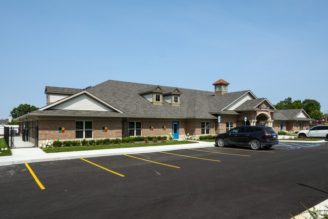
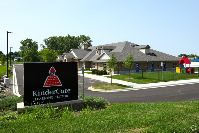
Property Detail
7220 Dexter Ann Arbor Rd
08-05-300-066
OWNER REQUEST COM AT S 1/4 COR SEC 5, TH N 89-50-33 W 678.87 FT, TH N 47-54-34 W 863.00 FT, TH N 42-05-25 E 60.00 FT TO A POB
Commercialnec
Washtenaw
PB
Michigan
B and X Area of moderate flood hazard, usually the area between the limits of the 100-year and 500-year floods.
2 AC
2025
Washtenaw W of 23
2026
Detroit
454002
Ann Arbor, MI
10,530 SF
NEARBY LISTINGS FOR SALE OR LEASE
DEMOGRAPHICS near 7220 Dexter Ann Arbor Rd
1 mile
3 mile
5 mile
2025 Total Population
3,916
12,001
27,331
2030 Population
3,951
12,075
27,540
Pop Growth 2025-2030
+ 0.89%
+ 0.62%
+ 0.76%
Average Age
42
42
42
2025 Total Households
1,609
4,655
10,364
HH Growth 2025-2030
+ 0.99%
+ 0.73%
+ 0.88%
Median Household Inc
$99,933
$111,085
$126,835
Avg Household Size
2.40
2.60
2.60
2025 Avg HH Vehicles
2.00
2.00
2.00
Median Home Value
$386,138
$423,163
$463,933
Median Year Built
1991
1990
1991
Nearby Places
Map Layers
Map Styles
 Street
 Aerial
Layers
 Traffic
 Biking
Places
Listings with unknown addresses are not visible on the map
- Restaurants
- Banks
- Shops
- Fitness
- Groceries
PUBLIC TRANSPORTATION
AIRPORT
Detroit Metro Wayne County
Drive
Walk
Distance
Detroit Metro Wayne County
35 min
34.2 mi
SALE & LEASE HISTORY
LISTING DATE
SALE/LEASE

Oct 24, 2016
For Lease
Nearby Properties
Address
Land Use
TOTAL SIZE
Lot Size
Zoning
Address
Land Use
TOTAL SIZE
Lot Size
Zoning
591,625 SF
80.39 AC
PUD
Address
Land Use
TOTAL SIZE
Lot Size
Zoning
1,760 SF
173.06 AC
MHP
Address
Land Use
TOTAL SIZE
Lot Size
Zoning
95,831 SF
26.98 AC
I-1
Address
Land Use
TOTAL SIZE
Lot Size
Zoning
147,400 SF
34.45 AC
SEVERAL
Address
Land Use
TOTAL SIZE
Lot Size
Zoning
132,280 SF
10.29 AC
I-1
Address
Land Use
TOTAL SIZE
Lot Size
Zoning
460,082 SF
42.24 AC
RD
Address
Land Use
TOTAL SIZE
Lot Size
Zoning
148,595 SF
13.28 AC
I-1
Address
Land Use
TOTAL SIZE
Lot Size
Zoning
443,838 SF
47.01 AC
I-1
Address
Land Use
TOTAL SIZE
Lot Size
Zoning
12.03 AC
R-3
Address
Land Use
TOTAL SIZE
Lot Size
Zoning
61,760 SF
18.06 AC
II
Address
Land Use
TOTAL SIZE
Lot Size
Zoning
84,460 SF
IFT PARCEL
Address
Land Use
TOTAL SIZE
Lot Size
Zoning
6.68 AC
R-3
Address
Land Use
TOTAL SIZE
Lot Size
Zoning
67,262 SF
9.05 AC
C-1
Address
Land Use
TOTAL SIZE
Lot Size
Zoning
2,913 SF
31.29 AC
C-3
Address
Land Use
TOTAL SIZE
Lot Size
Zoning
70,320 SF
2.79 AC
C-3
Address
Land Use
TOTAL SIZE
Lot Size
Zoning
54,150 SF
20.19 AC
I-1
Address
Land Use
TOTAL SIZE
Lot Size
Zoning
31,970 SF
8.34 AC
C-1
Address
Land Use
TOTAL SIZE
Lot Size
Zoning
52,990 SF
20.49 AC
I-1
Address
Land Use
TOTAL SIZE
Lot Size
Zoning
129,600 SF
10.27 AC
I-1
Address
Land Use
TOTAL SIZE
Lot Size
Zoning
12.63 AC
SEVERAL
Address
Land Use
TOTAL SIZE
Lot Size
Zoning
150,000 SF
18.24 AC
I-1
Address
Land Use
TOTAL SIZE
Lot Size
Zoning
49,707 SF
4.50 AC
C-1
Address
Land Use
TOTAL SIZE
Lot Size
Zoning
88,590 SF
9.80 AC
RD
Address
Land Use
TOTAL SIZE
Lot Size
Zoning
89,881 SF
12.82 AC
I-1
Address
Land Use
TOTAL SIZE
Lot Size
Zoning
61,382 SF
19.65 AC
I-1
Address
Land Use
TOTAL SIZE
Lot Size
Zoning
70,200 SF
8.06 AC
IRP
Address
Land Use
TOTAL SIZE
Lot Size
Zoning
68,000 SF
11.61 AC
RD
Address
Land Use
TOTAL SIZE
Lot Size
Zoning
Address
Land Use
TOTAL SIZE
Lot Size
Zoning
38,304 SF
5.76 AC
C-4
Address
Land Use
TOTAL SIZE
Lot Size
Zoning
4,788 SF
14.35 AC
SEVERAL
The World's #1 Commercial Real Estate Marketplace
Connect with us
© 2026 CoStar Group
The information above has been obtained from sources believed reliable. While we do not doubt its accuracy we have not verified it and make no guarantee, warranty or representation about it. It is your responsibility to independently confirm its accuracy and completeness. Any projections, opinions, assumptions, or estimates used are for example only and do not represent the current or future performance of the property. The value of this transaction to you depends on tax and other factors which should be evaluated by your tax, financial, and legal advisors. You and your advisors should conduct a careful, independent investigation of the property to determine to your satisfaction the suitability of the property for your needs.