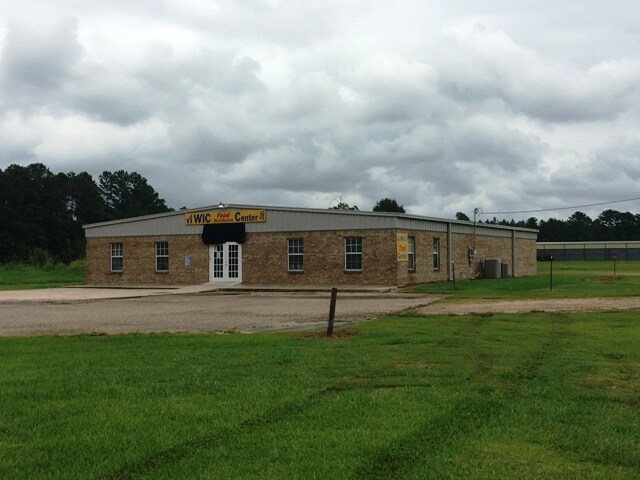
Property Record
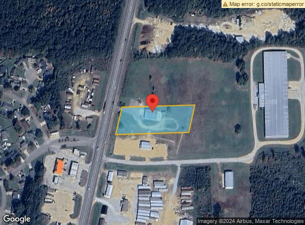
7220 Highway 45 N, Columbus, MS 39705
NEARBY LISTINGS FOR SALE OR LEASE
-
-
View all Columbus listings for sale on LoopNet.com
Property Detail
7220 Highway 45 N
33W23-00-25602
Sec9 T17s R18w Se4
Storebuilding
PT SE4 SE4 7220 HWY 45 N
X
Lowndes
28087C0160K
Mississippi
2025
1.80 AC
2025
Other Market Areas
000102
Columbus, MS
4,800 SF
DEMOGRAPHICS near 7220 Highway 45 N
1 Mile
3 Mile
5 Mile
2024 Total Population
868
6,181
14,487
2029 Population
853
6,131
14,217
Pop Growth 2024-2029
(1.73%)
(0.81%)
(1.86%)
Average Age
40
37
38
2024 Total Households
366
2,471
5,997
HH Growth 2024-2029
(1.64%)
(0.73%)
(1.87%)
Median Household Inc
$39,558
$61,831
$68,463
Avg Household Size
2.40
2.40
2.30
2024 Avg HH Vehicles
2.00
2.00
2.00
Median Home Value
$209,638
$193,594
$201,333
Median Year Built
1988
1987
1985
Nearby Places
Map Layers
Map Styles
 Street
 Aerial
- Restaurants
- Banks
- Shops
- Fitness
- Groceries
PUBLIC TRANSPORTATION
AIRPORT
Golden Triangle Regional
DRIVE
WALK
Distance
Golden Triangle Regional
30 min
19.0 mi
Freight Ports
Port of Mobile
DRIVE
WALK
Distance
Port of Mobile
267 min
228.5 mi
SALE & LEASE HISTORY
LISTING DATE
SALE/LEASE

Aug 22, 2017
For Sale
Nearby Properties
Address
Land Use
TOTAL SIZE
Lot Size
Zoning
Address
Land Use
TOTAL SIZE
Lot Size
Zoning
21,000 SF
22.70 AC
Address
Land Use
TOTAL SIZE
Lot Size
Zoning
8,000 SF
10 AC
Address
Land Use
TOTAL SIZE
Lot Size
Zoning
13,760 SF
6.10 AC
Address
Land Use
TOTAL SIZE
Lot Size
Zoning
4,950 SF
2 AC
Address
Land Use
TOTAL SIZE
Lot Size
Zoning
5,100 SF
14.20 AC
Address
Land Use
TOTAL SIZE
Lot Size
Zoning
2.35 AC
Address
Land Use
TOTAL SIZE
Lot Size
Zoning
2.07 AC
Address
Land Use
TOTAL SIZE
Lot Size
Zoning
4,800 SF
15 AC
Address
Land Use
TOTAL SIZE
Lot Size
Zoning
4,140 SF
2.28 AC
Address
Land Use
TOTAL SIZE
Lot Size
Zoning
10,396 SF
1.20 AC
Address
Land Use
TOTAL SIZE
Lot Size
Zoning
4,208 SF
0.53 AC
Address
Land Use
TOTAL SIZE
Lot Size
Zoning
1.01 AC
Address
Land Use
TOTAL SIZE
Lot Size
Zoning
5.40 AC
Address
Land Use
TOTAL SIZE
Lot Size
Zoning
3,160 SF
0.95 AC
Address
Land Use
TOTAL SIZE
Lot Size
Zoning
9,230 SF
1.70 AC
Address
Land Use
TOTAL SIZE
Lot Size
Zoning
5,103 SF
1.10 AC
Address
Land Use
TOTAL SIZE
Lot Size
Zoning
3,600 SF
1.85 AC
Address
Land Use
TOTAL SIZE
Lot Size
Zoning
4,413 SF
1 AC
Address
Land Use
TOTAL SIZE
Lot Size
Zoning
8,000 SF
2.20 AC
Address
Land Use
TOTAL SIZE
Lot Size
Zoning
13,864 SF
4.50 AC
Address
Land Use
TOTAL SIZE
Lot Size
Zoning
1,092 SF
1.20 AC
Address
Land Use
TOTAL SIZE
Lot Size
Zoning
8.30 AC
Address
Land Use
TOTAL SIZE
Lot Size
Zoning
2,805 SF
2.40 AC
Address
Land Use
TOTAL SIZE
Lot Size
Zoning
15,000 SF
2 AC
Address
Land Use
TOTAL SIZE
Lot Size
Zoning
4,200 SF
1.50 AC
Address
Land Use
TOTAL SIZE
Lot Size
Zoning
19,432 SF
0.60 AC
Address
Land Use
TOTAL SIZE
Lot Size
Zoning
2,584 SF
5.90 AC
Address
Land Use
TOTAL SIZE
Lot Size
Zoning
800 SF
13.30 AC
Address
Land Use
TOTAL SIZE
Lot Size
Zoning
800 SF
1.76 AC
The World's #1 Commercial Real Estate Marketplace
Connect with us
© 2025 CoStar Group
The information above has been obtained from sources believed reliable. While we do not doubt its accuracy we have not verified it and make no guarantee, warranty or representation about it. It is your responsibility to independently confirm its accuracy and completeness. Any projections, opinions, assumptions, or estimates used are for example only and do not represent the current or future performance of the property. The value of this transaction to you depends on tax and other factors which should be evaluated by your tax, financial, and legal advisors. You and your advisors should conduct a careful, independent investigation of the property to determine to your satisfaction the suitability of the property for your needs.