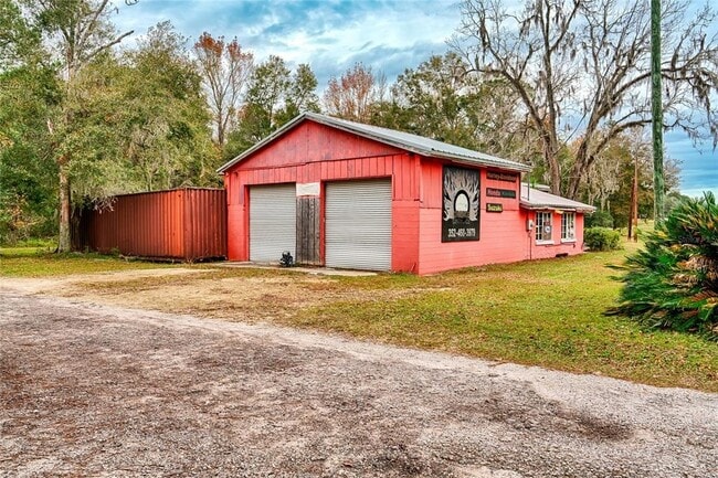
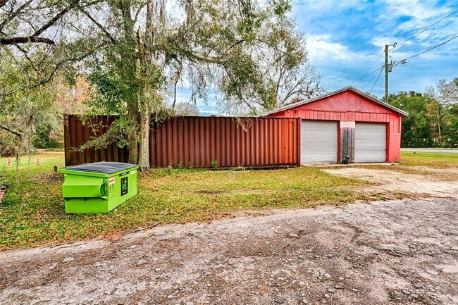
Property Record
7220 Ne Us Highway 301, Hawthorne, FL 32640

Current Lease Availabilities
Property Detail
7220 Ne Us Highway 301
18610-000-000
DAUGHERTY ADD ORANGE HGTS PB A-108 THAT PART OF LOTS 10 11 12 13 LYING S OF H/W 31 & SW OF US 301 ALSO LOTS 8 & 9 BLK 10 ORIG ORANGE HEIGHTS LYING SW OF US 301 ALSO THAT PART OF DAUGHERTY ST S OF H/W 31 & PT OF 1ST ST & 16 FT ALLEY SW OF US 301 & N O
Commercialnec
ALACHUA
BA
Florida
B and X Area of moderate flood hazard, usually the area between the limits of the 100-year and 500-year floods.
10
2025
1.06 AC
2025
Gainesville
001907
Other Market Areas
2,870 SF
Gainesville, FL
NEARBY LISTINGS FOR SALE OR LEASE
-
-
View all Hawthorne listings for lease on LoopNet.com
DEMOGRAPHICS near 7220 Ne Us Highway 301
1 mile
3 mile
5 mile
2025 Total Population
235
766
3,307
2030 Population
246
806
3,484
Pop Growth 2025-2030
+ 4.68%
+ 5.22%
+ 5.35%
Average Age
46
47
47
2025 Total Households
94
319
1,425
HH Growth 2025-2030
+ 5.32%
+ 5.96%
+ 5.82%
Median Household Inc
$55,357
$53,378
$55,248
Avg Household Size
2.50
2.40
2.30
2025 Avg HH Vehicles
2.00
2.00
2.00
Median Home Value
$223,333
$213,542
$214,096
Median Year Built
1983
1982
1982
Nearby Places
Map Layers
Map Styles
 Street
 Aerial
Transit
 Traffic
 Biking
Places
Listings with unknown addresses are not visible on the map
- Restaurants
- Banks
- Shops
- Fitness
- Groceries
PUBLIC TRANSPORTATION
AIRPORT
Gainesville Regional
Drive
Walk
Distance
Gainesville Regional
18 min
10.2 mi
Nearby Properties
Address
Land Use
TOTAL SIZE
Lot Size
Zoning
Address
Land Use
TOTAL SIZE
Lot Size
Zoning
12,800 SF
5.10 AC
MS
Address
Land Use
TOTAL SIZE
Lot Size
Zoning
12,209 SF
4.91 AC
A
Address
Land Use
TOTAL SIZE
Lot Size
Zoning
4,300 SF
1.89 AC
BH
Address
Land Use
TOTAL SIZE
Lot Size
Zoning
1,548 SF
92.06 AC
A
Address
Land Use
TOTAL SIZE
Lot Size
Zoning
3,751 SF
16.70 AC
A
Address
Land Use
TOTAL SIZE
Lot Size
Zoning
2,333 SF
18.97 AC
A
Address
Land Use
TOTAL SIZE
Lot Size
Zoning
4,078 SF
15 AC
A
Address
Land Use
TOTAL SIZE
Lot Size
Zoning
368.26 AC
A
Address
Land Use
TOTAL SIZE
Lot Size
Zoning
3,613 SF
20.08 AC
A
Address
Land Use
TOTAL SIZE
Lot Size
Zoning
4,320 SF
3.52 AC
A
Address
Land Use
TOTAL SIZE
Lot Size
Zoning
2,501 SF
2.01 AC
BR
Address
Land Use
TOTAL SIZE
Lot Size
Zoning
5,150 SF
2.50 AC
A
Address
Land Use
TOTAL SIZE
Lot Size
Zoning
2,176 SF
33.63 AC
A
Address
Land Use
TOTAL SIZE
Lot Size
Zoning
2,567 SF
5 AC
A
Address
Land Use
TOTAL SIZE
Lot Size
Zoning
492.76 AC
A
Address
Land Use
TOTAL SIZE
Lot Size
Zoning
5,858 SF
2.59 AC
A-RB
Address
Land Use
TOTAL SIZE
Lot Size
Zoning
3,347 SF
45.70 AC
A
Address
Land Use
TOTAL SIZE
Lot Size
Zoning
3,949 SF
29.50 AC
A
Address
Land Use
TOTAL SIZE
Lot Size
Zoning
3,672 SF
16.14 AC
A
Address
Land Use
TOTAL SIZE
Lot Size
Zoning
2,298 SF
18.84 AC
A
Address
Land Use
TOTAL SIZE
Lot Size
Zoning
3,813 SF
18.16 AC
A
Address
Land Use
TOTAL SIZE
Lot Size
Zoning
678 SF
102.69 AC
A
Address
Land Use
TOTAL SIZE
Lot Size
Zoning
4,682 SF
71.08 AC
A
Address
Land Use
TOTAL SIZE
Lot Size
Zoning
2,262 SF
24.08 AC
A
Address
Land Use
TOTAL SIZE
Lot Size
Zoning
20.75 AC
A
Address
Land Use
TOTAL SIZE
Lot Size
Zoning
2,592 SF
7.76 AC
A
Address
Land Use
TOTAL SIZE
Lot Size
Zoning
146.50 AC
A
Address
Land Use
TOTAL SIZE
Lot Size
Zoning
12.02 AC
A
Address
Land Use
TOTAL SIZE
Lot Size
Zoning
960 SF
19.70 AC
A
Address
Land Use
TOTAL SIZE
Lot Size
Zoning
5,160 SF
120 AC
A
The World's #1 Commercial Real Estate Marketplace
Connect with us
© 2026 CoStar Group
The information above has been obtained from sources believed reliable. While we do not doubt its accuracy we have not verified it and make no guarantee, warranty or representation about it. It is your responsibility to independently confirm its accuracy and completeness. Any projections, opinions, assumptions, or estimates used are for example only and do not represent the current or future performance of the property. The value of this transaction to you depends on tax and other factors which should be evaluated by your tax, financial, and legal advisors. You and your advisors should conduct a careful, independent investigation of the property to determine to your satisfaction the suitability of the property for your needs.