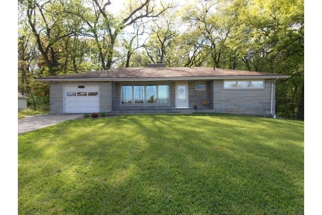
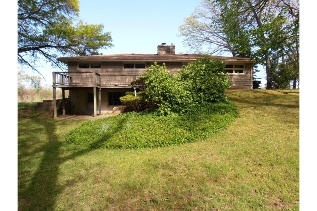
Property Record
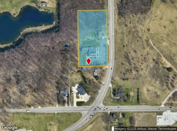
7221 N Fir Rd, Granger, IN 46530
NEARBY LISTINGS FOR SALE OR LEASE
Property Detail
7221 N Fir Rd
South Bend-Mishawaka, IN-MI
Rh Line Fir Rd Minor Sub
71-04-27-200-073.000-036
LOT 1 RH LINE FIR RD MINOR SUB 22/23 NP #54 1/15/2021 21/22 ANNEX ORD #5695 6/1/2020 FROM 06
Medicalbuilding
St Joseph
X
Indiana
18141C0207D
1
2023
4.14 AC
2024
Outlying St Joseph County
011505
South Bend/Mishawaka
13,661 SF
DEMOGRAPHICS near 7221 N Fir Rd
1 Mile
3 Mile
5 Mile
2024 Total Population
3,706
36,862
116,224
2029 Population
3,693
36,472
115,608
Pop Growth 2024-2029
(0.35%)
(1.06%)
(0.53%)
Average Age
40
41
39
2024 Total Households
1,555
15,080
45,774
HH Growth 2024-2029
(0.26%)
(1.06%)
(0.43%)
Median Household Inc
$72,386
$80,872
$67,275
Avg Household Size
2.30
2.40
2.30
2024 Avg HH Vehicles
2.00
2.00
2.00
Median Home Value
$236,214
$254,329
$192,073
Median Year Built
1993
1985
1975
Nearby Places
Map Layers
Map Styles
 Street
 Aerial
- Restaurants
- Banks
- Shops
- Fitness
- Groceries
PUBLIC TRANSPORTATION
COMMUTER RAIL
South Bend Amtrak Station (Capitol Limited - Amtrak, Lake Shore Limited - Amtrak)
DRIVE
WALK
Distance
South Bend Amtrak Station (Capitol Limited - Amtrak, Lake Shore Limited - Amtrak)
19 min
8.5 mi
South Bend Airport Station (South Shore Line - Northern Indiana Commuter Transportation District (South Shore Line))
DRIVE
WALK
Distance
South Bend Airport Station (South Shore Line - Northern Indiana Commuter Transportation District (South Shore Line))
20 min
9.8 mi
AIRPORT
South Bend International
DRIVE
WALK
Distance
South Bend International
30 min
12.3 mi
Freight Ports
Port Milwaukee
DRIVE
WALK
Distance
Port Milwaukee
221 min
184.6 mi
Nearby Properties
Address
Land Use
TOTAL SIZE
Lot Size
Zoning
Address
Land Use
TOTAL SIZE
Lot Size
Zoning
560,184 SF
0.01 AC
Address
Land Use
TOTAL SIZE
Lot Size
Zoning
529,154 SF
131 SF
Address
Land Use
TOTAL SIZE
Lot Size
Zoning
275,670 SF
44 SF
Address
Land Use
TOTAL SIZE
Lot Size
Zoning
262,392 SF
Address
Land Use
TOTAL SIZE
Lot Size
Zoning
599,502 SF
39.10 AC
Address
Land Use
TOTAL SIZE
Lot Size
Zoning
66,297 SF
131 SF
Address
Land Use
TOTAL SIZE
Lot Size
Zoning
239,419 SF
44 SF
Address
Land Use
TOTAL SIZE
Lot Size
Zoning
220,913 SF
29.14 AC
Address
Land Use
TOTAL SIZE
Lot Size
Zoning
18,028 SF
80.67 AC
Address
Land Use
TOTAL SIZE
Lot Size
Zoning
186,131 SF
87 SF
Address
Land Use
TOTAL SIZE
Lot Size
Zoning
331,913 SF
30 AC
Address
Land Use
TOTAL SIZE
Lot Size
Zoning
118,884 SF
44 SF
Address
Land Use
TOTAL SIZE
Lot Size
Zoning
138,405 SF
87 SF
Address
Land Use
TOTAL SIZE
Lot Size
Zoning
65,986 SF
174 SF
Address
Land Use
TOTAL SIZE
Lot Size
Zoning
192,770 SF
12.21 AC
Address
Land Use
TOTAL SIZE
Lot Size
Zoning
124,260 SF
44 SF
Address
Land Use
TOTAL SIZE
Lot Size
Zoning
2,368,321 SF
32.52 AC
Address
Land Use
TOTAL SIZE
Lot Size
Zoning
360,056 SF
19.59 AC
Address
Land Use
TOTAL SIZE
Lot Size
Zoning
92,030 SF
44 SF
Address
Land Use
TOTAL SIZE
Lot Size
Zoning
86,310 SF
87 SF
Address
Land Use
TOTAL SIZE
Lot Size
Zoning
147,760 SF
87 SF
Address
Land Use
TOTAL SIZE
Lot Size
Zoning
218,000 SF
24.57 AC
Address
Land Use
TOTAL SIZE
Lot Size
Zoning
83,367 SF
5.67 AC
Address
Land Use
TOTAL SIZE
Lot Size
Zoning
148,214 SF
87 SF
Address
Land Use
TOTAL SIZE
Lot Size
Zoning
100,347 SF
44 SF
Address
Land Use
TOTAL SIZE
Lot Size
Zoning
54,188 SF
10.32 AC
Address
Land Use
TOTAL SIZE
Lot Size
Zoning
172,995 SF
14.44 AC
Address
Land Use
TOTAL SIZE
Lot Size
Zoning
180,257 SF
20.94 AC
Address
Land Use
TOTAL SIZE
Lot Size
Zoning
54,226 SF
44 SF
Address
Land Use
TOTAL SIZE
Lot Size
Zoning
173,400 SF
10.73 AC
The World's #1 Commercial Real Estate Marketplace
Connect with us
© 2026 CoStar Group
The information above has been obtained from sources believed reliable. While we do not doubt its accuracy we have not verified it and make no guarantee, warranty or representation about it. It is your responsibility to independently confirm its accuracy and completeness. Any projections, opinions, assumptions, or estimates used are for example only and do not represent the current or future performance of the property. The value of this transaction to you depends on tax and other factors which should be evaluated by your tax, financial, and legal advisors. You and your advisors should conduct a careful, independent investigation of the property to determine to your satisfaction the suitability of the property for your needs.