Property Record
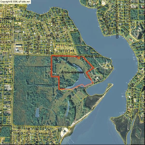
7222 Boat Race Rd, Panama City, FL 32404

NEARBY LISTINGS FOR SALE OR LEASE
Property Detail
7222 Boat Race Rd
Panama City-Panama City Beach, FL
Callaway Point Phase Ii
07378-000-000
20 4S 13W -2- 132D COM AT THE NW COR OF SEC TH E ALONG NORTH LINE 2532.74 TH S44 DEG E 53.63 TO THE SLY LINE OF BOATRACE RD TH W 28.06 TH S44 DEG E 598.44 SWLY 317 SELY 442.95 SWLY 343.65 NWLY 112.68 SWLY 439.35 SELY 703.04 SWLY 90 FOR POB TH NWLY 49
Commercialacreage
Bay
AE
Florida
12005C0364J
2
2024
10.41 AC
2025
Panama City
000806
Other Market Areas
DEMOGRAPHICS near 7222 Boat Race Rd
1 Mile
3 Mile
5 Mile
2024 Total Population
4,442
20,153
35,786
2029 Population
4,790
21,682
38,629
Pop Growth 2024-2029
+ 7.83%
+ 7.59%
+ 7.94%
Average Age
41
40
39
2024 Total Households
1,698
7,727
13,483
HH Growth 2024-2029
+ 8.36%
+ 8.20%
+ 8.40%
Median Household Inc
$59,649
$54,649
$52,152
Avg Household Size
2.60
2.60
2.60
2024 Avg HH Vehicles
2.00
2.00
2.00
Median Home Value
$202,800
$168,540
$171,541
Median Year Built
1986
1985
1983
Nearby Places
Map Layers
Map Styles
 Street
 Aerial
- Restaurants
- Banks
- Shops
- Fitness
- Groceries
PUBLIC TRANSPORTATION
AIRPORT
Northwest Florida Beaches International
DRIVE
WALK
Distance
Northwest Florida Beaches International
47 min
29.1 mi
Freight Ports
Port of Panama City
DRIVE
WALK
Distance
Port of Panama City
25 min
13.2 mi
Nearby Properties
Address
Land Use
TOTAL SIZE
Lot Size
Zoning
Address
Land Use
TOTAL SIZE
Lot Size
Zoning
650 AC
BC14
Address
Land Use
TOTAL SIZE
Lot Size
Zoning
20,942 SF
15.90 AC
Address
Land Use
TOTAL SIZE
Lot Size
Zoning
143,208 SF
5.26 AC
Address
Land Use
TOTAL SIZE
Lot Size
Zoning
181,571 SF
22.29 AC
CLWY04
Address
Land Use
TOTAL SIZE
Lot Size
Zoning
107,778 SF
10 AC
Address
Land Use
TOTAL SIZE
Lot Size
Zoning
39,628 SF
4.45 AC
CLWY04
Address
Land Use
TOTAL SIZE
Lot Size
Zoning
40,264 SF
2 AC
CLWY04
Address
Land Use
TOTAL SIZE
Lot Size
Zoning
42,456 SF
3.90 AC
CLWY04
Address
Land Use
TOTAL SIZE
Lot Size
Zoning
45,403 SF
2.65 AC
CLWY04
Address
Land Use
TOTAL SIZE
Lot Size
Zoning
48,576 SF
5.20 AC
CLWY23
Address
Land Use
TOTAL SIZE
Lot Size
Zoning
46,368 SF
2.30 AC
CLWY23
Address
Land Use
TOTAL SIZE
Lot Size
Zoning
38,784 SF
4.50 AC
CLWY23
Address
Land Use
TOTAL SIZE
Lot Size
Zoning
70,028 SF
6.64 AC
CLWY04
Address
Land Use
TOTAL SIZE
Lot Size
Zoning
Address
Land Use
TOTAL SIZE
Lot Size
Zoning
90,684 SF
15.59 AC
CLWY08
Address
Land Use
TOTAL SIZE
Lot Size
Zoning
21,088 SF
40 AC
CLWY12
Address
Land Use
TOTAL SIZE
Lot Size
Zoning
29,620 SF
8.64 AC
CLWY04
Address
Land Use
TOTAL SIZE
Lot Size
Zoning
52,727 SF
6.80 AC
Address
Land Use
TOTAL SIZE
Lot Size
Zoning
54,628 SF
3.43 AC
CLWY04
Address
Land Use
TOTAL SIZE
Lot Size
Zoning
8.68 AC
Address
Land Use
TOTAL SIZE
Lot Size
Zoning
22,660 SF
2.90 AC
Address
Land Use
TOTAL SIZE
Lot Size
Zoning
6,060 SF
7.22 AC
CLWY04
Address
Land Use
TOTAL SIZE
Lot Size
Zoning
4,872 SF
3.11 AC
BC04
Address
Land Use
TOTAL SIZE
Lot Size
Zoning
18,704 SF
2.51 AC
CLWY04
Address
Land Use
TOTAL SIZE
Lot Size
Zoning
26,844 SF
1.36 AC
CLWY04
Address
Land Use
TOTAL SIZE
Lot Size
Zoning
4,869 SF
11.01 AC
CLWY12
Address
Land Use
TOTAL SIZE
Lot Size
Zoning
20,000 SF
1.95 AC
CLWY04
Address
Land Use
TOTAL SIZE
Lot Size
Zoning
27,020 SF
4.90 AC
CLWY08
Address
Land Use
TOTAL SIZE
Lot Size
Zoning
64,068 SF
5.59 AC
Address
Land Use
TOTAL SIZE
Lot Size
Zoning
The World's #1 Commercial Real Estate Marketplace
Connect with us
© 2026 CoStar Group
The information above has been obtained from sources believed reliable. While we do not doubt its accuracy we have not verified it and make no guarantee, warranty or representation about it. It is your responsibility to independently confirm its accuracy and completeness. Any projections, opinions, assumptions, or estimates used are for example only and do not represent the current or future performance of the property. The value of this transaction to you depends on tax and other factors which should be evaluated by your tax, financial, and legal advisors. You and your advisors should conduct a careful, independent investigation of the property to determine to your satisfaction the suitability of the property for your needs.