Property Record
7225 Crain Hwy, La Plata, MD 20646


NEARBY LISTINGS FOR SALE OR LEASE
-
-
View all La Plata listings for sale on LoopNet.com
Property Detail
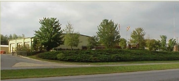
7225 Crain Hwy
Washington-Arlington-Alexandria, DC-VA-MD-WV
Town Of La Plata
01-035282
PAR 3 = 9.40 AC LA PLAT COMMERCE CENTER TOWN OF LA PLATA
Warehouse
Charles
X
Maryland
24017C0188C
3
2023
9.40 AC
2025
Charles County
851001
Washington, DC
8,800 SF
DEMOGRAPHICS near 7225 Crain Hwy
1 Mile
3 Mile
5 Mile
2024 Total Population
3,444
15,677
26,234
2029 Population
3,639
16,459
27,524
Pop Growth 2024-2029
+ 5.66%
+ 4.99%
+ 4.92%
Average Age
40
41
41
2024 Total Households
1,284
5,668
9,462
HH Growth 2024-2029
+ 5.76%
+ 5.05%
+ 4.92%
Median Household Inc
$98,546
$112,924
$113,097
Avg Household Size
2.60
2.70
2.70
2024 Avg HH Vehicles
2.00
2.00
2.00
Median Home Value
$357,392
$399,492
$407,415
Median Year Built
1997
1989
1992
Nearby Places
Map Layers
Map Styles
 Street
 Aerial
- Restaurants
- Banks
- Shops
- Fitness
- Groceries
PUBLIC TRANSPORTATION
AIRPORT
Ronald Reagan Washington Ntl
DRIVE
WALK
Distance
Ronald Reagan Washington Ntl
60 min
32.6 mi
Nearby Properties
Address
Land Use
TOTAL SIZE
Lot Size
Zoning
Address
Land Use
TOTAL SIZE
Lot Size
Zoning
315,662 SF
134.30 AC
PL
Address
Land Use
TOTAL SIZE
Lot Size
Zoning
150,480 SF
4.60 AC
CH
Address
Land Use
TOTAL SIZE
Lot Size
Zoning
6.54 AC
PL
Address
Land Use
TOTAL SIZE
Lot Size
Zoning
80,682 SF
11.35 AC
C-H
Address
Land Use
TOTAL SIZE
Lot Size
Zoning
98,995 SF
16.83 AC
NCX
Address
Land Use
TOTAL SIZE
Lot Size
Zoning
53,638 SF
3.76 AC
MUD-3
Address
Land Use
TOTAL SIZE
Lot Size
Zoning
129,001 SF
11.64 AC
C-H
Address
Land Use
TOTAL SIZE
Lot Size
Zoning
106,711 SF
92.18 AC
PL
Address
Land Use
TOTAL SIZE
Lot Size
Zoning
65,890 SF
6.70 AC
PL
Address
Land Use
TOTAL SIZE
Lot Size
Zoning
35,976 SF
3.97 AC
CH
Address
Land Use
TOTAL SIZE
Lot Size
Zoning
44,620 SF
9 AC
R-10
Address
Land Use
TOTAL SIZE
Lot Size
Zoning
70,913 SF
6.02 AC
CH
Address
Land Use
TOTAL SIZE
Lot Size
Zoning
75,375 SF
4.34 AC
C-B
Address
Land Use
TOTAL SIZE
Lot Size
Zoning
140,188 SF
15 AC
CH
Address
Land Use
TOTAL SIZE
Lot Size
Zoning
89,000 SF
2.13 AC
CB
Address
Land Use
TOTAL SIZE
Lot Size
Zoning
68,859 SF
3.75 AC
MUD-3
Address
Land Use
TOTAL SIZE
Lot Size
Zoning
31,194 SF
6.05 AC
RC
Address
Land Use
TOTAL SIZE
Lot Size
Zoning
3,696 SF
578.77 AC
MUD-3
Address
Land Use
TOTAL SIZE
Lot Size
Zoning
60,310 SF
2.99 AC
LI
Address
Land Use
TOTAL SIZE
Lot Size
Zoning
39,936 SF
6.24 AC
LI
Address
Land Use
TOTAL SIZE
Lot Size
Zoning
78,798 SF
5.64 AC
R3
Address
Land Use
TOTAL SIZE
Lot Size
Zoning
38,228 SF
21.77 AC
PL
Address
Land Use
TOTAL SIZE
Lot Size
Zoning
39,786 SF
1.53 AC
C-B
Address
Land Use
TOTAL SIZE
Lot Size
Zoning
49,790 SF
8.28 AC
C-H
Address
Land Use
TOTAL SIZE
Lot Size
Zoning
51,576 SF
2.67 AC
R10
Address
Land Use
TOTAL SIZE
Lot Size
Zoning
39,626 SF
4.07 AC
C-H
Address
Land Use
TOTAL SIZE
Lot Size
Zoning
60,244 SF
5.27 AC
MUD-2
Address
Land Use
TOTAL SIZE
Lot Size
Zoning
4,642 SF
3.90 AC
CC
Address
Land Use
TOTAL SIZE
Lot Size
Zoning
16,620 SF
2.15 AC
R-21
Address
Land Use
TOTAL SIZE
Lot Size
Zoning
37,500 SF
5.32 AC
CHLI
The World's #1 Commercial Real Estate Marketplace
Connect with us
© 2025 CoStar Group
The information above has been obtained from sources believed reliable. While we do not doubt its accuracy we have not verified it and make no guarantee, warranty or representation about it. It is your responsibility to independently confirm its accuracy and completeness. Any projections, opinions, assumptions, or estimates used are for example only and do not represent the current or future performance of the property. The value of this transaction to you depends on tax and other factors which should be evaluated by your tax, financial, and legal advisors. You and your advisors should conduct a careful, independent investigation of the property to determine to your satisfaction the suitability of the property for your needs.