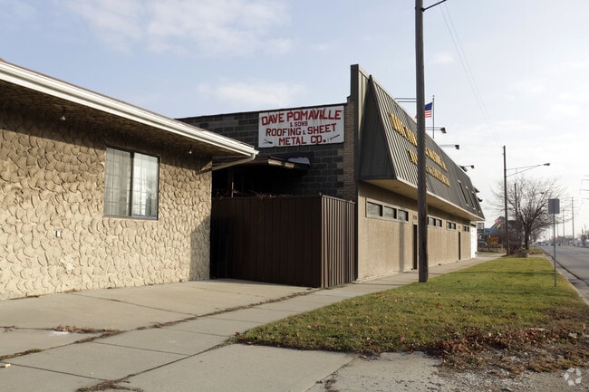
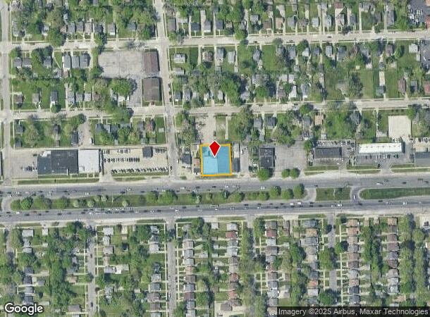
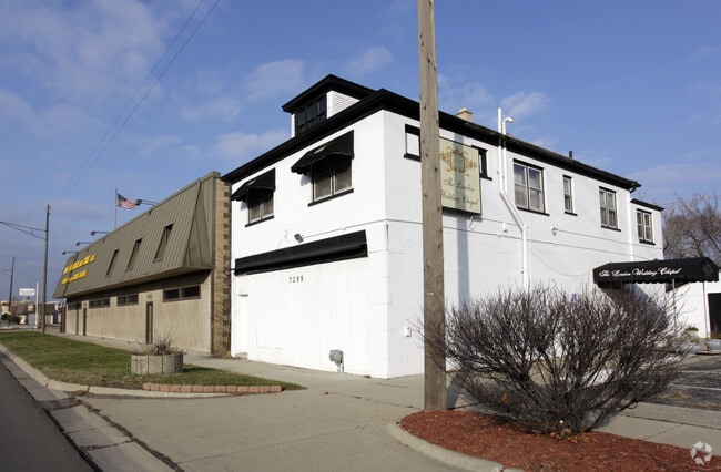
Property Record
7233 E 8 Mile Rd, Warren, MI 48091
NEARBY LISTINGS FOR SALE OR LEASE
Property Detail
7233 E 8 Mile Rd
Detroit-Warren-Dearborn, MI
S Gardens Subdivision
12-13-33-479-025
RIVARDS GARDENS SUB'N LOTS 210, 211 & 212 L.4 P.39
Lightindustrial
Macomb
X
Michigan
26163C0125E
210-212
2025
0.33 AC
2025
W of Van Dyke/Macomb
263800
Detroit
10,480 SF
DEMOGRAPHICS near 7233 E 8 Mile Rd
1 Mile
3 Mile
5 Mile
2024 Total Population
13,970
129,411
377,170
2029 Population
13,843
129,523
376,675
Pop Growth 2024-2029
(0.91%)
+ 0.09%
(0.13%)
Average Age
35
37
38
2024 Total Households
5,104
48,408
143,313
HH Growth 2024-2029
(1.10%)
+ 0.02%
(0.08%)
Median Household Inc
$37,582
$40,045
$43,048
Avg Household Size
2.60
2.60
2.50
2024 Avg HH Vehicles
1.00
1.00
1.00
Median Home Value
$56,575
$75,005
$96,858
Median Year Built
1952
1954
1955
Nearby Places
Map Layers
Map Styles
 Street
 Aerial
- Restaurants
- Banks
- Shops
- Fitness
- Groceries
PUBLIC TRANSPORTATION
COMMUTER RAIL
DRIVE
WALK
Distance
16 min
8.3 mi
DRIVE
WALK
Distance
17 min
9.8 mi
AIRPORT
Windsor International
DRIVE
WALK
Distance
Windsor International
41 min
21.7 mi
Detroit Metro Wayne County
DRIVE
WALK
Distance
Detroit Metro Wayne County
46 min
31.3 mi
Nearby Properties
Address
Land Use
TOTAL SIZE
Lot Size
Zoning
Address
Land Use
TOTAL SIZE
Lot Size
Zoning
419,600 SF
Address
Land Use
TOTAL SIZE
Lot Size
Zoning
3,327,621 SF
130.89 AC
M-4
Address
Land Use
TOTAL SIZE
Lot Size
Zoning
450,958 SF
Address
Land Use
TOTAL SIZE
Lot Size
Zoning
1,784,888 SF
58.32 AC
M-4
Address
Land Use
TOTAL SIZE
Lot Size
Zoning
455,425 SF
Address
Land Use
TOTAL SIZE
Lot Size
Zoning
182,866 SF
5.08 AC
PD
Address
Land Use
TOTAL SIZE
Lot Size
Zoning
401,671 SF
19.40 AC
MZ
Address
Land Use
TOTAL SIZE
Lot Size
Zoning
198,064 SF
11.11 AC
MZ
Address
Land Use
TOTAL SIZE
Lot Size
Zoning
1,261,658 SF
71.94 AC
M-2
Address
Land Use
TOTAL SIZE
Lot Size
Zoning
162,597 SF
17.94 AC
C-2
Address
Land Use
TOTAL SIZE
Lot Size
Zoning
Address
Land Use
TOTAL SIZE
Lot Size
Zoning
362,895 SF
14.85 AC
M-2
Address
Land Use
TOTAL SIZE
Lot Size
Zoning
259,959 SF
27.39 AC
MZ
Address
Land Use
TOTAL SIZE
Lot Size
Zoning
1,094,075 SF
58.76 AC
M-4
Address
Land Use
TOTAL SIZE
Lot Size
Zoning
303,615 SF
22.07 AC
MZ
Address
Land Use
TOTAL SIZE
Lot Size
Zoning
426,764 SF
38.46 AC
R-M
Address
Land Use
TOTAL SIZE
Lot Size
Zoning
197,670 SF
42.84 AC
M4
Address
Land Use
TOTAL SIZE
Lot Size
Zoning
166,064 SF
6.33 AC
M-3
Address
Land Use
TOTAL SIZE
Lot Size
Zoning
123,844 SF
1.81 AC
R2
Address
Land Use
TOTAL SIZE
Lot Size
Zoning
156,250 SF
8.79 AC
B4
Address
Land Use
TOTAL SIZE
Lot Size
Zoning
116,060 SF
6.95 AC
R2
Address
Land Use
TOTAL SIZE
Lot Size
Zoning
184,986 SF
13.49 AC
MZ
Address
Land Use
TOTAL SIZE
Lot Size
Zoning
410,359 SF
27.52 AC
M4
Address
Land Use
TOTAL SIZE
Lot Size
Zoning
125,055 SF
7.74 AC
MZ
Address
Land Use
TOTAL SIZE
Lot Size
Zoning
81,072 SF
5.67 AC
M-4
Address
Land Use
TOTAL SIZE
Lot Size
Zoning
63,949 SF
10.41 AC
R-1-C
Address
Land Use
TOTAL SIZE
Lot Size
Zoning
180,834 SF
17.97 AC
M-3
Address
Land Use
TOTAL SIZE
Lot Size
Zoning
40,951 SF
42.61 AC
M-2
Address
Land Use
TOTAL SIZE
Lot Size
Zoning
251,056 SF
17.80 AC
MZ
Address
Land Use
TOTAL SIZE
Lot Size
Zoning
87,890 SF
The World's #1 Commercial Real Estate Marketplace
Connect with us
© 2026 CoStar Group
The information above has been obtained from sources believed reliable. While we do not doubt its accuracy we have not verified it and make no guarantee, warranty or representation about it. It is your responsibility to independently confirm its accuracy and completeness. Any projections, opinions, assumptions, or estimates used are for example only and do not represent the current or future performance of the property. The value of this transaction to you depends on tax and other factors which should be evaluated by your tax, financial, and legal advisors. You and your advisors should conduct a careful, independent investigation of the property to determine to your satisfaction the suitability of the property for your needs.