Property Record
7235 Tremont Rd, Dixon, CA 95620


Property Detail
7235 Tremont Rd
Vallejo, CA
BK-BG 00-00
0110-170-160
SOLANO
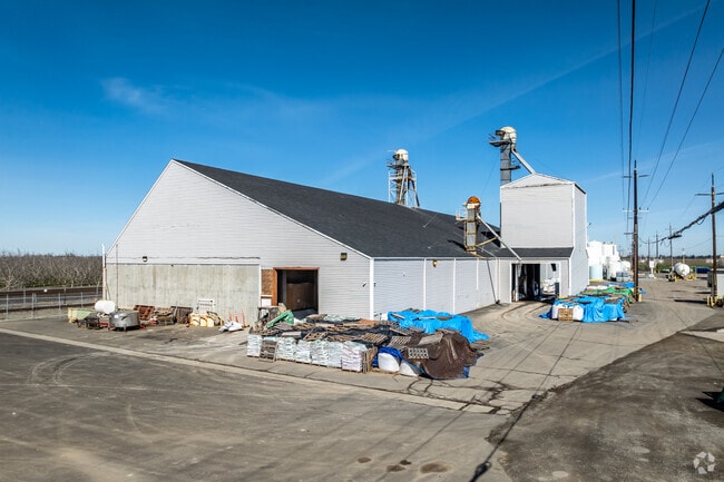
Warehouse
California
B and X Area of moderate flood hazard, usually the area between the limits of the 100-year and 500-year floods.
7.63 AC
2024
Vacaville
2025
North Bay/Santa Rosa
253300
NEARBY LISTINGS FOR SALE OR LEASE
-
-
View all Dixon listings for sale on LoopNet.com
DEMOGRAPHICS near 7235 Tremont Rd
1 mile
3 mile
5 mile
2025 Total Population
14
1,269
78,638
2030 Population
14
1,302
80,839
Pop Growth 2025-2030
0.00%
+ 2.60%
+ 2.80%
Average Age
40
27
34
2025 Total Households
5
272
26,548
HH Growth 2025-2030
0.00%
+ 1.84%
+ 2.70%
Median Household Inc
$87,500
$29,791
$78,650
Avg Household Size
2.40
2.50
2.50
2025 Avg HH Vehicles
3.00
2.00
2.00
Median Home Value
$999,999
$970,587
$762,103
Median Year Built
1954
1995
1982
Nearby Places
Map Layers
Map Styles
 Street
 Aerial
Layers
 Traffic
 Biking
Places
Listings with unknown addresses are not visible on the map
- Restaurants
- Banks
- Shops
- Fitness
- Groceries
PUBLIC TRANSPORTATION
COMMUTER RAIL
Davis (Capitol Corridor - Capitol Corridor Joint Powers Authority)
Drive
Walk
Distance
Davis (Capitol Corridor - Capitol Corridor Joint Powers Authority)
11 min
6.3 mi
AIRPORT
Sacramento International
Drive
Walk
Distance
Sacramento International
35 min
24.6 mi
Freight Ports
Port of Stockton
Drive
Walk
Distance
Port of Stockton
76 min
63.4 mi
Nearby Properties
Address
Land Use
TOTAL SIZE
Lot Size
Zoning
Address
Land Use
TOTAL SIZE
Lot Size
Zoning
34.71 AC
Address
Land Use
TOTAL SIZE
Lot Size
Zoning
56,534 SF
29.18 AC
Address
Land Use
TOTAL SIZE
Lot Size
Zoning
192,770 SF
20.56 AC
Address
Land Use
TOTAL SIZE
Lot Size
Zoning
330,554 SF
22.56 AC
INDUSTRIAL
Address
Land Use
TOTAL SIZE
Lot Size
Zoning
32.92 AC
Address
Land Use
TOTAL SIZE
Lot Size
Zoning
325,500 SF
25.73 AC
INDUSTRI
Address
Land Use
TOTAL SIZE
Lot Size
Zoning
60,627 SF
21.58 AC
Address
Land Use
TOTAL SIZE
Lot Size
Zoning
88.96 AC
Address
Land Use
TOTAL SIZE
Lot Size
Zoning
27.93 AC
Address
Land Use
TOTAL SIZE
Lot Size
Zoning
53,014 SF
41.31 AC
Address
Land Use
TOTAL SIZE
Lot Size
Zoning
17,408 SF
12.71 AC
Address
Land Use
TOTAL SIZE
Lot Size
Zoning
65.17 AC
A40
Address
Land Use
TOTAL SIZE
Lot Size
Zoning
101.33 AC
COMM IND A
Address
Land Use
TOTAL SIZE
Lot Size
Zoning
9.85 AC
CN - PD
Address
Land Use
TOTAL SIZE
Lot Size
Zoning
156.07 AC
A40
Address
Land Use
TOTAL SIZE
Lot Size
Zoning
37,908 SF
11.59 AC
Address
Land Use
TOTAL SIZE
Lot Size
Zoning
1 SF
13.41 AC
Address
Land Use
TOTAL SIZE
Lot Size
Zoning
25,747 SF
13.50 AC
Address
Land Use
TOTAL SIZE
Lot Size
Zoning
496.49 AC
Address
Land Use
TOTAL SIZE
Lot Size
Zoning
37.57 AC
Address
Land Use
TOTAL SIZE
Lot Size
Zoning
Address
Land Use
TOTAL SIZE
Lot Size
Zoning
13,163 SF
1.39 AC
RETAIL/COM
Address
Land Use
TOTAL SIZE
Lot Size
Zoning
2.01 AC
Address
Land Use
TOTAL SIZE
Lot Size
Zoning
41,592 SF
5 AC
MG
Address
Land Use
TOTAL SIZE
Lot Size
Zoning
52.73 AC
COMM IND A
Address
Land Use
TOTAL SIZE
Lot Size
Zoning
6.43 AC
INDUSTRIAL
Address
Land Use
TOTAL SIZE
Lot Size
Zoning
36.93 AC
4-40
Address
Land Use
TOTAL SIZE
Lot Size
Zoning
158.18 AC
A-40
Address
Land Use
TOTAL SIZE
Lot Size
Zoning
25,470 SF
39.86 AC
A-40
The World's #1 Commercial Real Estate Marketplace
Connect with us
© 2026 CoStar Group
The information above has been obtained from sources believed reliable. While we do not doubt its accuracy we have not verified it and make no guarantee, warranty or representation about it. It is your responsibility to independently confirm its accuracy and completeness. Any projections, opinions, assumptions, or estimates used are for example only and do not represent the current or future performance of the property. The value of this transaction to you depends on tax and other factors which should be evaluated by your tax, financial, and legal advisors. You and your advisors should conduct a careful, independent investigation of the property to determine to your satisfaction the suitability of the property for your needs.