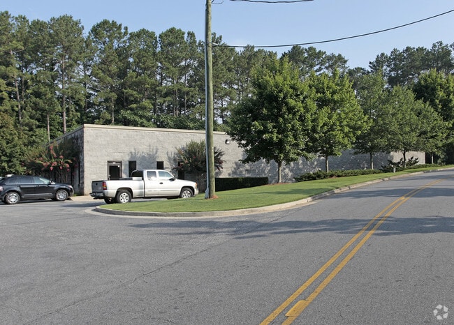
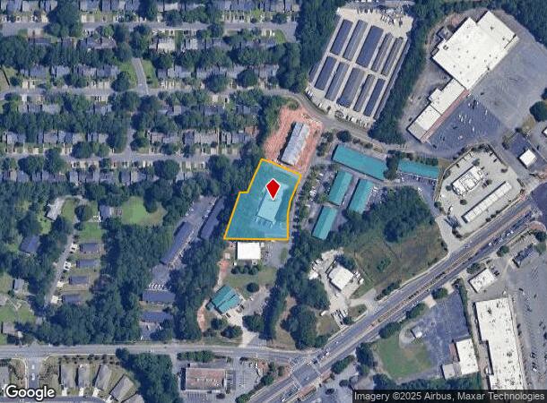
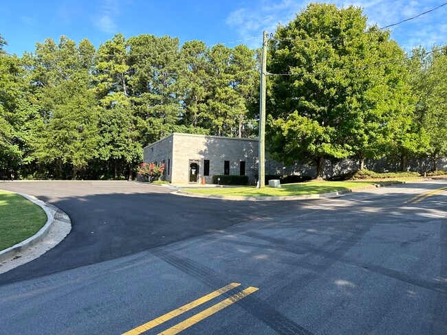
Property Record
718 Fairgate Rd Sw, Marietta, GA 30064
This Property Is For Sale
NEARBY LISTINGS FOR SALE OR LEASE
Property Detail
718 Fairgate Rd Sw
Warehouse
Cobb
X
Georgia
13067C0116J
1 AC
2025
SE Cobb Cnty/Marietta
2025
Atlanta
030912
Atlanta-Sandy Springs-Roswell, GA
8,400 SF
17-0147-0-148-0
DEMOGRAPHICS near 718 Fairgate Rd Sw
1 mile
3 mile
5 mile
2024 Total Population
10,961
69,196
207,867
2029 Population
11,239
70,763
212,453
Pop Growth 2024-2029
+ 2.54%
+ 2.26%
+ 2.21%
Average Age
37
37
37
2024 Total Households
4,282
25,883
81,708
HH Growth 2024-2029
+ 2.55%
+ 2.28%
+ 2.24%
Median Household Inc
$61,074
$63,190
$70,968
Avg Household Size
2.50
2.50
2.40
2024 Avg HH Vehicles
2.00
2.00
2.00
Median Home Value
$336,363
$333,604
$326,173
Median Year Built
1982
1981
1985
Nearby Places
Map Layers
Map Styles
 Street
 Aerial
Transit
 Traffic
 Biking
Places
Listings with unknown addresses are not visible on the map
- Restaurants
- Banks
- Shops
- Fitness
- Groceries
PUBLIC TRANSPORTATION
AIRPORT
Hartsfield - Jackson Atlanta International
Drive
Walk
Distance
Hartsfield - Jackson Atlanta International
43 min
28.4 mi
Nearby Properties
Address
Land Use
TOTAL SIZE
Lot Size
Zoning
Address
Land Use
TOTAL SIZE
Lot Size
Zoning
379,750 SF
11.14 AC
Address
Land Use
TOTAL SIZE
Lot Size
Zoning
8,000 SF
9.57 AC
PRD MF
Address
Land Use
TOTAL SIZE
Lot Size
Zoning
285,190 SF
25.16 AC
RM-12
Address
Land Use
TOTAL SIZE
Lot Size
Zoning
129,168 SF
0.82 AC
OI
Address
Land Use
TOTAL SIZE
Lot Size
Zoning
8,980 SF
51.17 AC
Address
Land Use
TOTAL SIZE
Lot Size
Zoning
225,315 SF
17.10 AC
RM-12
Address
Land Use
TOTAL SIZE
Lot Size
Zoning
236,808 SF
29.38 AC
PRD MF
Address
Land Use
TOTAL SIZE
Lot Size
Zoning
222,906 SF
18.96 AC
RM-12
Address
Land Use
TOTAL SIZE
Lot Size
Zoning
176,350 SF
19.56 AC
PRD MF
Address
Land Use
TOTAL SIZE
Lot Size
Zoning
143,362 SF
1.61 AC
OI
Address
Land Use
TOTAL SIZE
Lot Size
Zoning
187,972 SF
11.94 AC
RM-12
Address
Land Use
TOTAL SIZE
Lot Size
Zoning
213,318 SF
19.28 AC
PRD MF
Address
Land Use
TOTAL SIZE
Lot Size
Zoning
180,508 SF
21.88 AC
RM-8
Address
Land Use
TOTAL SIZE
Lot Size
Zoning
147,029 SF
3.05 AC
PRD MF
Address
Land Use
TOTAL SIZE
Lot Size
Zoning
217,980 SF
12.61 AC
PRD MF
Address
Land Use
TOTAL SIZE
Lot Size
Zoning
200,134 SF
12.60 AC
RM-8
Address
Land Use
TOTAL SIZE
Lot Size
Zoning
188,789 SF
8.88 AC
PRD MF
Address
Land Use
TOTAL SIZE
Lot Size
Zoning
289,582 SF
21.01 AC
RM-12
Address
Land Use
TOTAL SIZE
Lot Size
Zoning
132,810 SF
9.50 AC
RM-12
Address
Land Use
TOTAL SIZE
Lot Size
Zoning
425,800 SF
32.52 AC
HI
Address
Land Use
TOTAL SIZE
Lot Size
Zoning
133,813 SF
10 AC
RM-12
Address
Land Use
TOTAL SIZE
Lot Size
Zoning
127,776 SF
10.37 AC
RM-12
Address
Land Use
TOTAL SIZE
Lot Size
Zoning
77,699 SF
3.84 AC
O&I/WS
Address
Land Use
TOTAL SIZE
Lot Size
Zoning
112,766 SF
7.94 AC
RM-12
Address
Land Use
TOTAL SIZE
Lot Size
Zoning
208,355 SF
21.76 AC
CRC
Address
Land Use
TOTAL SIZE
Lot Size
Zoning
109,272 SF
10.20 AC
CRC
Address
Land Use
TOTAL SIZE
Lot Size
Zoning
72,572 SF
0.53 AC
OI
Address
Land Use
TOTAL SIZE
Lot Size
Zoning
113,652 SF
9.40 AC
RM-12
Address
Land Use
TOTAL SIZE
Lot Size
Zoning
131,802 SF
4.76 AC
RM-12
Address
Land Use
TOTAL SIZE
Lot Size
Zoning
157,524 SF
1.97 AC
OI
The World's #1 Commercial Real Estate Marketplace
Connect with us
© 2026 CoStar Group
The information above has been obtained from sources believed reliable. While we do not doubt its accuracy we have not verified it and make no guarantee, warranty or representation about it. It is your responsibility to independently confirm its accuracy and completeness. Any projections, opinions, assumptions, or estimates used are for example only and do not represent the current or future performance of the property. The value of this transaction to you depends on tax and other factors which should be evaluated by your tax, financial, and legal advisors. You and your advisors should conduct a careful, independent investigation of the property to determine to your satisfaction the suitability of the property for your needs.