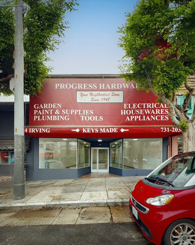
Property Record
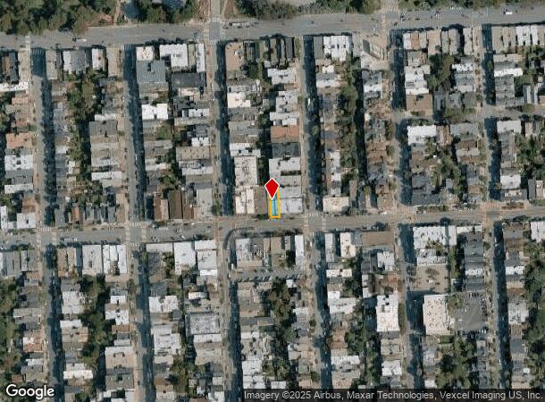
724 Irving St, San Francisco, CA 94122
Current Lease Availabilities
NEARBY LISTINGS FOR SALE OR LEASE
Property Detail
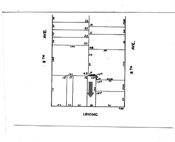
724 Irving St
San Francisco
Outside Land Bl 066
San Francisco-Redwood City-South San Francisco, CA
MAP D2 9
1742-015C
San Francisco
Storemultistory
California
2024
15c
2025
0.06 AC
030202
West of Van Ness
2,783 SF
DEMOGRAPHICS near 724 Irving St
1 Mile
3 Mile
5 Mile
2024 Total Population
49,707
432,892
820,981
2029 Population
46,144
400,569
759,776
Pop Growth 2024-2029
(7.17%)
(7.47%)
(7.46%)
Average Age
42
43
42
2024 Total Households
20,737
187,596
345,402
HH Growth 2024-2029
(7.73%)
(7.91%)
(7.80%)
Median Household Inc
$146,123
$141,626
$125,365
Avg Household Size
2.30
2.20
2.20
2024 Avg HH Vehicles
1.00
1.00
1.00
Median Home Value
$1,124,563
$1,115,424
$1,096,817
Median Year Built
1947
1948
1949
Nearby Places
- Restaurants
- Banks
- Shops
- Fitness
- Groceries
PUBLIC TRANSPORTATION
TRANSIT/SUBWAY
9th Ave & Irving St (N Judah - San Francisco Municipal Railway (MUNI Metro))
DRIVE
WALK
Distance
9th Ave & Irving St (N Judah - San Francisco Municipal Railway (MUNI Metro))
1 min
1 min
0.0 mi
Irving and 9th Avenue (N Judah - San Francisco Municipal Railway (MUNI Metro))
DRIVE
WALK
Distance
Irving and 9th Avenue (N Judah - San Francisco Municipal Railway (MUNI Metro))
1 min
1 min
0.0 mi
Irving St & 7th Ave (N Judah - San Francisco Municipal Railway (MUNI Metro))
DRIVE
WALK
Distance
Irving St & 7th Ave (N Judah - San Francisco Municipal Railway (MUNI Metro))
1 min
2 min
0.1 mi
Irving and 7th Avenue (N Judah - San Francisco Municipal Railway (MUNI Metro))
DRIVE
WALK
Distance
Irving and 7th Avenue (N Judah - San Francisco Municipal Railway (MUNI Metro))
1 min
2 min
0.1 mi
Judah and 9th Avenue (N Judah - San Francisco Municipal Railway (MUNI Metro))
DRIVE
WALK
Distance
Judah and 9th Avenue (N Judah - San Francisco Municipal Railway (MUNI Metro))
2 min
4 min
0.2 mi
COMMUTER RAIL
San Francisco 4th & King (Caltrain - Caltrain (Caltrain))
DRIVE
WALK
Distance
San Francisco 4th & King (Caltrain - Caltrain (Caltrain))
14 min
5.2 mi
22nd Street (Caltrain - Caltrain (Caltrain))
DRIVE
WALK
Distance
22nd Street (Caltrain - Caltrain (Caltrain))
18 min
6.7 mi
AIRPORT
San Francisco International
DRIVE
WALK
Distance
San Francisco International
25 min
15.0 mi
Metro Oakland International
DRIVE
WALK
Distance
Metro Oakland International
38 min
23.5 mi
Norman Y Mineta San Jose International
DRIVE
WALK
Distance
Norman Y Mineta San Jose International
55 min
46.6 mi
Nearby Properties
Address
Land Use
TOTAL SIZE
Lot Size
Zoning
Address
Land Use
TOTAL SIZE
Lot Size
Zoning
1,015,000 SF
2.43 AC
RC4
Address
Land Use
TOTAL SIZE
Lot Size
Zoning
248,303 SF
4.35 AC
Address
Land Use
TOTAL SIZE
Lot Size
Zoning
1.52 AC
C3G
Address
Land Use
TOTAL SIZE
Lot Size
Zoning
24.37 AC
Address
Land Use
TOTAL SIZE
Lot Size
Zoning
342,727 SF
1.36 AC
C3G
Address
Land Use
TOTAL SIZE
Lot Size
Zoning
411,904 SF
21.74 AC
C2
Address
Land Use
TOTAL SIZE
Lot Size
Zoning
291,522 SF
6.66 AC
CM
Address
Land Use
TOTAL SIZE
Lot Size
Zoning
718 SF
18.55 AC
RH2
Address
Land Use
TOTAL SIZE
Lot Size
Zoning
246,069 SF
0.69 AC
Address
Land Use
TOTAL SIZE
Lot Size
Zoning
89,551 SF
0.73 AC
RC4
Address
Land Use
TOTAL SIZE
Lot Size
Zoning
450,000 SF
1.07 AC
C3G
Address
Land Use
TOTAL SIZE
Lot Size
Zoning
337,664 SF
0.36 AC
C3G
Address
Land Use
TOTAL SIZE
Lot Size
Zoning
409,895 SF
7.20 AC
RH3
Address
Land Use
TOTAL SIZE
Lot Size
Zoning
741,667 SF
1.96 AC
C3G
Address
Land Use
TOTAL SIZE
Lot Size
Zoning
241,907 SF
0.82 AC
C3G
Address
Land Use
TOTAL SIZE
Lot Size
Zoning
524,271 SF
1.06 AC
RC4
Address
Land Use
TOTAL SIZE
Lot Size
Zoning
2.40 AC
NC3
Address
Land Use
TOTAL SIZE
Lot Size
Zoning
1,320,000 SF
3.01 AC
C3G
Address
Land Use
TOTAL SIZE
Lot Size
Zoning
250,843 SF
6.62 AC
NC3
Address
Land Use
TOTAL SIZE
Lot Size
Zoning
151,084 SF
1.35 AC
Address
Land Use
TOTAL SIZE
Lot Size
Zoning
Address
Land Use
TOTAL SIZE
Lot Size
Zoning
3 AC
C3G
Address
Land Use
TOTAL SIZE
Lot Size
Zoning
225,851 SF
1.19 AC
NCT1
Address
Land Use
TOTAL SIZE
Lot Size
Zoning
1.68 AC
RM2
Address
Land Use
TOTAL SIZE
Lot Size
Zoning
314,600 SF
0.62 AC
C3G
Address
Land Use
TOTAL SIZE
Lot Size
Zoning
162,220 SF
0.51 AC
C3G
Address
Land Use
TOTAL SIZE
Lot Size
Zoning
17.91 AC
RH-2
Address
Land Use
TOTAL SIZE
Lot Size
Zoning
126,849 SF
0.60 AC
CM
Address
Land Use
TOTAL SIZE
Lot Size
Zoning
420,000 SF
0.79 AC
NC-3
Address
Land Use
TOTAL SIZE
Lot Size
Zoning
257,526 SF
1.31 AC
C3G
The World's #1 Commercial Real Estate Marketplace
Connect with us
© 2025 CoStar Group
The information above has been obtained from sources believed reliable. While we do not doubt its accuracy we have not verified it and make no guarantee, warranty or representation about it. It is your responsibility to independently confirm its accuracy and completeness. Any projections, opinions, assumptions, or estimates used are for example only and do not represent the current or future performance of the property. The value of this transaction to you depends on tax and other factors which should be evaluated by your tax, financial, and legal advisors. You and your advisors should conduct a careful, independent investigation of the property to determine to your satisfaction the suitability of the property for your needs.