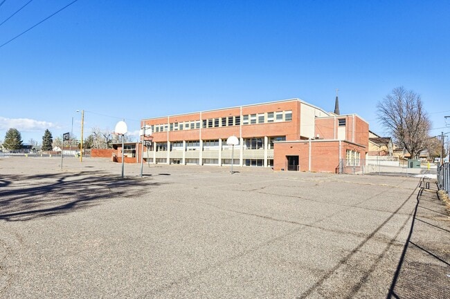
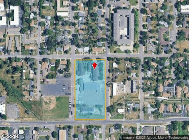
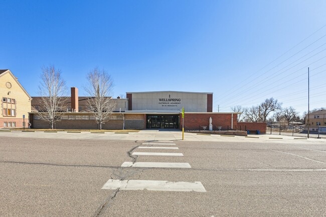
Property Record
7240 W 12Th Ave, Lakewood, CO 80214
Current Lease Availabilities
NEARBY LISTINGS FOR SALE OR LEASE
Property Detail
7240 W 12Th Ave
49-021-20-001
Lakewood
Commercialnec
SECTION 02 TOWNSHIP 04 RANGE 69 QTR NE SUBDIVISIONCD 442600 SUBDIVISIONNAME LAKEWOOD BLOCK 052 LOT SIZE: 152939 TRACT VALUE: 3.511 SECTION 02 TOWNSHIP 04 RANGE 69 QTR NE SUBDIVISIONCD 442600 SUBDIVISIONNAME LAKEWOOD BLOCK 052 LOT SIZE: 11500 TRACT 0S
AE
Jefferson
08059C0302G
Colorado
0
3.78 AC
2024
West Denver
011551
Denver
75,962 SF
Denver-Aurora-Centennial, CO
DEMOGRAPHICS near 7240 W 12Th Ave
1 Mile
3 Mile
5 Mile
2024 Total Population
16,031
148,500
407,139
2029 Population
16,085
149,185
409,131
Pop Growth 2024-2029
+ 0.34%
+ 0.46%
+ 0.49%
Average Age
40
39
39
2024 Total Households
7,282
62,988
179,832
HH Growth 2024-2029
+ 0.11%
+ 0.50%
+ 0.67%
Median Household Inc
$53,859
$70,140
$80,157
Avg Household Size
2.00
2.20
2.20
2024 Avg HH Vehicles
2.00
2.00
2.00
Median Home Value
$471,428
$505,983
$527,242
Median Year Built
1971
1965
1971
Nearby Places
Map Layers
Map Styles
 Street
 Aerial
- Restaurants
- Banks
- Shops
- Fitness
- Groceries
PUBLIC TRANSPORTATION
TRANSIT/SUBWAY
Lakewood/Wadsworth (W Line - Denver Regional Transportation District Light Rail (TheRide))
DRIVE
WALK
Distance
Lakewood/Wadsworth (W Line - Denver Regional Transportation District Light Rail (TheRide))
1 min
8 min
0.4 mi
Lamar (W Line - Denver Regional Transportation District Light Rail (TheRide))
DRIVE
WALK
Distance
Lamar (W Line - Denver Regional Transportation District Light Rail (TheRide))
2 min
15 min
0.8 mi
COMMUTER RAIL
Union Station: Lodo-Coors Field-16Th Street Mall (C Line - Denver Regional Transportation District Light Rail (TheRide), E Line - Denver Regional Transportation District Light Rail (TheRide), W Line - Denver Regional Transportation District Light Rail (TheRide))
DRIVE
WALK
Distance
Union Station: Lodo-Coors Field-16Th Street Mall (C Line - Denver Regional Transportation District Light Rail (TheRide), E Line - Denver Regional Transportation District Light Rail (TheRide), W Line - Denver Regional Transportation District Light Rail (TheRide))
12 min
7.0 mi
Denver (California Zephyr - Amtrak)
DRIVE
WALK
Distance
Denver (California Zephyr - Amtrak)
13 min
7.2 mi
AIRPORT
Denver International
DRIVE
WALK
Distance
Denver International
41 min
30.9 mi
Freight Ports
Tulsa Port Of Catoosa
DRIVE
WALK
Distance
Tulsa Port Of Catoosa
738 min
716.4 mi
Nearby Properties
Address
Land Use
TOTAL SIZE
Lot Size
Zoning
Address
Land Use
TOTAL SIZE
Lot Size
Zoning
3,195,026 SF
562.97 AC
Address
Land Use
TOTAL SIZE
Lot Size
Zoning
333,925 SF
3.34 AC
C-MX-5
Address
Land Use
TOTAL SIZE
Lot Size
Zoning
111,673 SF
29.06 AC
Address
Land Use
TOTAL SIZE
Lot Size
Zoning
232,678 SF
27.50 AC
Address
Land Use
TOTAL SIZE
Lot Size
Zoning
175,000 SF
2.99 AC
C-MX
Address
Land Use
TOTAL SIZE
Lot Size
Zoning
233,688 SF
22.37 AC
Address
Land Use
TOTAL SIZE
Lot Size
Zoning
325,844 SF
4.08 AC
C-MX-12
Address
Land Use
TOTAL SIZE
Lot Size
Zoning
199,685 SF
27.73 AC
Address
Land Use
TOTAL SIZE
Lot Size
Zoning
187,095 SF
23.42 AC
Address
Land Use
TOTAL SIZE
Lot Size
Zoning
247,459 SF
2.31 AC
C-MX-8
Address
Land Use
TOTAL SIZE
Lot Size
Zoning
188,297 SF
2.11 AC
R-MU-30
Address
Land Use
TOTAL SIZE
Lot Size
Zoning
202,867 SF
2.28 AC
C-MX
Address
Land Use
TOTAL SIZE
Lot Size
Zoning
238,452 SF
8.03 AC
Address
Land Use
TOTAL SIZE
Lot Size
Zoning
212,995 SF
3.20 AC
R-3
Address
Land Use
TOTAL SIZE
Lot Size
Zoning
135,372 SF
11.66 AC
Address
Land Use
TOTAL SIZE
Lot Size
Zoning
167,420 SF
5.84 AC
Address
Land Use
TOTAL SIZE
Lot Size
Zoning
100,615 SF
2.28 AC
Address
Land Use
TOTAL SIZE
Lot Size
Zoning
82,756 SF
14.95 AC
Address
Land Use
TOTAL SIZE
Lot Size
Zoning
86,431 SF
6.48 AC
G-MU-3
Address
Land Use
TOTAL SIZE
Lot Size
Zoning
311,200 SF
0.85 AC
Address
Land Use
TOTAL SIZE
Lot Size
Zoning
174,060 SF
2.24 AC
U-SU-C
Address
Land Use
TOTAL SIZE
Lot Size
Zoning
138,204 SF
3.68 AC
Address
Land Use
TOTAL SIZE
Lot Size
Zoning
146,133 SF
3.75 AC
Address
Land Use
TOTAL SIZE
Lot Size
Zoning
330,357 SF
15.16 AC
Address
Land Use
TOTAL SIZE
Lot Size
Zoning
111,478 SF
8.24 AC
CMP
Address
Land Use
TOTAL SIZE
Lot Size
Zoning
241,243 SF
9.08 AC
Address
Land Use
TOTAL SIZE
Lot Size
Zoning
41,263 SF
7.94 AC
Address
Land Use
TOTAL SIZE
Lot Size
Zoning
221,088 SF
12.84 AC
Address
Land Use
TOTAL SIZE
Lot Size
Zoning
227,321 SF
5.65 AC
R-3
Address
Land Use
TOTAL SIZE
Lot Size
Zoning
342,370 SF
2.52 AC
C-MX-5
The World's #1 Commercial Real Estate Marketplace
Connect with us
© 2026 CoStar Group
The information above has been obtained from sources believed reliable. While we do not doubt its accuracy we have not verified it and make no guarantee, warranty or representation about it. It is your responsibility to independently confirm its accuracy and completeness. Any projections, opinions, assumptions, or estimates used are for example only and do not represent the current or future performance of the property. The value of this transaction to you depends on tax and other factors which should be evaluated by your tax, financial, and legal advisors. You and your advisors should conduct a careful, independent investigation of the property to determine to your satisfaction the suitability of the property for your needs.