Property Record
7241 Baxter Grade Rd, Auburn, CA 95603


NEARBY LISTINGS FOR SALE OR LEASE
-
-
View all Auburn listings for sale on LoopNet.com
Property Detail
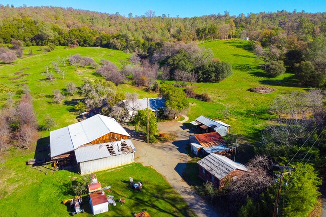
7241 Baxter Grade Rd
026-212-021
Heredia Estate
Orchard
42.0 AC SEC 35 13 7
X
Placer
06061C0745H
California
2024
42 AC
2025
Auburn/Lincoln
021604
Sacramento
1,512 SF
Sacramento--Roseville--Arden-Arcade, CA
DEMOGRAPHICS near 7241 Baxter Grade Rd
1 Mile
3 Mile
5 Mile
2024 Total Population
400
5,553
26,468
2029 Population
426
5,944
28,389
Pop Growth 2024-2029
+ 6.50%
+ 7.04%
+ 7.26%
Average Age
48
48
46
2024 Total Households
146
2,113
10,364
HH Growth 2024-2029
+ 6.85%
+ 7.05%
+ 7.33%
Median Household Inc
$90,517
$100,950
$87,955
Avg Household Size
2.60
2.50
2.40
2024 Avg HH Vehicles
3.00
3.00
2.00
Median Home Value
$761,574
$762,142
$644,669
Median Year Built
1983
1982
1980
Nearby Places
Map Layers
Map Styles
 Street
 Aerial
- Restaurants
- Banks
- Shops
- Fitness
- Groceries
PUBLIC TRANSPORTATION
COMMUTER RAIL
Auburn-Conheim (Capitol Corridor - Capitol Corridor Joint Powers Authority)
DRIVE
WALK
Distance
Auburn-Conheim (Capitol Corridor - Capitol Corridor Joint Powers Authority)
17 min
6.6 mi
Auburn Amtrak (Capitol Corridor - Amtrak)
DRIVE
WALK
Distance
Auburn Amtrak (Capitol Corridor - Amtrak)
17 min
6.6 mi
AIRPORT
Sacramento International
DRIVE
WALK
Distance
Sacramento International
60 min
42.3 mi
Freight Ports
Port of Stockton
DRIVE
WALK
Distance
Port of Stockton
102 min
82.5 mi
SALE & LEASE HISTORY
LISTING DATE
SALE/LEASE

Jan 10, 2022
For Sale
Nearby Properties
Address
Land Use
TOTAL SIZE
Lot Size
Zoning
Address
Land Use
TOTAL SIZE
Lot Size
Zoning
6,312 SF
20 AC
FBX
Address
Land Use
TOTAL SIZE
Lot Size
Zoning
3,282 SF
30.10 AC
FBX
Address
Land Use
TOTAL SIZE
Lot Size
Zoning
5,670 SF
24.10 AC
FBX
Address
Land Use
TOTAL SIZE
Lot Size
Zoning
3,382 SF
31.30 AC
FBX
Address
Land Use
TOTAL SIZE
Lot Size
Zoning
1,198 SF
10.70 AC
RAB100
Address
Land Use
TOTAL SIZE
Lot Size
Zoning
3,579 SF
10 AC
FBX
Address
Land Use
TOTAL SIZE
Lot Size
Zoning
2,712 SF
20.60 AC
F
Address
Land Use
TOTAL SIZE
Lot Size
Zoning
2,044 SF
28.90 AC
FBX
Address
Land Use
TOTAL SIZE
Lot Size
Zoning
1,250 SF
17.90 AC
FBX
Address
Land Use
TOTAL SIZE
Lot Size
Zoning
4,078 SF
5.40 AC
RSAGB40
Address
Land Use
TOTAL SIZE
Lot Size
Zoning
1,140 SF
31.30 AC
Address
Land Use
TOTAL SIZE
Lot Size
Zoning
2,850 SF
5.80 AC
FBX
Address
Land Use
TOTAL SIZE
Lot Size
Zoning
4,960 SF
12.30 AC
AE
Address
Land Use
TOTAL SIZE
Lot Size
Zoning
2,994 SF
23.30 AC
AE
Address
Land Use
TOTAL SIZE
Lot Size
Zoning
3,218 SF
11 AC
FBX
Address
Land Use
TOTAL SIZE
Lot Size
Zoning
2,939 SF
30.40 AC
FBX
Address
Land Use
TOTAL SIZE
Lot Size
Zoning
1,797 SF
4.40 AC
RAB100
Address
Land Use
TOTAL SIZE
Lot Size
Zoning
10.80 AC
FBX
Address
Land Use
TOTAL SIZE
Lot Size
Zoning
2,451 SF
20 AC
FBX
Address
Land Use
TOTAL SIZE
Lot Size
Zoning
1,984 SF
6.70 AC
FBX
Address
Land Use
TOTAL SIZE
Lot Size
Zoning
1,344 SF
119.80 AC
FBX
Address
Land Use
TOTAL SIZE
Lot Size
Zoning
2,428 SF
41.84 AC
FBX
Address
Land Use
TOTAL SIZE
Lot Size
Zoning
3,626 SF
9.70 AC
FBX
Address
Land Use
TOTAL SIZE
Lot Size
Zoning
4,140 SF
4.43 AC
RAB100
Address
Land Use
TOTAL SIZE
Lot Size
Zoning
Address
Land Use
TOTAL SIZE
Lot Size
Zoning
10 AC
FBX
Address
Land Use
TOTAL SIZE
Lot Size
Zoning
2,000 SF
20.80 AC
F
Address
Land Use
TOTAL SIZE
Lot Size
Zoning
2,854 SF
30 AC
FBX
The World's #1 Commercial Real Estate Marketplace
Connect with us
© 2025 CoStar Group
The information above has been obtained from sources believed reliable. While we do not doubt its accuracy we have not verified it and make no guarantee, warranty or representation about it. It is your responsibility to independently confirm its accuracy and completeness. Any projections, opinions, assumptions, or estimates used are for example only and do not represent the current or future performance of the property. The value of this transaction to you depends on tax and other factors which should be evaluated by your tax, financial, and legal advisors. You and your advisors should conduct a careful, independent investigation of the property to determine to your satisfaction the suitability of the property for your needs.