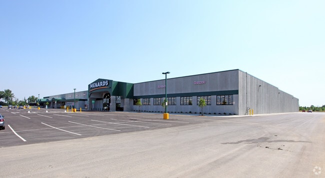
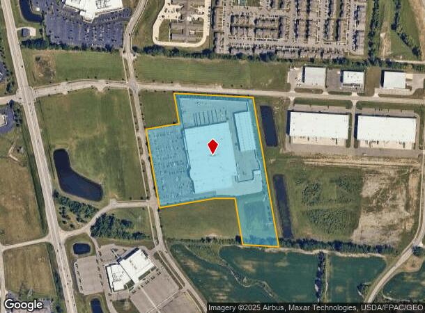
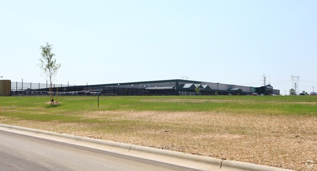
Property Record
7241 Graphics Way, Lewis Center, OH 43035
NEARBY LISTINGS FOR SALE OR LEASE
Property Detail
7241 Graphics Way
318-230-01-003-012
LOT 7760 MENARDS CREEKSIDE
Departmentstore
Delaware
X
Ohio
39041C0242K
7760
2024
21.10 AC
2024
Outlying Delaware County
011563
Columbus
177,535 SF
Columbus, OH
DEMOGRAPHICS near 7241 Graphics Way
1 Mile
3 Mile
5 Mile
2024 Total Population
2,771
42,657
132,741
2029 Population
3,132
48,471
146,536
Pop Growth 2024-2029
+ 13.03%
+ 13.63%
+ 10.39%
Average Age
41
37
37
2024 Total Households
958
14,432
48,487
HH Growth 2024-2029
+ 13.15%
+ 13.73%
+ 10.04%
Median Household Inc
$118,564
$141,690
$125,478
Avg Household Size
2.80
2.90
2.70
2024 Avg HH Vehicles
2.00
2.00
2.00
Median Home Value
$400,806
$396,382
$392,153
Median Year Built
2007
2002
1999
Nearby Places
Map Layers
Map Styles
 Street
 Aerial
- Restaurants
- Banks
- Shops
- Fitness
- Groceries
PUBLIC TRANSPORTATION
AIRPORT
John Glenn Columbus International
DRIVE
WALK
Distance
John Glenn Columbus International
32 min
20.9 mi
Rickenbacker International
DRIVE
WALK
Distance
Rickenbacker International
50 min
32.5 mi
Nearby Properties
Address
Land Use
TOTAL SIZE
Lot Size
Zoning
Address
Land Use
TOTAL SIZE
Lot Size
Zoning
304,275 SF
52.13 AC
Address
Land Use
TOTAL SIZE
Lot Size
Zoning
519,213 SF
132.66 AC
Address
Land Use
TOTAL SIZE
Lot Size
Zoning
44,795 SF
418.88 AC
Address
Land Use
TOTAL SIZE
Lot Size
Zoning
46,994 SF
27.37 AC
Address
Land Use
TOTAL SIZE
Lot Size
Zoning
295,163 SF
16.04 AC
Address
Land Use
TOTAL SIZE
Lot Size
Zoning
577,104 SF
31.05 AC
Address
Land Use
TOTAL SIZE
Lot Size
Zoning
116,682 SF
11.43 AC
Address
Land Use
TOTAL SIZE
Lot Size
Zoning
266,792 SF
9.03 AC
Address
Land Use
TOTAL SIZE
Lot Size
Zoning
428,656 SF
6.42 AC
Address
Land Use
TOTAL SIZE
Lot Size
Zoning
70,648 SF
15.50 AC
Address
Land Use
TOTAL SIZE
Lot Size
Zoning
219,449 SF
28.68 AC
Address
Land Use
TOTAL SIZE
Lot Size
Zoning
174,192 SF
11 AC
Address
Land Use
TOTAL SIZE
Lot Size
Zoning
240,300 SF
12.50 AC
Address
Land Use
TOTAL SIZE
Lot Size
Zoning
47,763 SF
21.77 AC
Address
Land Use
TOTAL SIZE
Lot Size
Zoning
243,440 SF
12.50 AC
Address
Land Use
TOTAL SIZE
Lot Size
Zoning
47,996 SF
14.27 AC
Address
Land Use
TOTAL SIZE
Lot Size
Zoning
89,364 SF
106.80 AC
Address
Land Use
TOTAL SIZE
Lot Size
Zoning
141,891 SF
43 AC
Address
Land Use
TOTAL SIZE
Lot Size
Zoning
26,534 SF
17.75 AC
Address
Land Use
TOTAL SIZE
Lot Size
Zoning
153,766 SF
3.98 AC
Address
Land Use
TOTAL SIZE
Lot Size
Zoning
73,101 SF
17.77 AC
Address
Land Use
TOTAL SIZE
Lot Size
Zoning
45,711 SF
3.81 AC
Address
Land Use
TOTAL SIZE
Lot Size
Zoning
47,589 SF
0.90 AC
Address
Land Use
TOTAL SIZE
Lot Size
Zoning
102,588 SF
24.40 AC
Address
Land Use
TOTAL SIZE
Lot Size
Zoning
74,904 SF
2.81 AC
Address
Land Use
TOTAL SIZE
Lot Size
Zoning
6,676 SF
478.74 AC
Address
Land Use
TOTAL SIZE
Lot Size
Zoning
202,966 SF
16.83 AC
Address
Land Use
TOTAL SIZE
Lot Size
Zoning
95,549 SF
8.23 AC
Address
Land Use
TOTAL SIZE
Lot Size
Zoning
210,364 SF
34.55 AC
Address
Land Use
TOTAL SIZE
Lot Size
Zoning
102,204 SF
11.44 AC
The World's #1 Commercial Real Estate Marketplace
Connect with us
© 2026 CoStar Group
The information above has been obtained from sources believed reliable. While we do not doubt its accuracy we have not verified it and make no guarantee, warranty or representation about it. It is your responsibility to independently confirm its accuracy and completeness. Any projections, opinions, assumptions, or estimates used are for example only and do not represent the current or future performance of the property. The value of this transaction to you depends on tax and other factors which should be evaluated by your tax, financial, and legal advisors. You and your advisors should conduct a careful, independent investigation of the property to determine to your satisfaction the suitability of the property for your needs.