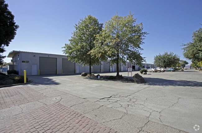
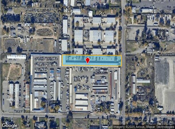
Property Record
7245 32Nd St, North Highlands, CA 95660

Current Lease Availabilities
NEARBY LISTINGS FOR SALE OR LEASE
Property Detail
7245 32Nd St
Sacramento-Roseville-Folsom, CA
Rio Linda Sub 6
208-0082-004
N 132 FT OF LOT 29 RIO LINDA SUB NO 6
Multitenantindustrial
Sacramento
X
California
06061C1010H
29
2024
1.91 AC
2025
McClellan
007435
Sacramento
27,440 SF
DEMOGRAPHICS near 7245 32Nd St
1 Mile
3 Mile
5 Mile
2024 Total Population
9,759
109,300
248,012
2029 Population
9,743
109,590
250,337
Pop Growth 2024-2029
(0.16%)
+ 0.27%
+ 0.94%
Average Age
37
36
38
2024 Total Households
3,005
34,755
84,117
HH Growth 2024-2029
(0.23%)
+ 0.21%
+ 0.91%
Median Household Inc
$64,236
$72,049
$73,081
Avg Household Size
3.20
3.10
2.90
2024 Avg HH Vehicles
2.00
2.00
2.00
Median Home Value
$370,055
$376,995
$401,761
Median Year Built
1975
1981
1978
Nearby Places
Map Layers
Map Styles
 Street
 Aerial
- Restaurants
- Banks
- Shops
- Fitness
- Groceries
PUBLIC TRANSPORTATION
COMMUTER RAIL
Roseville (California Zephyr - Amtrak, Capitol Corridor - Amtrak)
DRIVE
WALK
Distance
Roseville (California Zephyr - Amtrak, Capitol Corridor - Amtrak)
16 min
8.4 mi
AIRPORT
Sacramento International
DRIVE
WALK
Distance
Sacramento International
24 min
14.4 mi
Freight Ports
Port of Stockton
DRIVE
WALK
Distance
Port of Stockton
74 min
60.4 mi
Nearby Properties
Address
Land Use
TOTAL SIZE
Lot Size
Zoning
Address
Land Use
TOTAL SIZE
Lot Size
Zoning
430,406 SF
24.45 AC
RD-20
Address
Land Use
TOTAL SIZE
Lot Size
Zoning
173,174 SF
8.89 AC
RD-30
Address
Land Use
TOTAL SIZE
Lot Size
Zoning
183,000 SF
12.49 AC
RD-20
Address
Land Use
TOTAL SIZE
Lot Size
Zoning
14.88 AC
RD-20
Address
Land Use
TOTAL SIZE
Lot Size
Zoning
170,556 SF
8.41 AC
SPA
Address
Land Use
TOTAL SIZE
Lot Size
Zoning
217,380 SF
10 AC
SPA
Address
Land Use
TOTAL SIZE
Lot Size
Zoning
200,104 SF
13.85 AC
RD-20
Address
Land Use
TOTAL SIZE
Lot Size
Zoning
263,792 SF
7.27 AC
SPA
Address
Land Use
TOTAL SIZE
Lot Size
Zoning
130,507 SF
8.97 AC
RD-20
Address
Land Use
TOTAL SIZE
Lot Size
Zoning
146,283 SF
8.73 AC
RD-20
Address
Land Use
TOTAL SIZE
Lot Size
Zoning
244,048 SF
13.38 AC
RD-30
Address
Land Use
TOTAL SIZE
Lot Size
Zoning
160,497 SF
6.85 AC
RD-30
Address
Land Use
TOTAL SIZE
Lot Size
Zoning
0.16 AC
RD-5
Address
Land Use
TOTAL SIZE
Lot Size
Zoning
280,864 SF
14.94 AC
RD-20
Address
Land Use
TOTAL SIZE
Lot Size
Zoning
288,524 SF
11.64 AC
M-1
Address
Land Use
TOTAL SIZE
Lot Size
Zoning
141,274 SF
7.06 AC
RD-20
Address
Land Use
TOTAL SIZE
Lot Size
Zoning
185,342 SF
11.13 AC
RD-20
Address
Land Use
TOTAL SIZE
Lot Size
Zoning
0.13 AC
RD-7
Address
Land Use
TOTAL SIZE
Lot Size
Zoning
81,124 SF
4.81 AC
RD-20
Address
Land Use
TOTAL SIZE
Lot Size
Zoning
100,529 SF
13.65 AC
RD-10 BP
Address
Land Use
TOTAL SIZE
Lot Size
Zoning
124,819 SF
13.10 AC
SC
Address
Land Use
TOTAL SIZE
Lot Size
Zoning
250,000 SF
13.90 AC
M-1
Address
Land Use
TOTAL SIZE
Lot Size
Zoning
194,580 SF
9.66 AC
RD-30
Address
Land Use
TOTAL SIZE
Lot Size
Zoning
106,370 SF
5.91 AC
RD-30
Address
Land Use
TOTAL SIZE
Lot Size
Zoning
Address
Land Use
TOTAL SIZE
Lot Size
Zoning
2.76 AC
SPA
Address
Land Use
TOTAL SIZE
Lot Size
Zoning
576,506 SF
21.22 AC
SPA
Address
Land Use
TOTAL SIZE
Lot Size
Zoning
91,526 SF
7.45 AC
SC
Address
Land Use
TOTAL SIZE
Lot Size
Zoning
149,950 SF
10.50 AC
RD-20
Address
Land Use
TOTAL SIZE
Lot Size
Zoning
176,184 SF
7.77 AC
RD-20
The World's #1 Commercial Real Estate Marketplace
Connect with us
© 2026 CoStar Group
The information above has been obtained from sources believed reliable. While we do not doubt its accuracy we have not verified it and make no guarantee, warranty or representation about it. It is your responsibility to independently confirm its accuracy and completeness. Any projections, opinions, assumptions, or estimates used are for example only and do not represent the current or future performance of the property. The value of this transaction to you depends on tax and other factors which should be evaluated by your tax, financial, and legal advisors. You and your advisors should conduct a careful, independent investigation of the property to determine to your satisfaction the suitability of the property for your needs.