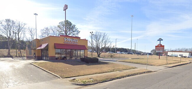
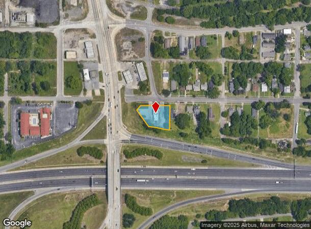
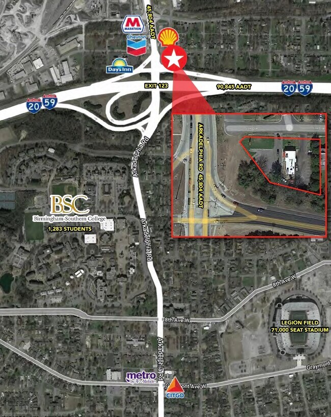
Property Record
725 11Th Ct W, Birmingham, AL 35204
NEARBY LISTINGS FOR SALE OR LEASE
Property Detail
725 11Th Ct W
Birmingham-Hoover, AL
Norris-Spaulding 22-28-4
22-00-28-4-042-001.501
LOT 8-A NORRIS AD TO SPAULDING 106/1 LESS PT IN RD R/W ALSO LOT 7 BLK 12 SPAULDING 1/261
Restaurantbuilding
Jefferson
X
Alabama
01073C0388H
8-a,7
2023
0.45 AC
2024
Fultondale
0014003029
Birmingham
DEMOGRAPHICS near 725 11Th Ct W
1 Mile
3 Mile
5 Mile
2024 Total Population
7,141
62,596
162,232
2029 Population
7,180
63,729
162,679
Pop Growth 2024-2029
+ 0.55%
+ 1.81%
+ 0.28%
Average Age
39
41
39
2024 Total Households
2,687
27,875
71,436
HH Growth 2024-2029
+ 0.93%
+ 1.94%
+ 0.35%
Median Household Inc
$35,554
$32,392
$39,502
Avg Household Size
2.10
2.00
2.10
2024 Avg HH Vehicles
1.00
1.00
1.00
Median Home Value
$79,404
$82,630
$120,773
Median Year Built
1953
1963
1964
Nearby Places
Map Layers
Map Styles
 Street
 Aerial
- Restaurants
- Banks
- Shops
- Fitness
- Groceries
PUBLIC TRANSPORTATION
AIRPORT
Birmingham-Shuttlesworth International
DRIVE
WALK
Distance
Birmingham-Shuttlesworth International
13 min
8.5 mi
SALE & LEASE HISTORY
LISTING DATE
SALE/LEASE

Jun 07, 2023
For Lease
Nearby Properties
Address
Land Use
TOTAL SIZE
Lot Size
Zoning
Address
Land Use
TOTAL SIZE
Lot Size
Zoning
305,826 SF
3.68 AC
B4
Address
Land Use
TOTAL SIZE
Lot Size
Zoning
189,447 SF
3.67 AC
B4
Address
Land Use
TOTAL SIZE
Lot Size
Zoning
224,049 SF
4.33 AC
M1
Address
Land Use
TOTAL SIZE
Lot Size
Zoning
239,334 SF
4.42 AC
B6
Address
Land Use
TOTAL SIZE
Lot Size
Zoning
203,878 SF
12.58 AC
B6
Address
Land Use
TOTAL SIZE
Lot Size
Zoning
230,441 SF
10.22 AC
M1
Address
Land Use
TOTAL SIZE
Lot Size
Zoning
183,862 SF
9.66 AC
B4
Address
Land Use
TOTAL SIZE
Lot Size
Zoning
334,463 SF
1.92 AC
B4
Address
Land Use
TOTAL SIZE
Lot Size
Zoning
94,958 SF
4.47 AC
M1
Address
Land Use
TOTAL SIZE
Lot Size
Zoning
106,144 SF
1.09 AC
B4
Address
Land Use
TOTAL SIZE
Lot Size
Zoning
57,066 SF
0.80 AC
B4
Address
Land Use
TOTAL SIZE
Lot Size
Zoning
79,458 SF
1.37 AC
B4
Address
Land Use
TOTAL SIZE
Lot Size
Zoning
229,669 SF
2.75 AC
B4
Address
Land Use
TOTAL SIZE
Lot Size
Zoning
109,411 SF
2.77 AC
B4
Address
Land Use
TOTAL SIZE
Lot Size
Zoning
344,150 SF
42 AC
R5
Address
Land Use
TOTAL SIZE
Lot Size
Zoning
1.66 AC
M1-B
Address
Land Use
TOTAL SIZE
Lot Size
Zoning
1,666 SF
1.69 AC
M1
Address
Land Use
TOTAL SIZE
Lot Size
Zoning
1.54 AC
B4
Address
Land Use
TOTAL SIZE
Lot Size
Zoning
29,136 SF
1.58 AC
B4
Address
Land Use
TOTAL SIZE
Lot Size
Zoning
37,733 SF
0.84 AC
B-4
Address
Land Use
TOTAL SIZE
Lot Size
Zoning
416,477 SF
80 AC
R5
Address
Land Use
TOTAL SIZE
Lot Size
Zoning
109,819 SF
2.91 AC
M2
Address
Land Use
TOTAL SIZE
Lot Size
Zoning
37,640 SF
1.76 AC
B4
Address
Land Use
TOTAL SIZE
Lot Size
Zoning
111,309 SF
1.29 AC
B-4
Address
Land Use
TOTAL SIZE
Lot Size
Zoning
120,768 SF
1.75 AC
B4
Address
Land Use
TOTAL SIZE
Lot Size
Zoning
156,986 SF
1.29 AC
M1
Address
Land Use
TOTAL SIZE
Lot Size
Zoning
1.69 AC
B4
Address
Land Use
TOTAL SIZE
Lot Size
Zoning
97,377 SF
1.63 AC
M1
Address
Land Use
TOTAL SIZE
Lot Size
Zoning
123,136 SF
4.59 AC
M2
Address
Land Use
TOTAL SIZE
Lot Size
Zoning
2.20 AC
M1
The World's #1 Commercial Real Estate Marketplace
Connect with us
© 2025 CoStar Group
The information above has been obtained from sources believed reliable. While we do not doubt its accuracy we have not verified it and make no guarantee, warranty or representation about it. It is your responsibility to independently confirm its accuracy and completeness. Any projections, opinions, assumptions, or estimates used are for example only and do not represent the current or future performance of the property. The value of this transaction to you depends on tax and other factors which should be evaluated by your tax, financial, and legal advisors. You and your advisors should conduct a careful, independent investigation of the property to determine to your satisfaction the suitability of the property for your needs.