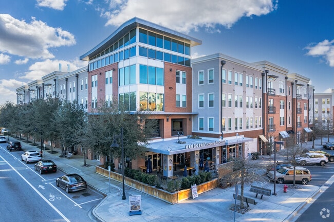
Property Record
725 Coleman Blvd, Mount Pleasant, SC 29464

Property Detail
725 Coleman Blvd
532-02-00-035
MAPPLATB L11 MAPPLATP 0302
Apartment
Charleston
B and X Area of moderate flood hazard, usually the area between the limits of the 100-year and 500-year floods.
South Carolina
2025
5.97 AC
2024
Mt Pleasant
004701
Charleston/N Charleston
31,094 SF
Charleston-North Charleston, SC
NEARBY LISTINGS FOR SALE OR LEASE
DEMOGRAPHICS near 725 Coleman Blvd
1 mile
3 mile
5 mile
2025 Total Population
9,780
36,357
98,671
2030 Population
10,239
37,794
103,691
Pop Growth 2025-2030
+ 4.69%
+ 3.95%
+ 5.09%
Average Age
41
42
40
2025 Total Households
4,299
16,026
43,710
HH Growth 2025-2030
+ 4.79%
+ 4.08%
+ 5.35%
Median Household Inc
$115,827
$113,997
$105,330
Avg Household Size
2.20
2.20
2.20
2025 Avg HH Vehicles
2.00
2.00
2.00
Median Home Value
$843,578
$848,250
$820,121
Median Year Built
1979
1988
1987
Nearby Places
Map Layers
Map Styles
 Street
 Aerial
Layers
 Traffic
 Biking
Places
Listings with unknown addresses are not visible on the map
- Restaurants
- Banks
- Shops
- Fitness
- Groceries
PUBLIC TRANSPORTATION
AIRPORT
Charleston AFB/International
Drive
Walk
Distance
Charleston AFB/International
28 min
17.7 mi
Freight Ports
Wando Welch Terminal
Drive
Walk
Distance
Wando Welch Terminal
9 min
5.2 mi
SALE & LEASE HISTORY
LISTING DATE
SALE/LEASE

Jul 16, 2024
For Lease
Feb 22, 2022
For Lease
Nearby Properties
Address
Land Use
TOTAL SIZE
Lot Size
Zoning
Address
Land Use
TOTAL SIZE
Lot Size
Zoning
247,883 SF
16.26 AC
Address
Land Use
TOTAL SIZE
Lot Size
Zoning
2,592 SF
13.64 AC
Address
Land Use
TOTAL SIZE
Lot Size
Zoning
Address
Land Use
TOTAL SIZE
Lot Size
Zoning
39,150 SF
7.76 AC
Address
Land Use
TOTAL SIZE
Lot Size
Zoning
Address
Land Use
TOTAL SIZE
Lot Size
Zoning
85,408 SF
9.39 AC
Address
Land Use
TOTAL SIZE
Lot Size
Zoning
Address
Land Use
TOTAL SIZE
Lot Size
Zoning
1,282 SF
8.42 AC
Address
Land Use
TOTAL SIZE
Lot Size
Zoning
12,358 SF
15.08 AC
Address
Land Use
TOTAL SIZE
Lot Size
Zoning
34,713 SF
13.51 AC
Address
Land Use
TOTAL SIZE
Lot Size
Zoning
Address
Land Use
TOTAL SIZE
Lot Size
Zoning
1,222 SF
13.62 AC
Address
Land Use
TOTAL SIZE
Lot Size
Zoning
37,472 SF
9.04 AC
Address
Land Use
TOTAL SIZE
Lot Size
Zoning
1,872 SF
4.48 AC
Address
Land Use
TOTAL SIZE
Lot Size
Zoning
1,064 SF
20.39 AC
Address
Land Use
TOTAL SIZE
Lot Size
Zoning
1,615 SF
32.59 AC
Address
Land Use
TOTAL SIZE
Lot Size
Zoning
11.29 AC
Address
Land Use
TOTAL SIZE
Lot Size
Zoning
10,165 SF
1.38 AC
Address
Land Use
TOTAL SIZE
Lot Size
Zoning
1,065 SF
1.01 AC
Address
Land Use
TOTAL SIZE
Lot Size
Zoning
Address
Land Use
TOTAL SIZE
Lot Size
Zoning
120,719 SF
7.14 AC
Address
Land Use
TOTAL SIZE
Lot Size
Zoning
648 SF
19.68 AC
Address
Land Use
TOTAL SIZE
Lot Size
Zoning
2.32 AC
Address
Land Use
TOTAL SIZE
Lot Size
Zoning
80,395 SF
15.24 AC
Address
Land Use
TOTAL SIZE
Lot Size
Zoning
2,624 SF
2 AC
Address
Land Use
TOTAL SIZE
Lot Size
Zoning
65,904 SF
3.87 AC
Address
Land Use
TOTAL SIZE
Lot Size
Zoning
5,884 SF
6.56 AC
Address
Land Use
TOTAL SIZE
Lot Size
Zoning
5,884 SF
8.02 AC
Address
Land Use
TOTAL SIZE
Lot Size
Zoning
10.05 AC
The World's #1 Commercial Real Estate Marketplace
Connect with us
© 2026 CoStar Group
The information above has been obtained from sources believed reliable. While we do not doubt its accuracy we have not verified it and make no guarantee, warranty or representation about it. It is your responsibility to independently confirm its accuracy and completeness. Any projections, opinions, assumptions, or estimates used are for example only and do not represent the current or future performance of the property. The value of this transaction to you depends on tax and other factors which should be evaluated by your tax, financial, and legal advisors. You and your advisors should conduct a careful, independent investigation of the property to determine to your satisfaction the suitability of the property for your needs.