Property Record
725 E 65Th St, Indianapolis, IN 46220
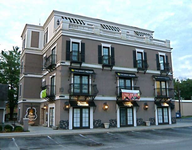

This Property Is For Sale
Property Detail
725 E 65Th St
Indianapolis-Carmel-Greenwood, IN
LIGHTS BROAD RIPPLE SUB L45
49-03-36-100-020.000-801
Marion
Officebuilding
Indiana
ZO01
45
2024
0.17 AC
2025
Uptown
320700
Indianapolis
9,498 SF
NEARBY LISTINGS FOR SALE OR LEASE
DEMOGRAPHICS near 725 E 65Th St
1 mile
3 mile
5 mile
2025 Total Population
9,670
78,636
219,198
2030 Population
9,755
79,255
222,821
Pop Growth 2025-2030
+ 0.88%
+ 0.79%
+ 1.65%
Average Age
39
39
39
2025 Total Households
4,973
34,962
96,540
HH Growth 2025-2030
+ 0.84%
+ 0.70%
+ 1.59%
Median Household Inc
$123,870
$93,994
$74,432
Avg Household Size
1.90
2.10
2.20
2025 Avg HH Vehicles
2.00
2.00
2.00
Median Home Value
$395,033
$351,260
$312,507
Median Year Built
1953
1959
1966
Nearby Places
Map Layers
Map Styles
 Street
 Aerial
Layers
 Traffic
 Biking
Places
Listings with unknown addresses are not visible on the map
- Restaurants
- Banks
- Shops
- Fitness
- Groceries
PUBLIC TRANSPORTATION
AIRPORT
Indianapolis International
Drive
Walk
Distance
Indianapolis International
40 min
21.3 mi
Nearby Properties
Address
Land Use
TOTAL SIZE
Lot Size
Zoning
Address
Land Use
TOTAL SIZE
Lot Size
Zoning
4,146 SF
45.91 AC
ZO01
Address
Land Use
TOTAL SIZE
Lot Size
Zoning
8,157 SF
113.93 AC
ZO01
Address
Land Use
TOTAL SIZE
Lot Size
Zoning
2,544 SF
37.75 AC
ZO01
Address
Land Use
TOTAL SIZE
Lot Size
Zoning
50,698 SF
13.58 AC
Address
Land Use
TOTAL SIZE
Lot Size
Zoning
76,657 SF
8.85 AC
ZO01
Address
Land Use
TOTAL SIZE
Lot Size
Zoning
207,800 SF
2.23 AC
ZO01
Address
Land Use
TOTAL SIZE
Lot Size
Zoning
272,688 SF
14.60 AC
ZO01
Address
Land Use
TOTAL SIZE
Lot Size
Zoning
5,685 SF
5.53 AC
ZO01
Address
Land Use
TOTAL SIZE
Lot Size
Zoning
25,340 SF
8.57 AC
ZO01
Address
Land Use
TOTAL SIZE
Lot Size
Zoning
6,306 SF
33.65 AC
ZO01
Address
Land Use
TOTAL SIZE
Lot Size
Zoning
23,195 SF
31.18 AC
Address
Land Use
TOTAL SIZE
Lot Size
Zoning
13,789 SF
3.93 AC
ZO01
Address
Land Use
TOTAL SIZE
Lot Size
Zoning
2,156 SF
0.46 AC
ZO01
Address
Land Use
TOTAL SIZE
Lot Size
Zoning
2,313 SF
35.45 AC
ZO01
Address
Land Use
TOTAL SIZE
Lot Size
Zoning
14,854 SF
14.07 AC
ZO01
Address
Land Use
TOTAL SIZE
Lot Size
Zoning
29,662 SF
17.96 AC
ZO01
Address
Land Use
TOTAL SIZE
Lot Size
Zoning
98,790 SF
0.18 AC
ZO01
Address
Land Use
TOTAL SIZE
Lot Size
Zoning
147,824 SF
11.39 AC
ZO01
Address
Land Use
TOTAL SIZE
Lot Size
Zoning
170,049 SF
12.74 AC
ZO01
Address
Land Use
TOTAL SIZE
Lot Size
Zoning
1,080 SF
19.24 AC
Address
Land Use
TOTAL SIZE
Lot Size
Zoning
5,670 SF
25.69 AC
Address
Land Use
TOTAL SIZE
Lot Size
Zoning
9,930 SF
9.10 AC
ZO01
Address
Land Use
TOTAL SIZE
Lot Size
Zoning
33,127 SF
11.51 AC
ZO01
Address
Land Use
TOTAL SIZE
Lot Size
Zoning
2.81 AC
ZO01
Address
Land Use
TOTAL SIZE
Lot Size
Zoning
7,740 SF
2.04 AC
ZO01
Address
Land Use
TOTAL SIZE
Lot Size
Zoning
81,511 SF
13.55 AC
Address
Land Use
TOTAL SIZE
Lot Size
Zoning
1,903 SF
20.77 AC
ZO01
Address
Land Use
TOTAL SIZE
Lot Size
Zoning
1,528 SF
15.64 AC
ZO01
Address
Land Use
TOTAL SIZE
Lot Size
Zoning
98,160 SF
0.65 AC
ZO01
Address
Land Use
TOTAL SIZE
Lot Size
Zoning
17,621 SF
3.20 AC
ZO01
The World's #1 Commercial Real Estate Marketplace
Connect with us
© 2026 CoStar Group
The information above has been obtained from sources believed reliable. While we do not doubt its accuracy we have not verified it and make no guarantee, warranty or representation about it. It is your responsibility to independently confirm its accuracy and completeness. Any projections, opinions, assumptions, or estimates used are for example only and do not represent the current or future performance of the property. The value of this transaction to you depends on tax and other factors which should be evaluated by your tax, financial, and legal advisors. You and your advisors should conduct a careful, independent investigation of the property to determine to your satisfaction the suitability of the property for your needs.