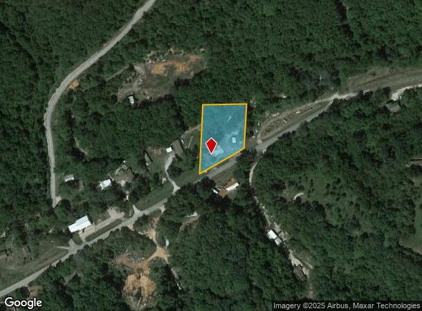
Property Record
725 State Highway 248, Reeds Spring, MO 65737

NEARBY LISTINGS FOR SALE OR LEASE
Property Detail
725 State Highway 248
Commercialnec
BEG AT PT WHERE N R/W OF HWY INTERSECTS E LINE OF NE NW, N 200, W 200, S TO N R/W, NE ALONG R/W TO POB
A
Stone
29209C0150D
Missouri
2024
1.20 AC
2025
Branson
090606
Other Market Areas
3,062 SF
08-7.0-25-000-000-007.000
DEMOGRAPHICS near 725 State Highway 248
1 Mile
3 Mile
5 Mile
2024 Total Population
379
2,407
4,594
2029 Population
404
2,570
4,900
Pop Growth 2024-2029
+ 6.60%
+ 6.77%
+ 6.66%
Average Age
41
42
42
2024 Total Households
147
939
1,774
HH Growth 2024-2029
+ 5.44%
+ 5.96%
+ 5.98%
Median Household Inc
$33,958
$42,410
$50,969
Avg Household Size
2.50
2.50
2.50
2024 Avg HH Vehicles
2.00
2.00
2.00
Median Home Value
$127,907
$160,306
$184,936
Median Year Built
1986
1989
1991
Nearby Places
Map Layers
Map Styles
 Street
 Aerial
- Restaurants
- Banks
- Shops
- Fitness
- Groceries
PUBLIC TRANSPORTATION
AIRPORT
Springfield-Branson Ntl
DRIVE
WALK
Distance
Springfield-Branson Ntl
68 min
43.1 mi
SALE & LEASE HISTORY
LISTING DATE
SALE/LEASE

Mar 14, 2017
For Sale
Dec 21, 2018
For Sale
Nearby Properties
Address
Land Use
TOTAL SIZE
Lot Size
Zoning
Address
Land Use
TOTAL SIZE
Lot Size
Zoning
108,452 SF
47.84 AC
A-1
Address
Land Use
TOTAL SIZE
Lot Size
Zoning
74,763 SF
28.27 AC
NA
Address
Land Use
TOTAL SIZE
Lot Size
Zoning
15,000 SF
2.32 AC
NA
Address
Land Use
TOTAL SIZE
Lot Size
Zoning
93,998 SF
39 AC
NA
Address
Land Use
TOTAL SIZE
Lot Size
Zoning
8,100 SF
1.13 AC
Address
Land Use
TOTAL SIZE
Lot Size
Zoning
9,064 SF
1.40 AC
RR-1
Address
Land Use
TOTAL SIZE
Lot Size
Zoning
8,964 SF
1.76 AC
NA
Address
Land Use
TOTAL SIZE
Lot Size
Zoning
15,039 SF
2 AC
NA
Address
Land Use
TOTAL SIZE
Lot Size
Zoning
12,338 SF
7.81 AC
C-2
Address
Land Use
TOTAL SIZE
Lot Size
Zoning
6,634 SF
24.06 AC
NA
Address
Land Use
TOTAL SIZE
Lot Size
Zoning
43,104 SF
5.86 AC
C-2
Address
Land Use
TOTAL SIZE
Lot Size
Zoning
22,500 SF
12.15 AC
NA
Address
Land Use
TOTAL SIZE
Lot Size
Zoning
3,321 SF
2.60 AC
R-1
Address
Land Use
TOTAL SIZE
Lot Size
Zoning
11,633 SF
13.80 AC
C-2
Address
Land Use
TOTAL SIZE
Lot Size
Zoning
3,192 SF
3.50 AC
C-2
Address
Land Use
TOTAL SIZE
Lot Size
Zoning
1,600 SF
6.60 AC
A-1
Address
Land Use
TOTAL SIZE
Lot Size
Zoning
18,200 SF
2.04 AC
NA
Address
Land Use
TOTAL SIZE
Lot Size
Zoning
29,468 SF
15.36 AC
NA
Address
Land Use
TOTAL SIZE
Lot Size
Zoning
3,600 SF
3.50 AC
A-1
Address
Land Use
TOTAL SIZE
Lot Size
Zoning
3,600 SF
0.26 AC
NA
Address
Land Use
TOTAL SIZE
Lot Size
Zoning
11,520 SF
1.60 AC
NA
Address
Land Use
TOTAL SIZE
Lot Size
Zoning
2,394 SF
0.69 AC
NA
Address
Land Use
TOTAL SIZE
Lot Size
Zoning
25,192 SF
5.33 AC
C-2
Address
Land Use
TOTAL SIZE
Lot Size
Zoning
1,812 SF
1.37 AC
RR-1
Address
Land Use
TOTAL SIZE
Lot Size
Zoning
14,934 SF
8.88 AC
C-2
Address
Land Use
TOTAL SIZE
Lot Size
Zoning
3,989 SF
1.10 AC
NA
Address
Land Use
TOTAL SIZE
Lot Size
Zoning
15,340 SF
2.90 AC
C-2
Address
Land Use
TOTAL SIZE
Lot Size
Zoning
9,968 SF
1.50 AC
C-2
Address
Land Use
TOTAL SIZE
Lot Size
Zoning
2,401 SF
3.03 AC
C-2
The World's #1 Commercial Real Estate Marketplace
Connect with us
© 2026 CoStar Group
The information above has been obtained from sources believed reliable. While we do not doubt its accuracy we have not verified it and make no guarantee, warranty or representation about it. It is your responsibility to independently confirm its accuracy and completeness. Any projections, opinions, assumptions, or estimates used are for example only and do not represent the current or future performance of the property. The value of this transaction to you depends on tax and other factors which should be evaluated by your tax, financial, and legal advisors. You and your advisors should conduct a careful, independent investigation of the property to determine to your satisfaction the suitability of the property for your needs.