Property Record
715 E Memorial Rd, Oklahoma City, OK 73114

Save to a Folder
{{folder.Name}}
{{folder.ListingIds.length}} Properties
{{folder.ListingIds.length}} Property
Create a New Folder
Property Detail
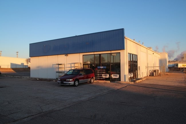
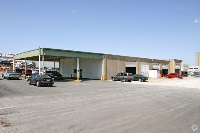
715 E Memorial Rd
144013050
UNPLTD PT SEC 10 13N 3W 000 000 PT SE4 SEC 10 13N 3W BEG 616.18FT E OF SW/C SE4 TH N420.40FT E249.50FT S200.40FT E260FT S220FT W509.50FT TO BEG CONT 3.72ACRS MORE OR LESS SUBJ TO ESMTS OF RECORD
Storebuilding
Oklahoma
I-2
Oklahoma
B and X Area of moderate flood hazard, usually the area between the limits of the 100-year and 500-year floods.
4.24 AC
2024
North
2025
Oklahoma City
108318
Oklahoma City, OK
7,470 SF
NEARBY LISTINGS FOR SALE OR LEASE
DEMOGRAPHICS near 715 E Memorial Rd
1 mile
3 mile
5 mile
2025 Total Population
1,373
62,520
174,917
2030 Population
1,373
63,692
178,135
Pop Growth 2025-2030
0.00%
+ 1.87%
+ 1.84%
Average Age
35
37
38
2025 Total Households
594
26,700
72,913
HH Growth 2025-2030
0.00%
+ 2.22%
+ 2.08%
Median Household Inc
$64,125
$73,332
$80,256
Avg Household Size
2.30
2.20
2.30
2025 Avg HH Vehicles
2.00
2.00
2.00
Median Home Value
$168,247
$264,063
$289,076
Median Year Built
1987
1989
1987
Nearby Places
Map Layers
Map Styles
 Street
 Aerial
Layers
 Traffic
 Biking
Places
Listings with unknown addresses are not visible on the map
- Restaurants
- Banks
- Shops
- Fitness
- Groceries
PUBLIC TRANSPORTATION
AIRPORT
Will Rogers World
Drive
Walk
Distance
Will Rogers World
33 min
19.8 mi
Freight Ports
Tulsa Port Of Catoosa
Drive
Walk
Distance
Tulsa Port Of Catoosa
127 min
117.5 mi
Nearby Properties
Address
Land Use
TOTAL SIZE
Lot Size
Zoning
Address
Land Use
TOTAL SIZE
Lot Size
Zoning
242,907 SF
I-2
Address
Land Use
TOTAL SIZE
Lot Size
Zoning
233,053 SF
18.93 AC
O-2
Address
Land Use
TOTAL SIZE
Lot Size
Zoning
460,954 SF
24.83 AC
PUD
Address
Land Use
TOTAL SIZE
Lot Size
Zoning
469,063 SF
71.44 AC
I-2
Address
Land Use
TOTAL SIZE
Lot Size
Zoning
268,796 SF
45.68 AC
I-2
Address
Land Use
TOTAL SIZE
Lot Size
Zoning
304,423 SF
31.20 AC
PUD
Address
Land Use
TOTAL SIZE
Lot Size
Zoning
7.42 AC
PUD
Address
Land Use
TOTAL SIZE
Lot Size
Zoning
391,776 SF
10.12 AC
PUD
Address
Land Use
TOTAL SIZE
Lot Size
Zoning
399,688 SF
80.57 AC
PUD
Address
Land Use
TOTAL SIZE
Lot Size
Zoning
285,136 SF
13.04 AC
PUD
Address
Land Use
TOTAL SIZE
Lot Size
Zoning
470,139 SF
80.39 AC
I-2
Address
Land Use
TOTAL SIZE
Lot Size
Zoning
105,426 SF
7.79 AC
O-2
Address
Land Use
TOTAL SIZE
Lot Size
Zoning
158,078 SF
15.58 AC
PUD
Address
Land Use
TOTAL SIZE
Lot Size
Zoning
12,633 SF
2 AC
C-3
Address
Land Use
TOTAL SIZE
Lot Size
Zoning
225,492 SF
11.86 AC
R-4
Address
Land Use
TOTAL SIZE
Lot Size
Zoning
13,101 SF
1.22 AC
PUD
Address
Land Use
TOTAL SIZE
Lot Size
Zoning
43,489 SF
14.86 AC
PUD
Address
Land Use
TOTAL SIZE
Lot Size
Zoning
140,153 SF
13.07 AC
PUD
Address
Land Use
TOTAL SIZE
Lot Size
Zoning
333,902 SF
19.32 AC
PUD
Address
Land Use
TOTAL SIZE
Lot Size
Zoning
574,062 SF
53.69 AC
I-2
Address
Land Use
TOTAL SIZE
Lot Size
Zoning
242,196 SF
14.07 AC
Address
Land Use
TOTAL SIZE
Lot Size
Zoning
265,194 SF
13.67 AC
Address
Land Use
TOTAL SIZE
Lot Size
Zoning
234,208 SF
8.61 AC
PUD
Address
Land Use
TOTAL SIZE
Lot Size
Zoning
102,304 SF
9.89 AC
PUD
Address
Land Use
TOTAL SIZE
Lot Size
Zoning
221,364 SF
12.09 AC
Address
Land Use
TOTAL SIZE
Lot Size
Zoning
200,836 SF
10.79 AC
R-4
Address
Land Use
TOTAL SIZE
Lot Size
Zoning
138,774 SF
14.63 AC
Address
Land Use
TOTAL SIZE
Lot Size
Zoning
Address
Land Use
TOTAL SIZE
Lot Size
Zoning
82,162 SF
6.13 AC
Address
Land Use
TOTAL SIZE
Lot Size
Zoning
160,416 SF
4.85 AC
PUD
The World's #1 Commercial Real Estate Marketplace
Connect with us
© 2026 CoStar Group
The information above has been obtained from sources believed reliable. While we do not doubt its accuracy we have not verified it and make no guarantee, warranty or representation about it. It is your responsibility to independently confirm its accuracy and completeness. Any projections, opinions, assumptions, or estimates used are for example only and do not represent the current or future performance of the property. The value of this transaction to you depends on tax and other factors which should be evaluated by your tax, financial, and legal advisors. You and your advisors should conduct a careful, independent investigation of the property to determine to your satisfaction the suitability of the property for your needs.