Property Record
725 Highway 53, Clearlake, CA 95422
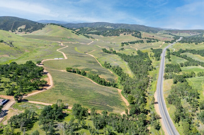
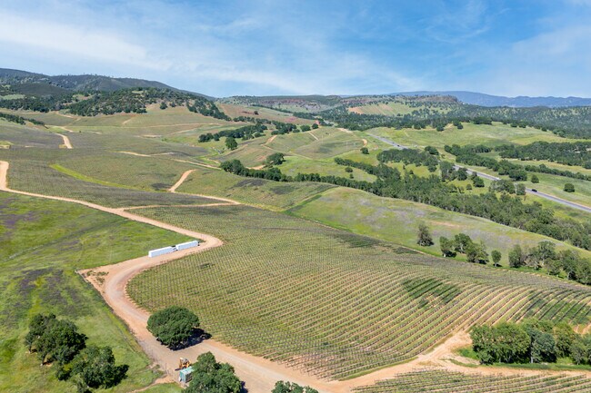
Property Detail
725 Highway 53
010-055-200-000
LAKE
Pasture
California
RR
58.94 AC
B and X Area of moderate flood hazard, usually the area between the limits of the 100-year and 500-year floods.
California North Rural Area
2025
Other Market Areas
2025
Clearlake, CA
000802
NEARBY LISTINGS FOR SALE OR LEASE
DEMOGRAPHICS near 725 Highway 53
1 mile
3 mile
5 mile
2025 Total Population
15
6,387
18,653
2030 Population
14
6,165
18,024
Pop Growth 2025-2030
(6.67%)
(3.48%)
(3.37%)
Average Age
39
41
41
2025 Total Households
6
2,527
7,423
HH Growth 2025-2030
0.00%
(3.48%)
(3.45%)
Median Household Inc
$37,500
$34,411
$40,414
Avg Household Size
1.70
2.40
2.50
2025 Avg HH Vehicles
2.00
2.00
2.00
Median Home Value
$150,000
$196,861
$231,847
Median Year Built
1979
1976
1975
Nearby Places
Map Layers
Map Styles
 Street
 Aerial
Transit
 Traffic
 Biking
Places
Listings with unknown addresses are not visible on the map
- Restaurants
- Banks
- Shops
- Fitness
- Groceries
SALE & LEASE HISTORY
LISTING DATE
SALE/LEASE

May 23, 2025
For Sale
Nearby Properties
Address
Land Use
TOTAL SIZE
Lot Size
Zoning
Address
Land Use
TOTAL SIZE
Lot Size
Zoning
Address
Land Use
TOTAL SIZE
Lot Size
Zoning
36,280 SF
3.32 AC
Address
Land Use
TOTAL SIZE
Lot Size
Zoning
598.02 AC
RL
Address
Land Use
TOTAL SIZE
Lot Size
Zoning
17,272 SF
2.05 AC
Address
Land Use
TOTAL SIZE
Lot Size
Zoning
5,538 SF
5.58 AC
Address
Land Use
TOTAL SIZE
Lot Size
Zoning
962 SF
1.50 AC
Address
Land Use
TOTAL SIZE
Lot Size
Zoning
6,344 SF
0.59 AC
Address
Land Use
TOTAL SIZE
Lot Size
Zoning
247.98 AC
PDC
Address
Land Use
TOTAL SIZE
Lot Size
Zoning
67.30 AC
RL
Address
Land Use
TOTAL SIZE
Lot Size
Zoning
32,852 SF
3.33 AC
Address
Land Use
TOTAL SIZE
Lot Size
Zoning
1,454 SF
120.31 AC
APZ
Address
Land Use
TOTAL SIZE
Lot Size
Zoning
87.36 AC
RL
Address
Land Use
TOTAL SIZE
Lot Size
Zoning
65.93 AC
RR
Address
Land Use
TOTAL SIZE
Lot Size
Zoning
78.61 AC
RL
Address
Land Use
TOTAL SIZE
Lot Size
Zoning
6,652 SF
3.04 AC
Address
Land Use
TOTAL SIZE
Lot Size
Zoning
155.09 AC
RL
Address
Land Use
TOTAL SIZE
Lot Size
Zoning
2,265 SF
79.65 AC
APZ
Address
Land Use
TOTAL SIZE
Lot Size
Zoning
155.59 AC
RL
Address
Land Use
TOTAL SIZE
Lot Size
Zoning
3,705 SF
0.98 AC
Address
Land Use
TOTAL SIZE
Lot Size
Zoning
30,440 SF
3.33 AC
Address
Land Use
TOTAL SIZE
Lot Size
Zoning
3.90 AC
Address
Land Use
TOTAL SIZE
Lot Size
Zoning
45.76 AC
RR
Address
Land Use
TOTAL SIZE
Lot Size
Zoning
3,280 SF
0.43 AC
Address
Land Use
TOTAL SIZE
Lot Size
Zoning
3.58 AC
Address
Land Use
TOTAL SIZE
Lot Size
Zoning
39.40 AC
RL
Address
Land Use
TOTAL SIZE
Lot Size
Zoning
4,800 SF
64.20 AC
Address
Land Use
TOTAL SIZE
Lot Size
Zoning
1.31 AC
Address
Land Use
TOTAL SIZE
Lot Size
Zoning
39.98 AC
RL
Address
Land Use
TOTAL SIZE
Lot Size
Zoning
The World's #1 Commercial Real Estate Marketplace
Connect with us
© 2026 CoStar Group
The information above has been obtained from sources believed reliable. While we do not doubt its accuracy we have not verified it and make no guarantee, warranty or representation about it. It is your responsibility to independently confirm its accuracy and completeness. Any projections, opinions, assumptions, or estimates used are for example only and do not represent the current or future performance of the property. The value of this transaction to you depends on tax and other factors which should be evaluated by your tax, financial, and legal advisors. You and your advisors should conduct a careful, independent investigation of the property to determine to your satisfaction the suitability of the property for your needs.