Property Record
725 Highway 96, Bonaire, GA 31005
NEARBY LISTINGS FOR SALE OR LEASE
-
-
-
-
-
HWY 96 and Peach Blossom @ Peach Blossom Road
Bonaire, GA 31005
Rent Upon Request
10.06 AC Lots
Land
-
-
-
View all Bonaire listings for sale on LoopNet.com
Property Detail
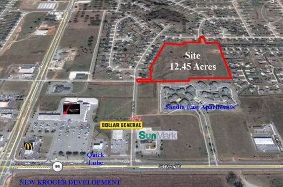
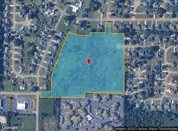
725 Highway 96
Warner Robins, GA
Ho Lk Hwy 96 30
0W0980159000
TRACT AA 12.45 ACRES 189/10TH
Residentialacreage
Houston
X
Georgia
13225C0150C
189
2024
12.45 AC
2024
Perry/Warner Robins
021108
Other Market Areas
DEMOGRAPHICS near 725 Highway 96
1 Mile
3 Mile
5 Mile
2024 Total Population
7,345
47,141
107,350
2029 Population
7,973
51,371
117,730
Pop Growth 2024-2029
+ 8.55%
+ 8.97%
+ 9.67%
Average Age
36
37
37
2024 Total Households
2,766
17,959
40,626
HH Growth 2024-2029
+ 8.28%
+ 8.83%
+ 9.45%
Median Household Inc
$86,174
$90,668
$81,986
Avg Household Size
2.60
2.60
2.60
2024 Avg HH Vehicles
2.00
2.00
2.00
Median Home Value
$175,210
$179,043
$181,703
Median Year Built
1999
1996
1995
Nearby Places
Map Layers
Map Styles
 Street
 Aerial
- Restaurants
- Banks
- Shops
- Fitness
- Groceries
SALE & LEASE HISTORY
LISTING DATE
SALE/LEASE

Sep 24, 2016
For Sale
Mar 31, 2017
For Sale
Nearby Properties
Address
Land Use
TOTAL SIZE
Lot Size
Zoning
Address
Land Use
TOTAL SIZE
Lot Size
Zoning
80,000 SF
46.13 AC
R2
Address
Land Use
TOTAL SIZE
Lot Size
Zoning
15,006 SF
30.30 AC
R4
Address
Land Use
TOTAL SIZE
Lot Size
Zoning
5,400 SF
22.93 AC
R4
Address
Land Use
TOTAL SIZE
Lot Size
Zoning
9,828 SF
18.63 AC
R4
Address
Land Use
TOTAL SIZE
Lot Size
Zoning
5,440 SF
36.50 AC
R4
Address
Land Use
TOTAL SIZE
Lot Size
Zoning
10,568 SF
35.44 AC
R4
Address
Land Use
TOTAL SIZE
Lot Size
Zoning
100,320 SF
26.91 AC
C2
Address
Land Use
TOTAL SIZE
Lot Size
Zoning
26,271 SF
17.43 AC
C2
Address
Land Use
TOTAL SIZE
Lot Size
Zoning
273,000 SF
63.42 AC
C2
Address
Land Use
TOTAL SIZE
Lot Size
Zoning
219,205 SF
26.17 AC
R2
Address
Land Use
TOTAL SIZE
Lot Size
Zoning
112,824 SF
13.07 AC
C2
Address
Land Use
TOTAL SIZE
Lot Size
Zoning
112,824 SF
Address
Land Use
TOTAL SIZE
Lot Size
Zoning
112,824 SF
Address
Land Use
TOTAL SIZE
Lot Size
Zoning
28,668 SF
17.38 AC
R4 C2
Address
Land Use
TOTAL SIZE
Lot Size
Zoning
16,570 SF
15.62 AC
R4
Address
Land Use
TOTAL SIZE
Lot Size
Zoning
67,732 SF
25 AC
R4
Address
Land Use
TOTAL SIZE
Lot Size
Zoning
134,400 SF
22.43 AC
R1
Address
Land Use
TOTAL SIZE
Lot Size
Zoning
76,751 SF
26.32 AC
R1
Address
Land Use
TOTAL SIZE
Lot Size
Zoning
19,200 SF
14.70 AC
R4
Address
Land Use
TOTAL SIZE
Lot Size
Zoning
122,858 SF
8.64 AC
C2
Address
Land Use
TOTAL SIZE
Lot Size
Zoning
156,000 SF
19.25 AC
R2
Address
Land Use
TOTAL SIZE
Lot Size
Zoning
17,832 SF
13.60 AC
R4
Address
Land Use
TOTAL SIZE
Lot Size
Zoning
100,500 SF
19.64 AC
R2
Address
Land Use
TOTAL SIZE
Lot Size
Zoning
78,956 SF
9.05 AC
C2
Address
Land Use
TOTAL SIZE
Lot Size
Zoning
100,500 SF
19.74 AC
R2
Address
Land Use
TOTAL SIZE
Lot Size
Zoning
39,810 SF
26.92 AC
C1
Address
Land Use
TOTAL SIZE
Lot Size
Zoning
38,112 SF
8.84 AC
R4
Address
Land Use
TOTAL SIZE
Lot Size
Zoning
6,624 SF
8.08 AC
R4
Address
Land Use
TOTAL SIZE
Lot Size
Zoning
6,574 SF
10.14 AC
R4
Address
Land Use
TOTAL SIZE
Lot Size
Zoning
85,580 SF
33.60 AC
R2
The World's #1 Commercial Real Estate Marketplace
Connect with us
© 2025 CoStar Group
The information above has been obtained from sources believed reliable. While we do not doubt its accuracy we have not verified it and make no guarantee, warranty or representation about it. It is your responsibility to independently confirm its accuracy and completeness. Any projections, opinions, assumptions, or estimates used are for example only and do not represent the current or future performance of the property. The value of this transaction to you depends on tax and other factors which should be evaluated by your tax, financial, and legal advisors. You and your advisors should conduct a careful, independent investigation of the property to determine to your satisfaction the suitability of the property for your needs.