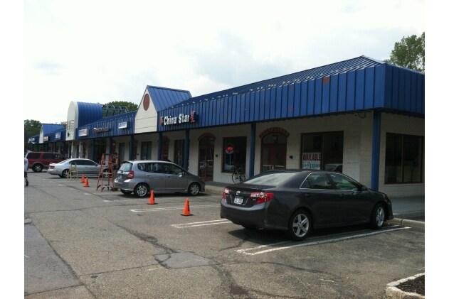
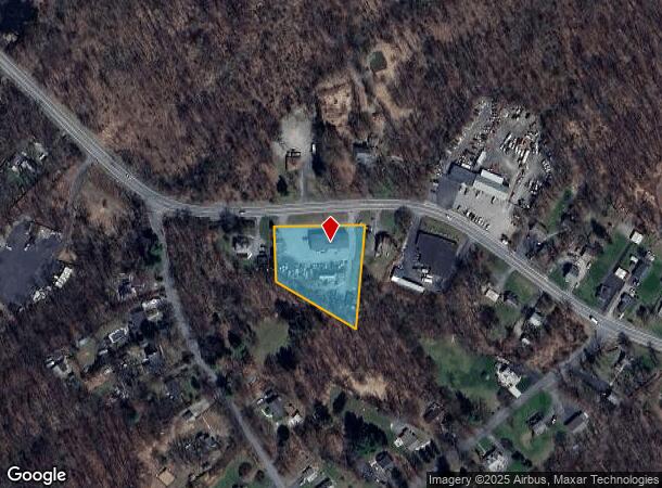
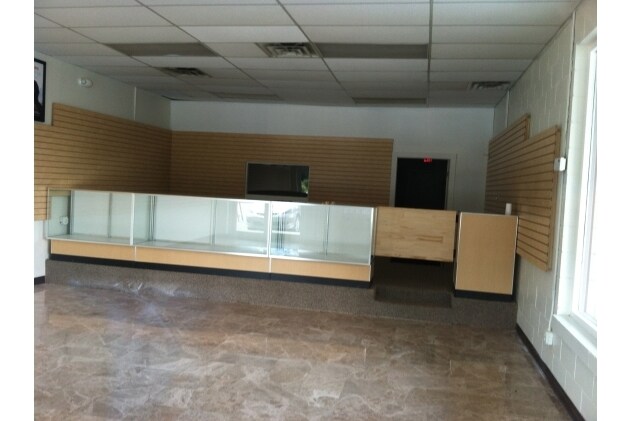
Property Record
725 Rte 211 W, T O Wallkill, NY 10940
NEARBY LISTINGS FOR SALE OR LEASE
Property Detail
725 Rte 211 W
New York-Jersey City-White Plains, NY-NJ
PARTIAL
335200-032-000-0002-005.000-0000
Orange
Warehouse
New York
X
5.000
36071C0255E
1.20 AC
2024
Middletown
2024
Northern New Jersey
011400
DEMOGRAPHICS near 725 Rte 211 W
1 Mile
3 Mile
5 Mile
2024 Total Population
898
22,900
61,659
2029 Population
895
23,262
62,764
Pop Growth 2024-2029
(0.33%)
+ 1.58%
+ 1.79%
Average Age
41
39
40
2024 Total Households
326
7,865
22,388
HH Growth 2024-2029
(0.31%)
+ 1.69%
+ 1.96%
Median Household Inc
$105,335
$80,224
$77,778
Avg Household Size
2.70
2.70
2.60
2024 Avg HH Vehicles
3.00
2.00
2.00
Median Home Value
$256,745
$265,647
$264,039
Median Year Built
1959
1959
1974
Nearby Places
Map Layers
Map Styles
 Street
 Aerial
- Restaurants
- Banks
- Shops
- Fitness
- Groceries
PUBLIC TRANSPORTATION
COMMUTER RAIL
Otisville (Bergen County/Port Jervis Line - NJ Transit Commuter Rail (NJ Transit), Main/Port Jervis Line - NJ Transit Commuter Rail (NJ Transit))
DRIVE
WALK
Distance
Otisville (Bergen County/Port Jervis Line - NJ Transit Commuter Rail (NJ Transit), Main/Port Jervis Line - NJ Transit Commuter Rail (NJ Transit))
6 min
4.2 mi
Middletown New York (Bergen County/Port Jervis Line - NJ Transit Commuter Rail (NJ Transit), Main/Port Jervis Line - NJ Transit Commuter Rail (NJ Transit))
DRIVE
WALK
Distance
Middletown New York (Bergen County/Port Jervis Line - NJ Transit Commuter Rail (NJ Transit), Main/Port Jervis Line - NJ Transit Commuter Rail (NJ Transit))
12 min
6.2 mi
AIRPORT
New York Stewart International
DRIVE
WALK
Distance
New York Stewart International
36 min
26.4 mi
Freight Ports
Port Newark Container Terminal
DRIVE
WALK
Distance
Port Newark Container Terminal
100 min
75.0 mi
Nearby Properties
Address
Land Use
TOTAL SIZE
Lot Size
Zoning
Address
Land Use
TOTAL SIZE
Lot Size
Zoning
Address
Land Use
TOTAL SIZE
Lot Size
Zoning
17.60 AC
R-1
Address
Land Use
TOTAL SIZE
Lot Size
Zoning
12.60 AC
R-1
Address
Land Use
TOTAL SIZE
Lot Size
Zoning
55,972 SF
0.85 AC
DN
Address
Land Use
TOTAL SIZE
Lot Size
Zoning
3.70 AC
R-1
Address
Land Use
TOTAL SIZE
Lot Size
Zoning
26,800 SF
3.50 AC
Address
Land Use
TOTAL SIZE
Lot Size
Zoning
11.10 AC
SR-3B
Address
Land Use
TOTAL SIZE
Lot Size
Zoning
9 AC
SR-3B
Address
Land Use
TOTAL SIZE
Lot Size
Zoning
71,338 SF
5.30 AC
ENT-L
Address
Land Use
TOTAL SIZE
Lot Size
Zoning
5 AC
I-1A
Address
Land Use
TOTAL SIZE
Lot Size
Zoning
2 AC
DMU
Address
Land Use
TOTAL SIZE
Lot Size
Zoning
2.20 AC
SR-3B
Address
Land Use
TOTAL SIZE
Lot Size
Zoning
11.20 AC
SR-3B
Address
Land Use
TOTAL SIZE
Lot Size
Zoning
0.95 AC
DMU
Address
Land Use
TOTAL SIZE
Lot Size
Zoning
4.50 AC
Address
Land Use
TOTAL SIZE
Lot Size
Zoning
3.80 AC
DMU
Address
Land Use
TOTAL SIZE
Lot Size
Zoning
15.70 AC
I-1A
Address
Land Use
TOTAL SIZE
Lot Size
Zoning
24,138 SF
15.40 AC
R1
Address
Land Use
TOTAL SIZE
Lot Size
Zoning
12,920 SF
31 AC
RA
Address
Land Use
TOTAL SIZE
Lot Size
Zoning
14.90 AC
OR-2
Address
Land Use
TOTAL SIZE
Lot Size
Zoning
69,660 SF
11.30 AC
TC
Address
Land Use
TOTAL SIZE
Lot Size
Zoning
24,138 SF
0.01 AC
R1
Address
Land Use
TOTAL SIZE
Lot Size
Zoning
11,012 SF
11.70 AC
O/R
Address
Land Use
TOTAL SIZE
Lot Size
Zoning
35.30 AC
Address
Land Use
TOTAL SIZE
Lot Size
Zoning
2.40 AC
SR-3B
Address
Land Use
TOTAL SIZE
Lot Size
Zoning
0.48 AC
DMU
Address
Land Use
TOTAL SIZE
Lot Size
Zoning
6.60 AC
I-3
Address
Land Use
TOTAL SIZE
Lot Size
Zoning
45.90 AC
R-1
Address
Land Use
TOTAL SIZE
Lot Size
Zoning
1.70 AC
I-1A
Address
Land Use
TOTAL SIZE
Lot Size
Zoning
1.60 AC
DMU
The World's #1 Commercial Real Estate Marketplace
Connect with us
© 2025 CoStar Group
The information above has been obtained from sources believed reliable. While we do not doubt its accuracy we have not verified it and make no guarantee, warranty or representation about it. It is your responsibility to independently confirm its accuracy and completeness. Any projections, opinions, assumptions, or estimates used are for example only and do not represent the current or future performance of the property. The value of this transaction to you depends on tax and other factors which should be evaluated by your tax, financial, and legal advisors. You and your advisors should conduct a careful, independent investigation of the property to determine to your satisfaction the suitability of the property for your needs.