Property Record
725 Sterlington Hwy, Farmerville, LA 71241


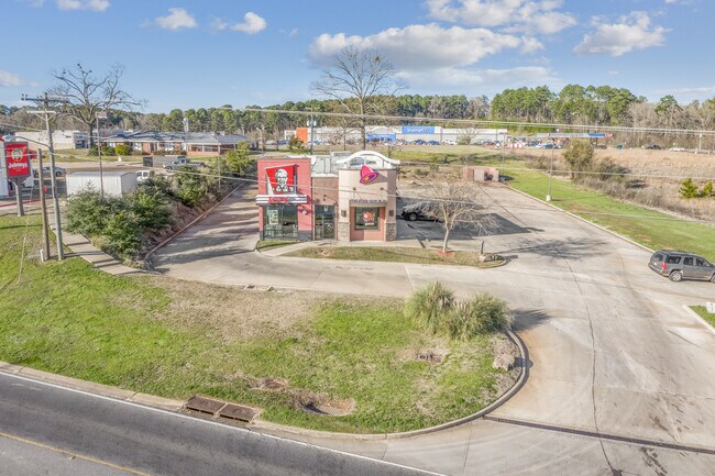
Property Detail
725 Sterlington Hwy
4507
BEGIN AT THE NWC OF SEC. 32, T21N R1E, RUN S. 89 DEG. 52 MIN. 05 SEC. E. FOR A DISTANCE OF 543.00 FT., S. 00 DEG. 02 MIN. 29
Commercialnec
UNION
B and X Area of moderate flood hazard, usually the area between the limits of the 100-year and 500-year floods.
Louisiana
2025
0.81 AC
2025
Louisiana North Area
960400
Other Market Areas
2,695 SF
Monroe, LA
NEARBY LISTINGS FOR SALE OR LEASE
DEMOGRAPHICS near 725 Sterlington Hwy
1 mile
3 mile
5 mile
2025 Total Population
1,596
4,292
6,774
2030 Population
1,566
4,218
6,654
Pop Growth 2025-2030
(1.88%)
(1.72%)
(1.77%)
Average Age
41
42
43
2025 Total Households
632
1,712
2,750
HH Growth 2025-2030
(1.90%)
(1.75%)
(1.75%)
Median Household Inc
$24,550
$28,370
$39,765
Avg Household Size
2.30
2.30
2.30
2025 Avg HH Vehicles
1.00
1.00
2.00
Median Home Value
$126,064
$145,593
$167,067
Median Year Built
1986
1987
1988
Nearby Places
Map Layers
Map Styles
 Street
 Aerial
Layers
 Traffic
 Biking
Places
Listings with unknown addresses are not visible on the map
- Restaurants
- Banks
- Shops
- Fitness
- Groceries
PUBLIC TRANSPORTATION
AIRPORT
Monroe Regional
Drive
Walk
Distance
Monroe Regional
53 min
35.8 mi
Freight Ports
Port of Shreveport
Drive
Walk
Distance
Port of Shreveport
129 min
102.8 mi
SALE & LEASE HISTORY
LISTING DATE
SALE/LEASE

Sep 30, 2020
For Lease
Sep 18, 2018
For Sale
Sep 18, 2018
For Sale
Feb 25, 2020
For Sale
Feb 07, 2019
For Sale
Aug 11, 2017
For Sale
Apr 10, 2019
For Sale
Apr 06, 2017
For Sale
Apr 04, 2017
For Sale
Nearby Properties
Address
Land Use
TOTAL SIZE
Lot Size
Zoning
Address
Land Use
TOTAL SIZE
Lot Size
Zoning
6,419 SF
40 AC
Address
Land Use
TOTAL SIZE
Lot Size
Zoning
173,320 SF
28 AC
Address
Land Use
TOTAL SIZE
Lot Size
Zoning
99,786 SF
18.58 AC
Address
Land Use
TOTAL SIZE
Lot Size
Zoning
32,330 SF
43 AC
Address
Land Use
TOTAL SIZE
Lot Size
Zoning
48,288 SF
5.46 AC
Address
Land Use
TOTAL SIZE
Lot Size
Zoning
37,212 SF
15.92 AC
Address
Land Use
TOTAL SIZE
Lot Size
Zoning
37,360 SF
27 AC
Address
Land Use
TOTAL SIZE
Lot Size
Zoning
45,578 SF
39 AC
Address
Land Use
TOTAL SIZE
Lot Size
Zoning
19,776 SF
5 AC
Address
Land Use
TOTAL SIZE
Lot Size
Zoning
8,078 SF
3.38 AC
Address
Land Use
TOTAL SIZE
Lot Size
Zoning
24,080 SF
3.85 AC
Address
Land Use
TOTAL SIZE
Lot Size
Zoning
13,335 SF
7 AC
Address
Land Use
TOTAL SIZE
Lot Size
Zoning
12,039 SF
1 AC
Address
Land Use
TOTAL SIZE
Lot Size
Zoning
11,840 SF
3.33 AC
Address
Land Use
TOTAL SIZE
Lot Size
Zoning
23,396 SF
2 AC
Address
Land Use
TOTAL SIZE
Lot Size
Zoning
8,597 SF
24 AC
Address
Land Use
TOTAL SIZE
Lot Size
Zoning
7,361 SF
10 AC
Address
Land Use
TOTAL SIZE
Lot Size
Zoning
Address
Land Use
TOTAL SIZE
Lot Size
Zoning
7,280 SF
9.72 AC
Address
Land Use
TOTAL SIZE
Lot Size
Zoning
6,714 SF
0.96 AC
Address
Land Use
TOTAL SIZE
Lot Size
Zoning
18,295 SF
9.09 AC
Address
Land Use
TOTAL SIZE
Lot Size
Zoning
11,252 SF
3 AC
Address
Land Use
TOTAL SIZE
Lot Size
Zoning
13,228 SF
60 AC
Address
Land Use
TOTAL SIZE
Lot Size
Zoning
10,320 SF
1 AC
Address
Land Use
TOTAL SIZE
Lot Size
Zoning
15,867 SF
0.64 AC
Address
Land Use
TOTAL SIZE
Lot Size
Zoning
Address
Land Use
TOTAL SIZE
Lot Size
Zoning
Address
Land Use
TOTAL SIZE
Lot Size
Zoning
10,579 SF
2 AC
Address
Land Use
TOTAL SIZE
Lot Size
Zoning
3,552 SF
The World's #1 Commercial Real Estate Marketplace
Connect with us
© 2026 CoStar Group
The information above has been obtained from sources believed reliable. While we do not doubt its accuracy we have not verified it and make no guarantee, warranty or representation about it. It is your responsibility to independently confirm its accuracy and completeness. Any projections, opinions, assumptions, or estimates used are for example only and do not represent the current or future performance of the property. The value of this transaction to you depends on tax and other factors which should be evaluated by your tax, financial, and legal advisors. You and your advisors should conduct a careful, independent investigation of the property to determine to your satisfaction the suitability of the property for your needs.