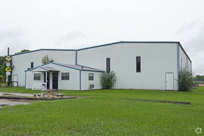
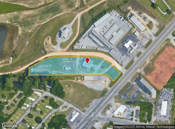
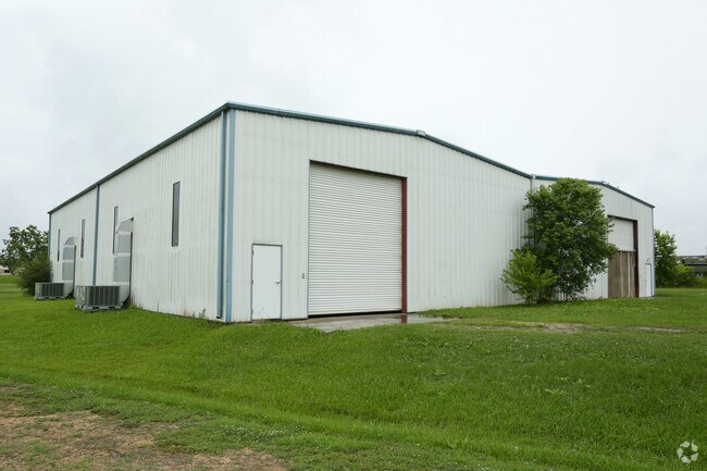
Property Record
725 Us Highway 231, Wetumpka, AL 36093
NEARBY LISTINGS FOR SALE OR LEASE
Property Detail
725 Us Highway 231
24-03-07-0-001-020002-0
BEG AT SW COR OF SE 1/4 OF SEC 7 T17N R19E; N 82.75'; NE 177.45'; NE 174.31'; E 424.97'; SW 209.99'; SE 149.89'; W 912.02' TO
Warehouse
Elmore
AE
Alabama
01101C0104J
4.36 AC
2025
Outlying Elmore County
2024
Montgomery
030701
Montgomery, AL
10,000 SF
DEMOGRAPHICS near 725 Us Highway 231
1 Mile
3 Mile
5 Mile
2024 Total Population
154
3,922
17,977
2029 Population
157
3,996
17,814
Pop Growth 2024-2029
+ 1.95%
+ 1.89%
(0.91%)
Average Age
45
45
39
2024 Total Households
59
1,504
6,708
HH Growth 2024-2029
+ 3.39%
+ 1.93%
(0.89%)
Median Household Inc
$84,375
$72,196
$69,689
Avg Household Size
2.50
2.40
2.50
2024 Avg HH Vehicles
2.00
2.00
2.00
Median Home Value
$265,217
$258,413
$175,780
Median Year Built
1990
1990
1989
Nearby Places
Map Layers
Map Styles
 Street
 Aerial
- Restaurants
- Banks
- Shops
- Fitness
- Groceries
PUBLIC TRANSPORTATION
AIRPORT
Montgomery Regional (Dannelly Field)
DRIVE
WALK
Distance
Montgomery Regional (Dannelly Field)
24 min
19.5 mi
Freight Ports
Port of Panama City
DRIVE
WALK
Distance
Port of Panama City
244 min
193.2 mi
SALE & LEASE HISTORY
LISTING DATE
SALE/LEASE

Jun 26, 2017
For Lease
Nearby Properties
Address
Land Use
TOTAL SIZE
Lot Size
Zoning
Address
Land Use
TOTAL SIZE
Lot Size
Zoning
48,672 SF
31 AC
Address
Land Use
TOTAL SIZE
Lot Size
Zoning
76,213 SF
15 AC
Address
Land Use
TOTAL SIZE
Lot Size
Zoning
11,297 SF
4.86 AC
Address
Land Use
TOTAL SIZE
Lot Size
Zoning
69,536 SF
7.81 AC
Address
Land Use
TOTAL SIZE
Lot Size
Zoning
27,436 SF
19 AC
AGR-2
Address
Land Use
TOTAL SIZE
Lot Size
Zoning
24,820 SF
3.68 AC
Address
Land Use
TOTAL SIZE
Lot Size
Zoning
7,990 SF
0.90 AC
Address
Land Use
TOTAL SIZE
Lot Size
Zoning
26,642 SF
5.10 AC
B-2
Address
Land Use
TOTAL SIZE
Lot Size
Zoning
30,646 SF
1.70 AC
B-3
Address
Land Use
TOTAL SIZE
Lot Size
Zoning
5,224 SF
1.36 AC
Address
Land Use
TOTAL SIZE
Lot Size
Zoning
15,863 SF
4.50 AC
Address
Land Use
TOTAL SIZE
Lot Size
Zoning
10,315 SF
1.70 AC
B-2
Address
Land Use
TOTAL SIZE
Lot Size
Zoning
10,772 SF
3.10 AC
Address
Land Use
TOTAL SIZE
Lot Size
Zoning
12,064 SF
2.79 AC
Address
Land Use
TOTAL SIZE
Lot Size
Zoning
21,206 SF
2.25 AC
B-3
Address
Land Use
TOTAL SIZE
Lot Size
Zoning
960 SF
327.50 AC
Address
Land Use
TOTAL SIZE
Lot Size
Zoning
494 SF
20 AC
AGR-2
Address
Land Use
TOTAL SIZE
Lot Size
Zoning
35,822 SF
6.83 AC
Address
Land Use
TOTAL SIZE
Lot Size
Zoning
3,420 SF
1.32 AC
Address
Land Use
TOTAL SIZE
Lot Size
Zoning
13,708 SF
5 AC
Address
Land Use
TOTAL SIZE
Lot Size
Zoning
5,094 SF
3.55 AC
Address
Land Use
TOTAL SIZE
Lot Size
Zoning
Address
Land Use
TOTAL SIZE
Lot Size
Zoning
2,070 SF
13.30 AC
B-2
Address
Land Use
TOTAL SIZE
Lot Size
Zoning
10,420 SF
7 AC
Address
Land Use
TOTAL SIZE
Lot Size
Zoning
1,200 SF
3.61 AC
Address
Land Use
TOTAL SIZE
Lot Size
Zoning
2,242 SF
1.26 AC
Address
Land Use
TOTAL SIZE
Lot Size
Zoning
11,106 SF
15 AC
B-2
Address
Land Use
TOTAL SIZE
Lot Size
Zoning
2,990 SF
1.54 AC
Address
Land Use
TOTAL SIZE
Lot Size
Zoning
424.70 AC
Address
Land Use
TOTAL SIZE
Lot Size
Zoning
11,890 SF
1.60 AC
AGR-2
The World's #1 Commercial Real Estate Marketplace
Connect with us
© 2026 CoStar Group
The information above has been obtained from sources believed reliable. While we do not doubt its accuracy we have not verified it and make no guarantee, warranty or representation about it. It is your responsibility to independently confirm its accuracy and completeness. Any projections, opinions, assumptions, or estimates used are for example only and do not represent the current or future performance of the property. The value of this transaction to you depends on tax and other factors which should be evaluated by your tax, financial, and legal advisors. You and your advisors should conduct a careful, independent investigation of the property to determine to your satisfaction the suitability of the property for your needs.