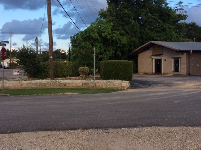
Property Record
725 W Plantation Dr, Clute, TX 77531

NEARBY LISTINGS FOR SALE OR LEASE
-
-
View all Clute listings for lease on LoopNet.com
Property Detail
725 W Plantation Dr
Houston-The Woodlands-Sugar Land, TX
Robertson (A0019 S F Austin Div 15 (B C
7325-0001-000
ROBERTSON (A0019 S F AUSTIN DIV 15 (B C I C) LOT 1-2
Commercialnec
Brazoria
X
Texas
48039C0620K
1-2
2024
0.32 AC
2025
Southwest Far
663900
Houston
5,184 SF
DEMOGRAPHICS near 725 W Plantation Dr
1 Mile
3 Mile
5 Mile
2024 Total Population
8,131
36,600
57,553
2029 Population
9,220
41,044
64,569
Pop Growth 2024-2029
+ 13.39%
+ 12.14%
+ 12.19%
Average Age
36
37
37
2024 Total Households
3,106
13,911
21,855
HH Growth 2024-2029
+ 13.75%
+ 12.52%
+ 12.50%
Median Household Inc
$66,944
$74,443
$71,784
Avg Household Size
2.60
2.60
2.60
2024 Avg HH Vehicles
2.00
2.00
2.00
Median Home Value
$151,963
$196,727
$203,395
Median Year Built
1983
1981
1983
Nearby Places
Map Layers
Map Styles
 Street
 Aerial
- Restaurants
- Banks
- Shops
- Fitness
- Groceries
SALE & LEASE HISTORY
LISTING DATE
SALE/LEASE

Sep 25, 2016
For Lease
Nearby Properties
Address
Land Use
TOTAL SIZE
Lot Size
Zoning
Address
Land Use
TOTAL SIZE
Lot Size
Zoning
35.50 AC
8680
Address
Land Use
TOTAL SIZE
Lot Size
Zoning
34.14 AC
Address
Land Use
TOTAL SIZE
Lot Size
Zoning
13.41 AC
Address
Land Use
TOTAL SIZE
Lot Size
Zoning
274,303 SF
15.11 AC
0004
Address
Land Use
TOTAL SIZE
Lot Size
Zoning
167,434 SF
25 AC
Address
Land Use
TOTAL SIZE
Lot Size
Zoning
98.38 AC
0182
Address
Land Use
TOTAL SIZE
Lot Size
Zoning
205,161 SF
9.47 AC
Address
Land Use
TOTAL SIZE
Lot Size
Zoning
123,012 SF
13.36 AC
Address
Land Use
TOTAL SIZE
Lot Size
Zoning
172,426 SF
74.07 AC
0146
Address
Land Use
TOTAL SIZE
Lot Size
Zoning
282,632 SF
32.94 AC
Address
Land Use
TOTAL SIZE
Lot Size
Zoning
90,104 SF
45.22 AC
0180
Address
Land Use
TOTAL SIZE
Lot Size
Zoning
161,170 SF
8.67 AC
Address
Land Use
TOTAL SIZE
Lot Size
Zoning
253,058 SF
12.07 AC
Address
Land Use
TOTAL SIZE
Lot Size
Zoning
102,425 SF
15.42 AC
Address
Land Use
TOTAL SIZE
Lot Size
Zoning
200,113 SF
10.07 AC
0033
Address
Land Use
TOTAL SIZE
Lot Size
Zoning
94,891 SF
13.94 AC
Address
Land Use
TOTAL SIZE
Lot Size
Zoning
200,711 SF
9.88 AC
0041
Address
Land Use
TOTAL SIZE
Lot Size
Zoning
70,468 SF
15.84 AC
0146A
Address
Land Use
TOTAL SIZE
Lot Size
Zoning
198,870 SF
10.09 AC
Address
Land Use
TOTAL SIZE
Lot Size
Zoning
145,222 SF
7.25 AC
0109
Address
Land Use
TOTAL SIZE
Lot Size
Zoning
216,802 SF
11.49 AC
Address
Land Use
TOTAL SIZE
Lot Size
Zoning
45,667 SF
66.18 AC
8500
Address
Land Use
TOTAL SIZE
Lot Size
Zoning
86,188 SF
14.39 AC
Address
Land Use
TOTAL SIZE
Lot Size
Zoning
67,565 SF
6.23 AC
Address
Land Use
TOTAL SIZE
Lot Size
Zoning
75.99 AC
0410
Address
Land Use
TOTAL SIZE
Lot Size
Zoning
120,591 SF
7.70 AC
Address
Land Use
TOTAL SIZE
Lot Size
Zoning
197,319 SF
9.94 AC
Address
Land Use
TOTAL SIZE
Lot Size
Zoning
136,550 SF
8.97 AC
Address
Land Use
TOTAL SIZE
Lot Size
Zoning
164,368 SF
6.85 AC
Address
Land Use
TOTAL SIZE
Lot Size
Zoning
184,398 SF
11.89 AC
The World's #1 Commercial Real Estate Marketplace
Connect with us
© 2026 CoStar Group
The information above has been obtained from sources believed reliable. While we do not doubt its accuracy we have not verified it and make no guarantee, warranty or representation about it. It is your responsibility to independently confirm its accuracy and completeness. Any projections, opinions, assumptions, or estimates used are for example only and do not represent the current or future performance of the property. The value of this transaction to you depends on tax and other factors which should be evaluated by your tax, financial, and legal advisors. You and your advisors should conduct a careful, independent investigation of the property to determine to your satisfaction the suitability of the property for your needs.