Property Record
725 Waltham Way, Sparks, NV 89437
Current Lease Availabilities
NEARBY LISTINGS FOR SALE OR LEASE
Property Detail
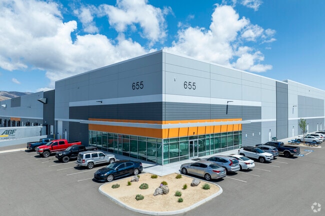
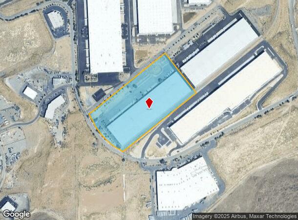
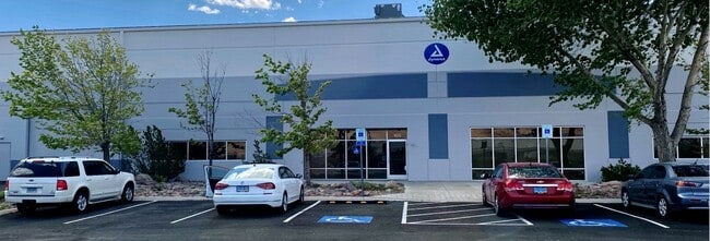
725 Waltham Way
Reno, NV
Dp Management Services, Inc
005-021-41
PARCEL MAP ID : 99-24C LOT : BLOCK : PT S32 T20N S5 T19N R22E TOWN : INDUSTRIAL GID
Lightindustrial
Storey
X
Nevada
32031C3091G
99
2024
17.44 AC
2025
Storey County
970200
Reno/Sparks
330,000 SF
DEMOGRAPHICS near 725 Waltham Way
1 Mile
3 Mile
5 Mile
2024 Total Population
2
17
38
2029 Population
2
19
40
Pop Growth 2024-2029
0.00%
+ 11.76%
+ 5.26%
Average Age
0
43
45
2024 Total Households
1
7
14
HH Growth 2024-2029
0.00%
0.00%
+ 7.14%
Median Household Inc
$0
$67,500
$59,999
Avg Household Size
.00
2.10
2.20
2024 Avg HH Vehicles
1.00
2.00
2.00
Median Home Value
$250,000
$299,999
$450,000
Median Year Built
0
1997
1995
Nearby Places
Map Layers
Map Styles
 Street
 Aerial
- Restaurants
- Banks
- Shops
- Fitness
- Groceries
PUBLIC TRANSPORTATION
AIRPORT
Reno/Tahoe International
DRIVE
WALK
Distance
Reno/Tahoe International
44 min
21.2 mi
Freight Ports
Port of Stockton
DRIVE
WALK
Distance
Port of Stockton
228 min
195.5 mi
Nearby Properties
Address
Land Use
TOTAL SIZE
Lot Size
Zoning
Address
Land Use
TOTAL SIZE
Lot Size
Zoning
1,219,360 SF
345.23 AC
GR 40% / I
Address
Land Use
TOTAL SIZE
Lot Size
Zoning
1,090,282 SF
46.32 AC
I2
Address
Land Use
TOTAL SIZE
Lot Size
Zoning
547,249 SF
50 AC
I2
Address
Land Use
TOTAL SIZE
Lot Size
Zoning
434,480 SF
I2
Address
Land Use
TOTAL SIZE
Lot Size
Zoning
410,750 SF
35.52 AC
I-2;INDUST
Address
Land Use
TOTAL SIZE
Lot Size
Zoning
437,830 SF
25.36 AC
I2
Address
Land Use
TOTAL SIZE
Lot Size
Zoning
447.32 AC
I 33% / GR
Address
Land Use
TOTAL SIZE
Lot Size
Zoning
432,320 SF
25.93 AC
I-2;INDUST
Address
Land Use
TOTAL SIZE
Lot Size
Zoning
525,873 SF
28.03 AC
I2
Address
Land Use
TOTAL SIZE
Lot Size
Zoning
332,640 SF
18.36 AC
I-2;INDUST
Address
Land Use
TOTAL SIZE
Lot Size
Zoning
174,112 SF
109.84 AC
I-2;INDUST
Address
Land Use
TOTAL SIZE
Lot Size
Zoning
326,807 SF
19.13 AC
Address
Land Use
TOTAL SIZE
Lot Size
Zoning
420,000 SF
23.83 AC
I-2;INDUST
Address
Land Use
TOTAL SIZE
Lot Size
Zoning
225.50 AC
Address
Land Use
TOTAL SIZE
Lot Size
Zoning
300,000 SF
15.78 AC
I-2;INDUST
Address
Land Use
TOTAL SIZE
Lot Size
Zoning
143.93 AC
GR 2% / I
Address
Land Use
TOTAL SIZE
Lot Size
Zoning
10.89 AC
Address
Land Use
TOTAL SIZE
Lot Size
Zoning
42,602 SF
10 AC
I-2;INDUST
Address
Land Use
TOTAL SIZE
Lot Size
Zoning
168,480 SF
13.48 AC
I-2;INDUST
Address
Land Use
TOTAL SIZE
Lot Size
Zoning
88,620 SF
10.31 AC
I2
Address
Land Use
TOTAL SIZE
Lot Size
Zoning
491.09 AC
Address
Land Use
TOTAL SIZE
Lot Size
Zoning
33,034 SF
15 AC
I2
Address
Land Use
TOTAL SIZE
Lot Size
Zoning
31.64 AC
I2
Address
Land Use
TOTAL SIZE
Lot Size
Zoning
120 AC
I 43% / GR
Address
Land Use
TOTAL SIZE
Lot Size
Zoning
147.28 AC
GC
Address
Land Use
TOTAL SIZE
Lot Size
Zoning
5,278 SF
5.79 AC
I-2;INDUST
Address
Land Use
TOTAL SIZE
Lot Size
Zoning
20.07 AC
Address
Land Use
TOTAL SIZE
Lot Size
Zoning
403.30 AC
I 12% / GR
Address
Land Use
TOTAL SIZE
Lot Size
Zoning
470.11 AC
GC 1% / I
The World's #1 Commercial Real Estate Marketplace
Connect with us
© 2025 CoStar Group
The information above has been obtained from sources believed reliable. While we do not doubt its accuracy we have not verified it and make no guarantee, warranty or representation about it. It is your responsibility to independently confirm its accuracy and completeness. Any projections, opinions, assumptions, or estimates used are for example only and do not represent the current or future performance of the property. The value of this transaction to you depends on tax and other factors which should be evaluated by your tax, financial, and legal advisors. You and your advisors should conduct a careful, independent investigation of the property to determine to your satisfaction the suitability of the property for your needs.